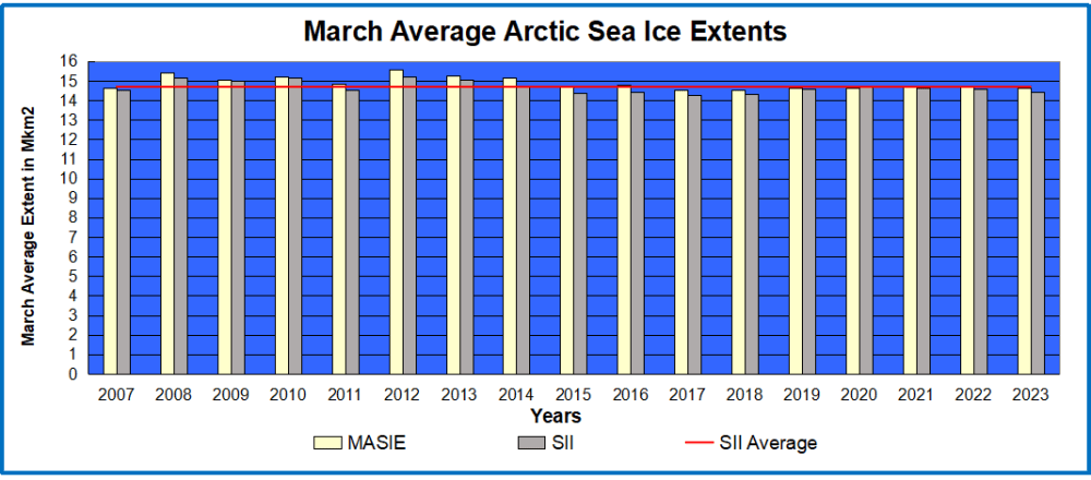
Previous posts showed 2023 Arctic Ice did break the 15M km2 ceiling early March peaking just two days after the 17 year average. So there is plenty of Arctic drift ice for sailers to be aware. The graph above shows that the March monthly average has varied little since 2007, typically around the SII average of 14.7 M km2. Of course there are regional differences as described later on.
Dr. Judah Cohen at AER summarizes the situation:
If you can believe it, the major disruption of the polar vortex (PV) and is referred to as a major sudden stratospheric warming (SSW) from mid-February is still influencing the weather even into April. Relatively cold temperatures have become more widespread across Northern Europe and should continue. Northern Asia has been surprisingly quite mild but colder temperatures are predicted across Siberia for April (see Figures 6 and 9). Across North America it seems to be more what you see is what you get, no end in sight of the pattern that began in November – cold west and mild east.

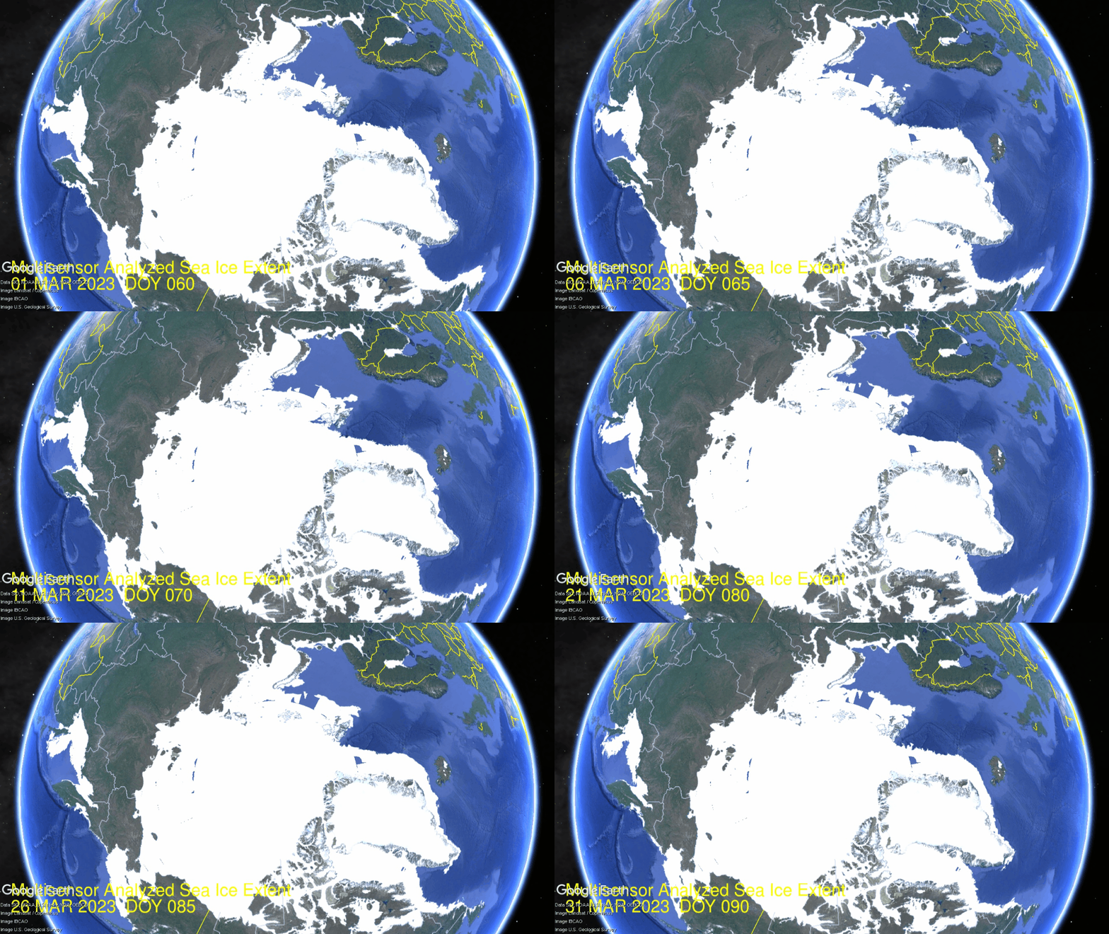
The High pressure areas were forecast to warm over the Pacific Arctic basins, and extending over to the European side, while the cold Low area is presently extending down into North America, bringing some snow and freezing rain on April 1 in Montreal (no joke). There’s also ice for Montrealers to beware. The effect on Arctic Ice extents is shown in the animation below:
Over the last 31 days, there were gains and then losses, mostly in the Pacific basins. Okhotsk upper left lost 360k km2 (now at 90% of max) while Bering lower left lost 135k m2 to be 60% of max. Baffin Bay lower right lost 420k km2 over the same period. Meanwhile, Greenland Sea center right gained 70k km2 to reach 105% of its max. The effect on NH total ice extents is presented in the graph below.
The graph above shows ice extent through March comparing 2023 MASIE reports with the 17-year average, other recent years and with SII. After surpassing average on day 64, 2023 ice extents dropped sharply and at March end matched both 2018 and 2021. SII showed lower extents throughout, but ended with a small deficit to MASIE.

The table below shows the distribution of sea ice across the Arctic regions.
| Region | 2023090 | Day 90 Average | 2023-Ave. | 2018090 | 2023-2018 |
| (0) Northern_Hemisphere | 14393146 | 14613608 | -220462 | 14456459 | -63313 |
| (1) Beaufort_Sea | 1070966 | 1070154 | 812 | 1069836 | 1131 |
| (2) Chukchi_Sea | 966006 | 964029 | 1977 | 964121 | 1885 |
| (3) East_Siberian_Sea | 1087137 | 1086163 | 974 | 1087137 | 0 |
| (4) Laptev_Sea | 897845 | 897010 | 835 | 897845 | 0 |
| (5) Kara_Sea | 933984 | 919079 | 14905 | 934790 | -806 |
| (6) Barents_Sea | 718169 | 651091 | 67078 | 790204 | -72034 |
| (7) Greenland_Sea | 816301 | 650261 | 166039 | 533694 | 282607 |
| (8) Baffin_Bay_Gulf_of_St._Lawrence | 1202833 | 1402909 | -200077 | 1380945 | -178112 |
| (9) Canadian_Archipelago | 854843 | 853082 | 1760 | 853109 | 1734 |
| (10) Hudson_Bay | 1260903 | 1254610 | 6293 | 1259857 | 1047 |
| (11) Central_Arctic | 3248013 | 3233036 | 14977 | 3202650 | 45363 |
| (12) Bering_Sea | 505101 | 724369 | -219269 | 277469 | 227632 |
| (13) Baltic_Sea | 60959 | 62776 | -1818 | 99317 | -38359 |
| (14) Sea_of_Okhotsk | 763690 | 834337 | -70647 | 1097524 | -333834 |
Overall NH extent March 31 was below average by 220k km2, or 1.5%. The two major deficits are Bering Sea and Baffin Bay, partly offset by a surplus in Greenland Sea. The onset of spring melt is as usual in most regions.


Reblogged this on Climate Collections.
LikeLike