This post is the fourth of five to alert readers to a compilation of the scientific and economic case against the claims of IPCC supporters and anti-fossil fuel activists. David Stockman provides the evidence and the arguments against the IPCC policy framework in a series of five essays published at International Man under the title The GreenMageddon and What It Means for You. I will state the five themes he develops in his essays, along with some excerpts and images to illustrate the main points. Here is the fourth theme overview and discussion.
4. Zero Carbon is suicidal because it requires cutting off essential energy supplies with nothing to replace them. Renewables can not keep pace with increasing electrical demand, let alone replace any baseload thermal power plants with wind or solar generation. Nor will hydro or nuclear power cover the losses from shuttering thermal power plants.
Overview
The chart below dramatically underscores why the CO2 witch-hunt is such a deadly threat to future prosperity and human welfare. To wit, even after decades of green energy promotion and huge subsidies from the state, renewables accounted for only 5% of primary global energy consumption in 2019 because:
They are still very un-competitve (high cost) relative to the installed base of fossil, nuclear and hydroelectric energy; and,
They do not really even account for the 5% share reflected in the chart in terms of ability to delivery work to the economy owing to intermittency of wind and solar power and the fact that by convention government scorekeepers gross-up renewables-based electrical power delivered to end-users to account for transmission and distribution (T&D) losses in the electric power grid.
By contrast, the 84% share attributed to oil, natural gas and coal is actually far larger in practical terms as we look into the future. That’s because most of the prime hydro sources have been tapped out long ago and are therefore not a meaningful source of growth. During the last 10 years, for example, US hydro-power output has only increased from 275 billion KWh to 288 billion KWh or by barely 0.24% per annum.
Likewise, nuclear power capacity outside of China stopped growing decades ago due to massive political and regulatory resistance. Germany, for example, is in the process of closing its last nuclear plants from a fleet that once generated 170,000 GW hours annually (2000) and is now generating only 75,000 GW hours, with a zero target by the year 2030. Even in the US, nuclear power remains dead in the water, with annual output rising from 754 billion KWh in 2000 to just 809 billion KWh in 2019.
Beyond that, the Climate Howlers are not talking about a gradual substitution of solar and wind for the three fossil based sources of primary energy as existing plants reach the end of their useful lives over the next 50 years.
To the contrary, zero net CO2 emissions targets for 2050 will require the massive early retirement and dismantlement of perfectly good power plants and tens of millions of internal combustion (IC) engine vehicles.
Closing Functional Power Plants is a Double Loss
The prospect of substituting green power for existing fossil fuel capacity over the next several decades is where the rubber meets the road. But to grasp the full extent of the impending calamity it is necessary to recall that Keynesian GDP accounting inherently obfuscates the true economic cost in a drastically downward direction.
In fact, Keynesian GDP accounting is just the modern iteration of Frederic Bastiat’s famous “broken window fallacy”. Gross capital spending gets added to the total of GDP with no offset for depreciation and asset write-offs. That’s why, we suppose, climate change activists get all giddy about the alleged economic growth benefits and job gains from green investment: They just don’t count all the assets wasted and jobs lost by shutting down efficient coal mines or fossil-fired utility plants.
Nor are we talking about small amounts. To come even close to the utterly ridiculous COP26 target of net zero emissions by 2050 literally tens of trillions worth of fossil-fired power plants, heating units, chemical processing plants and internal combustion engine vehicles would have to be decommissioned and taken out of service long before their ordinary useful economic lives had been reached.
Fossil fuel consumption in the electric power utility sector—the only sector where green energy has even made a dent—-has hardly declined at all.
What happened, instead, is that between 2000 and 2019, US coal and oil-fired generation dropped from 2,090 billion KWhs to 1,004 billion KWhs or by 52%, but that was nearly off-set by a huge jump in natural gas-fired generation. Specifically, natural gas fired output of 601 billion KWhs in 2000 rose to 1,586 billion KWhs by 2019, a gain of 164%. Accordingly, the needle on overall fossil-based generation hardly moved, dropping from 2,691 billion KWhs in 2000 to 2,590 billion KWhs in 2019.
So the question recurs, how in the world do these lame-brains expect to get to zero CO2 emissions from the utility sector when over the last 19-years, the rate of fossil-fired production has declined by a trivial –0.20% per annum.Moreover, as we suggested above regarding the global balances, there is no reason whatsoever to expect any material displacement of fossil-based power production by nuclear or hydro. Combined these two sectors produced 1,097 billion KWhs in 2019, but if anything production is likely to fall in the next several decades.
That’s right. In the last quarter quarter century there has been a grand total of two nuke plants commissioned. This means quite evidently that the nation’s grand total of 94 operating commercial nuclear reactors at 56 nuclear power plants in 28 states are old as the hills— averaging 25-40 years old and heading for decommissioning in the normal course.
The implication cannot be gainsaid. Unless there is a total political reversal with respect to nuclear power, the 809 billion KWHs generated in 2019, which represented nearly 20% of total utility output, will likely be shrinking from normal retirements faster than new plants can be licensed, built and made operational, a process which typically takes well more than a decade.
How Will Growing Demand for Power Be Met?
Finally, there is the matter of growth. Even at the tepid level of GDP growth during the last decade, and despite continued improvements in the efficiency of electrical power use in the US economy, total power output rose from 3,951 billion KWHs in 2009 to 4,127 billion KWhs in 2019, representing a modest 0.44% per annum growth rate.
Then again, a continuation of that modest growth trend—which would be the minimal gain compatible with a continued slow rise in real GDP—would result in total power output requirements of 4,427 billion KWhs by 2035 or 300 billion KWHs more than current levels.
So here’s the skunk in the woodpile. Total solar and wind-fueled power output in 2019 was just 367 billion KWhs or 8.9% of total utility output. That is, it will require the equivalent of fully 82% of current so-called green power production just to supply projected system growth. And that’s to say nothing of replacing nuclear production that is likely to be falling due to retirements and obsolescence or, more importantly, displacing some of the 2,590 billion KWhs of fossil production still in the nation’s electrical power grid.
Let us re-iterate: Unless a large share of that 2,590 billion KWhs of capacity is shuttered, the idea of zero net CO2 emissions is a pipe dream.
At the same time, it would take trillions of taxpayer subsidies to lift the current 367 billion KWhs of green power production toward even half of power requirements by 2035, which would exceed 2,200 KWhs. And that simply isn’t going to happen in a month of Sundays.
Worse, Power Output and Reliability Requires Over-Sized Renewables Installations
Moreover, that’s not even the half of it. Green power production, and especially wind which accounted for 4X more output than solar in 2019, ( 295 billion KWhs versus 72 billion KWhs) is highly intermittent based on seasonal patterns and daily wind strength. Nationally, wind plant performance tends to be highest during the spring and lowest during the mid-to late summer, while performance during the winter (November through February) is around the annual median. However, this pattern can vary considerably across regions, mostly based on local atmospheric and geographic conditions.
In a word, to get the same output and reliability as gas or coal-fired base-load plants, green power plants need to be drastically oversized both in terms of maximum output capacity and back-up storage units. As shown below, for most regions of the country, median monthly wind capacity factors range between just 25% and 35%.
Needless to say, low capacity factors mean high all-in costs for electrical energy delivered to the grid. Analysts use a concept to capture this called LCOE (levelized cost of energy), which is the present value of total cost over the lifetime of a plant divided by the cumulative amount of electricity generated over the lifetime.
Accordingly, the cost of funding power output growth plus displacement of substantial amounts of fossil fired production would be staggering. Recent detailed study by the Institute for Energy Research show the LCOE calculations for the range of fuels sources:
LCOE Per Megawatt Hour Of Capacity:
Combined cycle natural gas: $36;
Nuclear: $33;
Hydro: $38;
Coal: $41;
Onshore wind: $85;
Solar PV: $89;
Offshore Wind: $132.
These differentials between conventional and green sources of power generation are clearly staggering and contradict the constant propaganda from the Climate Howlers, who falsely claim that solar and wind are cheaper than existing power sources.
But as we will amplify in the final installment (Part 5), the actual scenario is far more forbidding than even these all-in cost differentials would suggest. That’s because the second part of the green agenda is to convert the nation’s efficient fleet of 285 million IC engine vehicles to electric battery power and 70 million natural gas and oil heated homes to green electricity, among others.
What that will do, of course, is make peak power demand swings on the grid far more extreme—even violent—just as the reliability of a green-powered utility sector falls sharply.
This post is the third of five to alert readers to a compilation of the scientific case against the claims of IPCC supporters and anti-fossil fuel activists. David Stockman provides the evidence and the arguments against the IPCC policy framework in a series of five essays published at International Man under the title The GreenMageddon and What It Means for You. I will state the five themes he develops in his essays, along with some excerpts and images to illustrate the main points. Here is an overview followed by the third theme.
Overview
The geological and paleontological evidence overwhelmingly says that today’s average global temperature of about 15 degrees C and CO2 concentrations of 420 ppm are nothing to fret about. Even if they rise to about 17–18 degrees C and 500–600 ppm by the end of the century, it may well balance or improve the lot of mankind.
After all, bursts of civilization during the last 10,000 years uniformly occurred during the red portions of the graph below. The aforementioned river civilizations—the Minoan, the Greco-Roman era, the Medieval flowering, and the industrial and technological revolutions of the present era. At the same time, the several lapses into the dark ages happened when the climate turned colder (blue).
And that’s only logical. When it’s warmer and wetter, growing seasons are longer, and crop yields are better—regardless of the agricultural technology and practices of the moment. And it’s better for human and community health, too—most of the deadly plagues of history have occurred in colder climates, such as the Black Death of 1344–1350..
Yet, the Climate Crisis Narrative employs two deceptive devices which are contradicted by earth’s climate history:
a. Planetary temperatures have been far higher than today, both long ago (over 600 million years) and recently (last 10,000 years) with no doomsday loop occurring.
b.It is claimed global warming is a one-way street from rising GHGs, when in fact higher CO2 concentrations are a consequence and by-product, not a driver and cause, of the current naturally rising temperatures.
W. J. Davis (2017)
Again, the now “canceled” history of the planet knocks the CO2-driver proposition into a cocked hat. During the Cretaceous Period between 145 and 66 million years ago, a natural experiment provided complete absolution for the vilified CO2 molecule. During that period, global temperatures rose dramatically from 17 degrees C to 25 degrees C—a level far above anything today’s Climate Howlers have ever projected.
Alas, CO2 wasn’t the culprit. According to science, ambient CO2 concentrations actually tumbled during that 80-million-year expanse, dropping from 2,000 ppm to 900 ppm on the eve of the Extinction Event 66 million years ago.
3. Climatists weaponize natural events to gain social control for a global agenda. It’s About Power, Not Truth or Humanity.
You would think that this powerful countervailing fact would give the CO2 witch-hunters pause, but that would be to ignore what the whole climate change brouhaha is actually about. That is, it’s not about science, human health and well-being or the survival of planet Earth; it’s about politics and the ceaseless search of the political class and the apparatchiks and racketeers who inhabit the beltway for still another excuse to aggrandize state power.
Indeed, the climate change narrative is the kind of ritualized policy mantra that is concocted over and over again by the political class and the permanent nomenklatura of the modern state—professors, think-tankers, lobbyists, career apparatchiks, officialdom—in order to gather and exercise state power.
The Obvious Exploitation of Natural Events
Indeed, fabrication of false problems and threats that purportedly can only be solved by heavy-handed state intervention has become the modus operandi of a political class that has usurped near-complete control of modern democracy.
In doing so, however, the ruling elites have gotten so used to such unimpeded success that they have become sloppy, superficial, careless and dishonest. For instance, the minute we get a summer heatwave, these natural weather events are jammed into the global warming mantra with nary a second thought by the lip-syncing journalists of the MSM.
Heatwaves
Yet there is absolutely no scientific basis for all this tom-tom beating. In fact, NOAA publishes a heatwave index based on extended temperature spikes, which last more than 4 days and which would be expected to occur once every 10 years based on the historical data.
As is evident from the chart below, the only true heatwave spikes we have had in the last 125 years were during the dust bowl heat waves of the 1930s. The frequency of mini-heatwave spikes since 1960 is actually no greater than it was from 1895 to 1935.
Hurricanes
Likewise, all it takes is a good Cat 2 hurricane and they are off to the races, gumming loudly about AGW. Of course, this ignores entirely NOAA’s own data as summarized in what is known as the ACE (accumulated cyclone energy) index.
This index was first developed by renowned hurricane expert and Colorado State University professor William Gray. It uses a calculation of a tropical cyclone’s maximum sustained winds every six hours. The latter is then multiplied by itself to get the index value and accumulated for all storms for all regions to get an index value for the year as shown below for the past 170 years (the blue line is the seven-year rolling average).
That is to say, hundreds of billions of dollars of insurance coverage were then and still is being written with ACE as a crucial input. Yet, if you examine the 7-year rolling average (blue line) in the chart, it is evident that ACE was as high or higher in the 1950s and 1960s as it is today and that the same was true of the late 1930s and the 1880–1900 periods. [See also Bill Gray: H20 is Climate Control Knob, not CO2]
If global warming were generating more hurricanes as the MSM constantly maintains, the increase would be uniform across all of these subregions, but it’s clearly not. Since the year 2000, for example,
the Eastern Caribbean has had a modest increase in both tropical storms and higher-rated Cats relative to most of the past 170 years;
the Western Caribbean has not been unusual at all, and, in fact, has been well below the counts during the 1880–1920 period; and
the Bahamas/Turks & Caicos region, since 2000, has actually been well weaker than during 1930–1960 and 1880–1900
The actual truth of the matter is that Atlantic hurricane activity is generated by atmospheric and ocean temperature conditions in the eastern Atlantic and North Africa. Those forces, in turn, are heavily influenced by the presence of an El Niño or La Niña in the Pacific Ocean. El Niño events increase the wind shear over the Atlantic, producing a less-favorable environment for hurricane formation and decreasing tropical storm activity in the Atlantic basin. Conversely, La Niña causes an increase in hurricane activity due to a decrease in wind shear.
These Pacific Ocean events, of course, have never been correlated with the low level of natural global warming now underway.
The number and strength of Atlantic hurricanes may also undergo a 50- to 70-year cycle known as the Atlantic multidecadal oscillation. Again, these cycles are unrelated to global warming trends since 1850.
Wildfires
As it happens, the same story is true with respect to wildfires—the third category of natural disasters that the Climate Howlers have glommed onto. But in this case, it’s bad forestry management, not man-made global warming, which has turned much of California into a dry wood fuel dump.
But don’t take our word for it. This comes from the George Soros-funded Pro Publica, which is not exactly a right-wing tin foil hat outfit. It points out that environmentalists had shackled federal and state forest management agencies so much so that today’s tiny “controlled burns” are but an infinitesimal fraction of what Mother Nature herself accomplished before the helping hand of today’s purportedly enlightened political authorities arrived on the scene.
“Academics believe that between 4.4 million and 11.8 million acres burned each year in prehistoric California. Between 1982 and 1998, California’s agency land managers burned, on average, about 30,000 acres a year. Between 1999 and 2017, that number dropped to an annual 13,000 acres. The state passed a few new laws in 2018 designed to facilitate more intentional burning. But few are optimistic this, alone, will lead to significant change.
We live with a deathly backlog. In February 2020, Nature Sustainability published this terrifying conclusion: California would need to burn 20 million acres—an area about the size of Maine—to restabilize in terms of fire.”
Among other proofs that industrialization and fossil fuels aren’t the culprit is the fact that researchers had shown that when California was occupied by indigenous communities, wildfires would burn up some 4.5 million acres a year. That’s nearly six times the 2010–2019 period, when wildfires burned an average of just 775,000 acres annually in California.
Beyond the untoward clash of all of these natural forces of climate and ecology with misguided government forest and shrubland husbandry policies, there is actually an even more dispositive smoking gun, as it were.
To wit, the Climate Howlers have not yet embraced the apparent absurdity that the planet’s purportedly rising temperatures have targeted the Blue State of California for special punishment. Yet when we look at the year-to-date data for forest fires, we find that unlike California and Oregon, the US as a whole is now experiencing the weakest fire years since 2010.
You just can’t go from 2.7 million burned acres in 2010 to 7.2 million acres in 2012, then back to 2.7 million acres in 2014, then to 6.7 million acres in 2017, followed by just 3.7 million acres in 2020—and still argue along with the Climate Howlers that the planet is angry.
National fire data year to date:
On the contrary, the only real trend evident is that on a decadal basis during recent times, average forest fire acreage in California has been slowly rising, owing to the above-described dismal failure of government forest management policies. But even the mildly rising average fire acreage trend since 1950 is a rounding error compared to the annual averages from prehistoric times, which were nearly 6 times greater than during the most recent decade.
Nor is this lack of correlation with global warming just a California and US phenomenon. As shown in the chart below, the global extent of drought, measured by five levels of severity, with brown being the most extreme, has shown no worsening trend at all during the past 40 years.
Global Extent of Five Levels Of Drought, 1982–2012
Public Discourse Contaminated by Imaginary Climate Crisis Notion
This brings us to the gravamen of the case. To wit, there is no climate crisis whatsoever, but the AGW hoax has so thoroughly contaminated the mainstream narrative and the policy apparatus in Washington and capitals all around the world that contemporary society is fixing to commit economic hari-kari.
That’s because, contrary to the phony case that the rise of fossil fuel use after 1850 has caused the planetary climate system to become unglued, there has been a massive acceleration of global economic growth and human well-being. One essential element behind that salutary development has been the massive increase in the use of cheap fossil fuels to power economic life.
The chart below could not be more dispositive. During the pre-industrial era between 1500 and 1870, real global GDP crawled along at just 0.41% per annum. By contrast, during the past 150 years of the fossil fuel age, global GDP growth accelerated to 2.82% per annum–or nearly 7 times faster.
This higher growth, of course, in part resulted from a larger and far healthier global population made possible by rising living standards. Yet, it wasn’t human muscle alone that caused the GDP level to go parabolic, as per the chart below.
It was also due to the fantastic mobilization of intellectual capital and technology. One of the most important vectors of the latter was the ingenuity of the fossil fuel industry in unlocking the massive trove of stored work that Mother Nature extracted, condensed, and salted away from the incoming solar energy over the long warmer and wetter eons of the past 600 million years.
Yes, that dramatic rise in prosperity in generating fossil fuel consumption has given rise to a commensurate increase in CO2 emissions. But contrary to the Climate Change Narrative, CO2 is not a pollutant!
As we have seen, the correlated increase in CO2 concentrations—from about 290 ppm to 415 ppm since 1850—amounts to a rounding error in both the long-trend of history and in terms of atmospheric loadings from natural sources.
As to the former, concentrations of less than 500 ppm are only recent developments of the last ice age, while during prior geologic ages concentrations reached as high as 2400 ppm.
Likewise, the oceans contain an estimated 37,400 billion tons of suspended carbon, land biomass has 2,000-3,000 billion tons and the atmosphere contains 720 billion tons of CO2. The latter alone is more than 20X current fossil emissions (35 billion tons) shown below.
Of course, the opposite side of the equation is that oceans, land and atmosphere absorb CO2 continuously so the incremental loadings from human sources is very small. That also means that even a small shift in the balance between oceans and air would cause a much more severe rise/fall in CO2 concentrations than anything attributable to human activity.
But since the Climate Howlers falsely imply that the “pre-industrial” level of 290 parts per million was extant since, well, the Big Bang and that the modest rise since 1850 is a one-way ticket to boiling the planet alive, they obsess over the “sources versus sinks” balance in the carbon cycle for no valid reason whatsoever.
This post is the second of five to alert readers to a compilation of the scientific case against the claims of IPCC supporters and anti-fossil fuel activists. David Stockman provides the evidence and the arguments against the IPCC policy framework in a series of five essays published at International Man under the title The GreenMageddon and What It Means for You.I will state the five themes he develops in his essays, along with some excerpts and images to illustrate the main points. Here is an overview followed by the second theme.
Overview
The assembled governments of the world meeting in Glasgow for COP26 are fixing to declare war on the backbone of modern economic life and the abundance and relief from human poverty and suffering with which it has gifted the world. We are referring, of course, to its agenda to essentially drive fossil fuels—which currently make up 80% of BTU consumption—from the global energy supply system over the next several decades.
All of this is being done in the name of preventing global temperatures from rising by 1.5 degrees Celsius above “pre-industrial” levels.
But when it comes to the crucial matter of exactly which pre-industrial baseline level, you can see the skunk sitting on the woodpile a mile away. That’s because, as we showed in Part 1, global temperatures have been higher than the present—often by upward of 10–15 degrees Celsius—for most of the past 600 million years!
2. During our Holocene epoch, for the past 11.6 thousand years, earth’s climate has changed often with multiple periods, both warmer and and cooler than the present. The modern warming period since 1850 was preceded by the Medieval, the Roman, and the Minoan warming periods–each was cooler than the previous, and all of them warmer than the present. The last 1.5C of warming has been a boon to human agriculture and civilization, and the next 1.5C is likely to also be beneficial.
Moreover, during the more recent era since the great extinction event 66 million years ago, the decline in temperatures has been almost continuous, touching lower than current levels only during the 100,000-year glaciation cycles of the last 2.6 million years of the Pleistocene ice ages. Not unsurprisingly, therefore, the Climate Howlers have chosen to ignore 599,830,000 of those years in favor of the last 170 years (since 1850) alone.
Still, the juxtaposition of the temperature record of the last 66 million years and the sawed-off charts of the climate alarmists tells you all you need to know: to wit, they have simply banished all the “inconvenient” science from the narrative.
Global Average Temperature Trend, 1850–2018 per the Global Warming Narrative
Needless to say, there is a reason why they start the graphs in 1850, and it is not just because it was the tail-end of the Little Ice Age (LIA), from which low point the temperature trend might well climb upwards for a time as climatic conditions normalized.
Actually, the intellectual deception is far more egregious. To wit, the Climate Howlers want you to believe the absolutely anti-scientific notion that the global climate was in general equipoiseuntil the coal barons and the John D. Rockefeller’s of the mid-19th century set off a dangerous chain of climate dysfunction as they brought the stored solar energy embedded in coal and petroleum to the surface and released its combustion by-products–especially CO2—into the ambient air.
The Risible Myth Of Climate Equipoise
The global warming narrative is the most risible manifestation yet of this leap into self-righteous disregard for evidence, logic, and plausibility. For when you step back from the shrill, sanctimonious narrative that passes for the global warming catechism, the ridiculousness of its central claim that industrial society is destroying the climatic equipoise of the planet is self-evident.
For crying out loud, there has never been equipoise!
What there’s been is 4.5 billion years of wildly oscillating and often violent geologic evolution and climate disequilibrium owing to manifold natural causes, including:
plate tectonics that has sometimes violently impacted climate systems, especially the assembly and breakup of Pangaea between 335 million and 175 million years ago, and the continuous drift of the present-day continents thereafter;
asteroid bombardments;
the 100,000-year cycles of the Earth’s orbital eccentricity (it gets colder when it’s at maximum elongation);
the 41,000-year cycles of the Earth’s tilt on its axis, which oscillates between 22.1 and 24.5 degrees and thereby impacts the level of solar intake;
the wobble or precession of the earth’s rotation which impacts climate over the course of its 26,000 year cycles;
the recent 150,000 year glaciation and inter-glacial warming cycles;
the 1500 year sunspot cycles, where earth temperatures fall during solar minimums like the Maunder Minimum of 1645-1715 at the extreme of the LIA when sunspot activity virtually ceased.
The natural climate change now underway is, therefore, the product of powerful planetary forces that long predated the industrial age and which massively exceed the impact of industrial era emissions. As we indicated in Part 1, that the present conflation of these forces has resulted in a warming cycle is nothing new—warming has happened repeatedly even in modern times. Contrary to the false claims of the Climate Howlers,
Current mildly rising temperatures are in keeping with the historical truth that warmer is better for humanity and most other species, too.
Continued planetary equipoise requires no interventions whatsoever by the state to retard the use of prosperity-fostering fossil fuels or to subsidize and accelerate the adoption of high-cost renewable energy.
So the question recurs. What “pre-industrial” temperature baseline can be picked out of all these eras and all these climate change forces that would be anything but an arbitrary political, not science-based, choice?
After all, the science is agnostic. Mother Earth has weathered every kind of climate disequilibrium at both the colder and warmer ends of the spectrum and, crucially, experienced the eventual release of countervailing forces that took both temperature and CO2 levels back in the other direction.
We think the planet’s climatic resilience is especially evident in the fact that, after five major ice ages, warming forces returned with robust energy until they reversed again, thereby proving there is no doomsday loop that leads in linear fashion to inexorable catastrophe as is embedded in the climate models.
To enlarge, open image in new tab.
As we noted, during the Holocene Optimum, many of the Earth’s great ancient civilizations began and flourished because conditions were especially hospitable for agriculture and the generation of economic surpluses. The Nile River, for instance, had an estimated three times its present volume, indicating a much larger tropical region. In fact, 6,000 years ago, the Sahara was far more fertile than today and supported large herds of animals, as evidenced by the Tassili N’Ajjer frescoes of Algeria.
That is to say, warmer and wetter was far better for mankind than prior bouts of cold.
Indeed, prior to the post-1850 warming, there had been five distinct warming periods (red areas) since the last glaciers with temperatures above current levels. Never, of course, does this chart see the light of day in the mainstream climate change narrative.
Also, during this period, the Vikings established settlements in Iceland and Greenland. Long before the industrial era, Greenland was so warm, wet, and fertile that major colonization occurred after AD 980. At its peak, it included upward of 10,000 settlers, extensive farming, numerous Catholic churches, and a parliament that eventually voted for union with Norway.
Nor was the reversal from the hospitable climate of the Viking era settlements in Greenland merely a regional anomaly has some Climate Howlers have claimed. During the Medieval Warm period, great civilizations flourished in many other areas, which then became uninhabitable.
For instance, a great drought in the American southwest occurred between 1276 and 1299. Grand settlements like those in Chaco Canyon and Mesa Verde were abandoned. Tree-ring analysis has identified a period of no rain between 1276 and 1299 in these areas.
Needless to say, these extreme weather perturbations were not caused by industrial activity because there was none, and they occurred during a period when it was getting colder, not warmer!
From 1550 to AD 1850, global temperatures were at their coldest since the beginning of the Holocene 12,000 years ago. Hence the designation of this period as the Little Ice Age (LIA).
Self-evidently, when the LIA finally ended around 1850, global temperatures were at a modern nadir (no wonder the Climate Howlers start their charts in the middle of the 19th century).
Mann’s Attempt to Erase Pre-Industrial Warming
But the significance of this fact goes well beyond cropping the temperature charts at 1850. Actually, in order to erase the above-described oscillations of the modern climate, climate change advocates have actually gone so far as to literally attempt to airbrush them out of existence.
We are referring to what we call the climate “Piltdown Mann,” named for one Michael Mann, a newly minted Ph.D. (1998) who became the International Panel on Climate Change’s (IPCC) lead investigator and advocate for what famously became the “hockey stick” proof of global warming.
The latter, of course, was the blatant fraud embedded in the image that Al Gore made famous in his propagandistic movie “An Inconvenient Truth” in 2006. Suffice to say, the purpose of the hockey stick was to wipe out all the evidence summarized above.
That is, in lieu of the planet’s long-term and recent severe climate oscillations, the IPCC posited an entirely opposite thesis. Namely, for the pre-industrial millennium before 1900, global temperatures were nearly as flat as a board.
The only problem is that Mann’s graph was as phony as the Piltdown Man itself—the latter famously being confected in England in 1912 and conveniently “discovered” by an amateur anthropologist who claimed it was the missing link in human evolution. At length, it was shown that the fossil was a forgery; it consisted of a modern human cranium and an orangutan jaw with filed-down teeth.
In the case of the graph, Professor Mann and his accomplices at the IPCC doctored the evidence,used misleading data from southwestern US tree rings in lieu of abundant alternative data showing the contrary, and jiggered their computer models to generate pre-specified results.
That is, the models were produced by goal-seeking on the part of Mann and his associates to prove the man-made warming thesis. In essence, this was accomplished by simply pasting modern temperature records showing steady increases on top of a pre-industrial baseline that never happened.
The phony pre-industrial baseline is depicted by the yellow area in the graph for the period 1400–1900. The hockey stick-like eruption of the yellow space after 1900, of course, allegedly depicts the man-made temperature rise since the onset of the hydrocarbon age.
By contrast, the corrected version is in blue. In this version—which comports with the history of climate oscillations cited above—there is no hockey stick because the shaft never happened; it was invented by computer model manipulations, not extracted from the abundant scientific data on which the Mann study was allegedly based.
So the question is answered. The mid-19th century is exactly the wrong baseline from which to measure global temperature change during modern times.
The blue area of the chart, in fact, is the smoking gun that obliterates the whole predicate on which COP26 is being foisted upon the everyday people of the world.
The first graph appeared in the IPCC 1990 First Assessment Report (FAR) credited to H.H.Lamb, first director of CRU-UEA. The second graph was featured in 2001 IPCC Third Assessment Report (TAR) the famous hockey stick credited to M. Mann.
The most powerful and enigmatic forces on our weather are the Pacific El Nino and La Nina phenomena which cause floods and droughts on opposite sides of the Pacific. Unfortunately, climate modelers can’t predict them much more than three to five months ahead, which tells us there’s some big driver they are missing. But a new paper from Chinese researchers suggests that a large blob of water in the North Eastern Pacific is responding to something in solar cycles.
This vast slab has the catchy name of The North Pacific eastern subtropical mode water (NPESTMW). It sits about 100m below the surface and grows and shrinks as the solar cycles rise and fall. It appears to be a very important blob. A different paper last year found that changes in the NPESTMW volume led the El Nino events by about 9 months.(Liu, 2025)
Remarkably, they found in the 1991–2022 record, seven of eight
large drops in this water volume were followed by El Niño,
while eight of nine large increases were followed by La Niña.
If they are right, it would confirm what skeptics have been saying for years — that climate modelers need to pay a lot more attention to solar cycles in their big models and that one day we might even learn to predict El Ninos (by crikey) a whole year ahead. Finally, the experts might be able to tell us if next summer really will be a barbecue summer, and the farmers might get a bit more warning on whether to plant seed early or sell off the cattle.
Awkwardly for 4,000 UN climate experts, the more solar factors we add to the climate models, the smaller the role is for CO2. (It’s even more awkward for nations that spent a trillion dollars on climate control before we understood the climate.)
The mechanism
The researchers suggest (see the top image) that it’s the solar UV which probably creates this effect on the oceans from the top down. High energy UV rays hit the oxygen molecules in the stratosphere and split them into ozone. Ozone then absorbs more UV and warms up that part of the atmosphere. This changes the jet streams and winds below. And winds close to the ocean can take energy or heat out of the water as it evaporates, but they also stir it up (or not). Peak solar activity seems to suppress the orderly settling of the NPESTMW blob. Once the blob forms and sinks to 100m to 300m down, surprisingly it is very stable and carries the temperature, salinity and other chemistry for a long time. This is what is called “the ocean memory” in the paper’s title.
To enlarge, open image in new tab.
After solar activity peaks, for the next year or two in every cycle, the formation of the NPESTMW block is suppressed. This may be due to cyclonic wind stress anomalies that drive upwelling. However, at the solar minima the winds change creating the opposite downwelling effect and the water flows into the blob.
Complicating everything, the Atlantic Multidecadal Oscillation (AMO) acts like a gate. During warm phases of the AMO, it amplifies the solar cycle effect on the NE Pacific, which is why after looking at eight decades of data, the effect has been strongest since 1990.
The Sun’s energy output follows an approximately 11-year cycle of stronger and weaker activity. Although this variation is small, it can nonetheless produce detectable effects on Earth’s climate. Here, we show that the solar-cycle consistently modulates the volume of a subsurface water mass in the North Pacific Ocean: the North Pacific Eastern Subtropical Mode Water, which forms at the ocean surface in winter and sinks, transferring heat and carbon to the deep ocean and influencing climate variability on timescales of years to decades. We find that during periods of high solar activity, anomalous cyclonic circulation over the formation region weakens surface winds and reduces ocean heat loss, suppressing winter mixed layer deepening and mode water formation, while the associated upwelling inhibits the sinking of this water mass; the opposite occurs during low solar activity. However, the strength of this solar influence is not constant over time: it is further amplified by a long-term natural climate fluctuation in the Atlantic Ocean, helping explain why the Sun’s imprint on climate has been particularly pronounced since the 1990s. These findings reveal a new mechanism through which the Sun may influence climate predictability via the ocean’s subsurface memory.
Figure 5
Schematic diagram illustrating the pathway from enhanced solar irradiance to reduced NPESTMW formation during solar-active periods. Enhanced solar forcing induces negative SLP anomalies over the North Pacific through “top-down” stratospheric-tropospheric coupling, producing anomalous cyclonic circulation and reduced air-sea heat loss. These atmospheric changes suppress winter mixed layer depth, preventing the water mass from penetrating enough to ventilate the thermocline and form mode water. Additionally, cyclonic wind-induced upwelling anomaly opposes downward subduction (shading schematic), further hindering NPESTMW formation and ventilation. Critically, this solar-driven pathway is strongly modulated by the AMO phase: during positive AMO phases, stronger atmosphere-ocean coupling and enhanced mixed layer sensitivity to atmospheric forcing amplify the solar-NPESTMW relationship, whereas during negative AMO phases, weaker coupling and sensitivity damp this signal, rendering the solar imprint less detectable.
Solar Cycle Progression September 15, 2026
Footnote: Oceans Oviously Drive Global Warming
Going back to previous warmings prior to the satellite record shows that the entire rise of 0.8C since 1947 is due to oceanic, not human activity.
The exhibit shows since 1947 GMT warmed by 0.8 C, from 13.9 to 14.7, as estimated by Hadcrut4. This resulted from three natural warming events involving ocean cycles. The recent rise 2013-16 lifted temperatures by 0.2C. Previously the 1997-98 El Nino produced a plateau increase of 0.4C. Before that, a rise from 1977-81 added 0.2C to start the warming since 1947.
Importantly, the theory of human-caused global warming asserts that increasing CO2 in the atmosphere changes the baseline and causes systemic warming in our climate. On the contrary, all of the warming since 1947 was episodic, coming from three brief events associated with oceanic cycles. And in 2024 we saw an amazing episode with a temperature spike driven by ocean air warming in all regions, along with rising NH land temperatures, then dropping well below its peak.
The best context for understanding decadal temperature changes comes from the world’s sea surface temperatures (SST), for several reasons:
The ocean covers 71% of the globe and drives average temperatures;
SSTs have a constant water content, (unlike air temperatures), so give a better reading of heat content variations;
A major El Nino was the dominant climate feature in recent years.
Previously I used HadSST3 for these reports, but Hadley Centre has made HadSST4 the priority, and v.3 will no longer be updated. Reports since February are based on HadSST 4, but with a twist. The data is slightly different in the new version, 4.2.0.0 replacing 4.1.1.0. Product page is here.
The Current Context
The chart below shows SST monthly anomalies as reported in HadSST 4.2 starting in 2015 through August 2026. A global cooling pattern is seen clearly in the Tropics since its peak in 2016, joined by NH and SH cycling downward since 2016, followed by rising temperatures in 2023 and 2024 and cooling in 2025, now with a steady mild rising in 2026 pausing in May, resuming in June and rising sharply into July and August.
Note that in 2015-2016 the Tropics and SH peaked in between two summer NH spikes. That pattern repeated in 2019-2020 with a lesser Tropics peak and SH bump, but with higher NH spikes. By end of 2020, cooler SSTs in all regions took the Global anomaly well below the mean for this period. A small warming was driven by NH summer peaks in 2021-22, but offset by cooling in SH and the tropics, By January 2023 the global anomaly was again below the mean.
Then comes a third iteration of the pattern starting in 2023 and continuing through July 2026. Each year presents a summer NH warming spike with the highest in 2023, now approached by 2026. The Tropics have a different rhythm, rising dramatically in 2023, peaking in 2024, then rapidly declining hitting bottom end of 2025. Now in 2026 ENSO is returning with a spike raising temperatures in all regions pulling the Global anomaly upward. The August NH peak matches the 2023 NH peak along with higher values for SH, Tropics and Global anomaly.
Comment:
The climatists have seized on this unusual warming as proof their Zero Carbon agenda is needed, without addressing how impossible it would be for CO2 warming the air to raise ocean temperatures. It is the ocean that warms the air, not the other way around. Recently Steven Koonin had this to say about the phonomenon confirmed in the graph above:
El Nino is a phenomenon in the climate system that happens once every four or five years. Heat builds up in the equatorial Pacific to the west of Indonesia and so on. Then when enough of it builds up it surges across the Pacific and changes the currents and the winds. As it surges toward South America it was discovered and named in the 19th century It iswell understood at this point that the phenomenon has nothing to do with CO2.
Now people talk about changes in that phenomena as a result of CO2 but it’s there in the climate system already and when it happens it influences weather all over the world. We feel it when it gets rainier in Southern California for example. So for the last 3 years we have been in the opposite of an El Nino, a La Nina, part of the reason people think the West Coast has been in drought.
It has now shifted in the last months to an El Nino condition that warms the globe and is thought to contribute to this Spike we have seen. But there are other contributions as well. One of the most surprising ones is that back in January of 2022 an enormous underwater volcano went off in Tonga and it put up a lot of water vapor into the upper atmosphere. It increased the upper atmosphere of water vapor by about 10 percent, and that’s a warming effect, and it may be that is contributing to why the spike is so high.
A longer view of SSTs
To enlarge, open image in new tab.
The graph above is noisy, but the density is needed to see the seasonal patterns in the oceanic fluctuations. Previous posts focused on the rise and fall of the last El Nino starting in 2015. This post adds a longer view, encompassing the significant 1998 El Nino and since. The color schemes are retained for Global, Tropics, NH and SH anomalies. Despite the longer time frame, I have kept the monthly data (rather than yearly averages) because of interesting shifts between January and July. 1995 is a reasonable (ENSO neutral) starting point prior to the first El Nino.
The sharp Tropical rise peaking in 1998 was dominant in the record, starting Jan. ’97 to pull up SSTs uniformly before returning to the same level Jan. ’99. There were strong cool periods before and after the 1998 El Nino event. Then SSTs in all regions returned to the mean in 2001-2.
SSTS fluctuate around the mean until 2007, when another, smaller ENSO event occurs. There is cooling 2007-8, a lower peak warming in 2009-10, following by cooling in 2011-12. Again SSTs are average 2013-14.
Now a different pattern appears. The Tropics cooled sharply to Jan 11, then rise steadily for 4 years to Jan 15, at which point the most recent major El Nino takes off. But this time in contrast to ’97-’99, the Northern Hemisphere produces peaks every summer pulling up the Global average. In fact, these NH peaks appear every July starting in 2003, growing stronger to produce 3 massive highs in 2014, 15 and 16. NH July 2017 was only slightly lower, and a fifth NH peak still lower in Sept. 2018.
The highest summer NH peaks came in 2019 and 2020, only this time the Tropics and SH were offsetting rather adding to the warming. (Note: these are high anomalies on top of the highest absolute temps in the NH.) Since 2014 SH has played a moderating role, offsetting the NH warming pulses. After September 2020 temps dropped off down until February 2021. In 2021-22 there were again summer NH spikes, but in 2022 moderated first by cooling Tropics and SH SSTs, then in October to January 2023 by deeper cooling in NH and Tropics.
Then in starting in 2023 the Tropics flipped from below to well above average, while NH produced a summer peak extending into September higher than any previous year. 2024 and 2025 replicated summer peaks in the previous itertation. Now in 2026 July is nearly as high as 2023.
What to make of all this? The patterns suggest that in addition to El Ninos in the Pacific driving the Tropic SSTs, something else is going on in the NH. The obvious culprit is the North Atlantic, since I have seen this sort of pulsing before. After reading some papers by David Dilley, I confirmed his observation of Atlantic pulses into the Arctic every 8 to 10 years.
Contemporary AMO Observations
Through January 2023 I depended on the Kaplan AMO Index (not smoothed, not detrended) for N. Atlantic observations. But it is no longer being updated, and NOAA says they don’t know its future. So I find that ERSSTv5 AMO dataset has current data. It differs from Kaplan, which reported average absolute temps measured in N. Atlantic. “ERSST5 AMO follows Trenberth and Shea (2006) proposal to use the NA region EQ-60°N, 0°-80°W and subtract the global rise of SST 60°S-60°N to obtain a measure of the internal variability, arguing that the effect of external forcing on the North Atlantic should be similar to the effect on the other oceans.” So the values represent SST anomaly differences between the N. Atlantic and the Global ocean.
The chart above confirms what Kaplan also showed. As August is the hottest month for the N. Atlantic, its variability, high and low, drives the annual results for this basin. Note also the peaks in 2010, lows after 2014, and a rise in 2021. Then in 2023 the peak reached 1.4C before declining to 0.8, and now back up to 1.2C August 2026. An annual chart below is informative:
Note the difference between blue/green years, beige/brown, and purple/red years. 2010, 2021, 2022 all peaked strongly in August or September. 1998 and 2007 were mildly warm. 2016 and 2018 were matching or cooler than the global average. 2023 started out slightly warm, then rose steadily to an extraordinary peak in July. August to October were only slightly lower, but by December cooled by ~0.4C.
Then in 2024 the AMO anomaly started higher than any previous year, then leveled off for two months declining slightly into April. Remarkably, May showed an upward leap putting this on a higher track than 2023, and rising slightly higher in June. In July, August and September 2024 the anomaly declined, and despite a small rise in October, ended close to where it began.
Note 2025 started much lower than the previous year and headed sharply downward, well below the previous two years, and since April through September aligning with 2010. In October there was an unusual upward spike, now reversed down to match 2022 and 2016. The orange 2026 line started downward and is visible on top of 2016 purple line, then slightly higher, and now spiking higher in July and August up to 1.2C.
The pattern suggests the ocean may be demonstrating a stairstep pattern like that we have also seen in HadCRUT4.
The purple line is the average anomaly 1980-1996 inclusive, value 0.18. The orange line the average 1980-2026, value 0.42 also for the period 1996-2013. The red line is 2013-2026, value 0.72. As noted above, these rising stages are driven by the combined warming in the Tropics and NH, including both Pacific and Atlantic basins.
The oceans are driving the warming this century. SSTs took a step up with the 1998 El Nino and have stayed there with help from the North Atlantic, and more recently the Pacific northern “Blob.” The ocean surfaces are releasing a lot of energy, warming the air, but eventually will have a cooling effect. The decline after 1937 was rapid by comparison, so one wonders: How long can the oceans keep this up? And is the sun adding forcing to this process?
USS Pearl Harbor deploys Global Drifter Buoys in Pacific Ocean
An unusual and unexplained warming spike rose from -0.07C 2023/01 to a peak of 0.94C 2024/04. Temps then steadily declined to a low of 0.35C in 2026/01. Now there is a rise up to 0.68C in 2026/08. Historical records show that around 1875 was the coldest time in the last 10,000 years. That was the end of the Little Ice Age (LIA), and since then temperatures have warmed at an average rate of about 0.5C per century. The recovery of the biosphere and ocean warming resulted in rising levels of CO2 in the atmosphere.
Syun-Ichi Akasofu, founder of the University of Alaska Fairbanks’ Geophysical Institute reported on this pattern in 2009.
At times, there are warming spikes, in the 1930s and 40s for example, and the rate of rising CO2 goes up. At other times, such as 1950s and 60s, temperatures cool, and rising CO2 slows down. More recently, in 2023 and 24, we saw temperatures spike up before falling back down in 2025 and now in 2026. [Note: A study of ocean biochemistry processes confirms that since the end of the LIA rising temperatures have been accompanied by rising CO2 at a rate of ~2 ppm per year. [ See: Slam Dunk: Δtemp Drives Δco2, Ocean Biochemistry at Work ]
Furthermore, going back to previous warmings prior to the satellite record shows that the entire rise of 0.8C since 1947 is due to oceanic, not human activity.
Importantly, the theory of human-caused global warming asserts that increasing CO2 in the atmosphere changes the baseline and causes systemic warming in our climate. On the contrary, all of the warming since 1947 was episodic, coming from three brief events associated with oceanic cycles. And in 2024 we saw an amazing episode with a temperature spike driven by ocean air warming in all regions, along with rising NH land temperatures, then dropping well below its peak.
Previously I have demonstrated that changes in atmospheric CO2 levels follow changes in Global Mean Temperatures (GMT) as shown by satellite measurements from University of Alabama at Huntsville (UAH). A link to that background post is provided later below.
This post updates the analysis with the most current observations, testing the premise that temperature changes are predictive of changes in atmospheric CO2 concentrations. The chart at the top shows the two monthly datasets: CO2 levels in blue reported at Mauna Loa, and Global temperature anomalies in purple reported by UAHv6.1, both through August 2026. Would such a sharp increase in temperature be reflected in rising CO2 levels, according to the successful mathematical forecasting model? Would CO2 levels decline as temperatures dropped following the peak?
The answer is yes: that temperature spike resulted
in a corresponding CO2 spike as expected. Lower CO2 levels followed the temperature decline, now rising again.
Above are UAH temperature anomalies compared to CO2 monthly changes year over year.
Changes in monthly CO2 synchronize with temperature fluctuations, which for UAH are anomalies referenced to the 1991-2020 period. CO2 differentials are calculated for the present month by subtracting the value for the same month in the previous year (for example August 2026 minus August 2025). Temp anomalies are calculated by comparing the present month with the baseline month. Note the 2023-24 CO2 upward spike and 2025 drop following the temperature drop. The CO2 differential bottomed 2026/04 and is now rising again.
The table below shows clearly the pattern of observed temperatures declining along with declining rates of rising observed CO2. The CO2 rate peaked at 4.41 ppm, then declined over the next 25 months to 1.48 ppm, nearly the baseline rate since the LIA. There are fluctuations in the CO2 monthly response since the differential is influenced by the previous year as well as current year. By 2026/4, the rate of 1.48 ppm was one-third of the peak rate of 4.41 ppm.
Month
Temperature Anomaly
CO2 Diff. from Previous Year
2024\1
0.79
3.32
2024\2
0.86
4.23
2024\3
0.87
4.41
2024\4
0.94
3.14
2024\5
0.78
2.87
2024\6
0.7
3.25
2024\7
0.74
3.72
2024\8
0.75
3.31
2024\9
0.8
3.53
2024\10
0.73
3.56
2024\11
0.64
3.39
2024\12
0.62
3.54
2025\1
0.46
3.85
2025\2
0.5
2.54
2025\3
0.58
2.77
2025\4
0.61
3.13
2025\5
0.5
3.61
2025\6
0.48
2.70
2025\7
0.36
2.32
2025\8
0.39
2.49
2025\9
0.53
2.34
2025\10
0.53
2.49
2025\11
0.43
2.61
2025\12
0.3
2.09
2026\1
0.35
1.97
2026\2
0.39
2.26
2026\3
0.38
2.01
2026\4
0.39
1.48
2026\5
0.53
1.83
2026\6
0.46
1.83
2026\7
0.48
1.25
2026\8
0.68
1.85
The final proof that CO2 follows temperature due to stimulation of natural CO2 reservoirs is demonstrated by the ability to calculate CO2 levels since 1979 with a simple mathematical formula:
For each subsequent year, the CO2 level for each month was generated
CO2 this month this year = a + b × Temp this month this year + CO2 this month last year
The values for a and b are constants applied to all monthly temps, and are chosen to scale the forecasted CO2 level for comparison with the observed value. Here is the result of those calculations.
In the chart calculated CO2 levels correlate with observed CO2 levels at 0.9989 out of 1.0000. This mathematical generation of CO2 atmospheric levels is only possible if they are driven by temperature-dependent natural sources, and not by human emissions which are small in comparison, rise steadily and monotonically. For a more detailed look at the recent fluxes, here are the results since 2015, an ENSO neutral year.
For this recent period, the calculated CO2 values match well the annual highs, while some annual generated values of CO2 are slightly higher or lower than observed at other months of the year. Still the correlation for this period is 0.9944.
Key Point
Changes in CO2 follow changes in global temperatures on all time scales, from last month’s observations to ice core datasets spanning millennia. Since CO2 is the lagging variable, it cannot logically be the cause of temperature, the leading variable. It is folly to imagine that by reducing human emissions of CO2, we can change global temperatures, which are obviously driven by other factors.
From 10.000 Years to 4: One Equation Falsifies the Entire IPCC CO₂ Narrative – by Jonathan Cohler
The video above is a recent presentation by Jonathan Cohler at EIKE ( European Climate and Energy Institute). The english audio is available. He does a complete and evidence-based destruction of IPCC “concensus” Climate Science. For those prefering to read I provide a transcript lightly edited from the captions, along with some bolds and key exhibits from the talk.
Just very briefly, I’m Jonathan Cohler. I’m a Harvard-trained physicist, AI researcher, software developer. I serve on the Heartland Institute’s Board of Policy Advisors, and I’m a member of the CO2 Coalition. And over the past year, I’ve authored six climate papers, both peer-reviewed and pre-print, with illustrious co-authors including Willie Soon, David Legates, Keston Green, and Ole Humlum.
Collectively, the papers falsify the entire IPCC framework.
I presented some of this at Heartland’s conference in Washington this April, but today at EIKE is the first public presentation of our newest paper on the bomb radiocarbon falsification of the IPCC CO2 attribution, and more. So I’m going to start here by sharing my screen with you so you can see the presentation. So for 38 years, numerous IPCC purported metrics and associated lies have been paraded before the world as settled science.
Today, I’m going to show you that none of them are true, and most aren’t even real. One note on language I use, I use the word lie in its plain sense, a statement that is not true. Intent is not part of the definition. Orwell’s 2 plus 2 equals 5 is a lie regardless of who says it or why. When I call an IPCC claim a lie, I’m stating it’s false.
That said, intent in this case is not in doubt. The IPCC has had 38 years of access to all the data and the resources of every major government on earth. It knows what it has been promulgating, it knows what it has been suppressing, and significant numbers of scientists know as well. I won’t name any individuals, they know who they are, but I will name the institution, the IPCC.
My presentation is based on five papers, my 2025 peer-reviewed paper, building on Essex et al., 2007, and proving again that global mean surface temperature, GMST, does not exist. Our 2026 peer-reviewed paper on the invalidity of Argo-based ocean heat content with co-authors Dave Legates, Keston Green, Ole Humlum, Franklin Soon, and Willie Soon. Our 2026 paper with co-author Willie Soon on the dominance of natural CO2 dynamics currently under review.
My pre-print proving my new physical tether theorem. And most recently, our paper with co-author Willie Soon analyzing 50 years of global bomb radiocarbon decay, falsifying the key assumptions of the IPCC carbon cycle framework. I want to acknowledge all my co-authors, and in particular, my mentor and dear friend Willie Soon, whose decades of courageous work made much of this possible. I also want to honor the truly seminal contributions of Christopher Essex and Demetris Koutsoyiannis, whose work laid the foundation for all my papers here.
So let’s start with the verdict. Every major public-facing claim of the Intergovernmental Panel on Climate Change, IPCC, is scientifically invalid and categorically false. Not uncertain, not weakened, not in need of more research, false. I’ll prove this in the next 35 minutes or so by math, physics, and data. Words lie. Math does not. A statement is either derivable from its premises or not. There is no, quote, 97% of mathematicians agree nonsense. There’s proof or there isn’t.
For 38 years, the IPCC has paraded a framework draped in equations, satellite data, supercomputer models, academy awards, even Nobel Prizes. A snake eating its own tail. Each piece appears to validate the next. Once you see that the circle is empty, the entire framework collapses. Each lie leads to the next. None stand on their own.
GMST,Global mean surface temperature, the number that has purportedly risen 1.1 degrees since 1850, the number whose further rise to 1.5 or 2 degrees is, “catastrophic”, what some have called, “the most important number in the world”. CMIP, the Coupled Model Intercomparison Project, those are the general circulation models tuned to reproduce GMST.
OHC stands for Ocean Heat Content,a physically meaningless global aggregate constructed by the same averaging machinery as GMST. EEI, Earth’s Energy Imbalance, the energy gain inferred from OHC overriding satellite radiation measurements. CO2, atmospheric carbon dioxide, the persistence and attribution modeled by Bern impulse response functions validated against CMIP purported driving force in the entire attribution chain.
And then the loop closes back on itself. GMST tunes the models. The models produce Bern. Bern produces the budgets. Budgets define the targets. Targets are written in GMST. Each of the five nodes is independently falsified by physics, data, and math.
Let’s begin. Node 1, GMST is physically meaningless.
It’s the anchor of every policy claim. The Paris Agreement is written in degrees of GMST. Equilibrium climate sensitivity is defined in GMST. Transient climate response is defined in GMST. Attribution regressions use GMST as a dependent variable. CMIP models are tuned to reproduce GMST trajectories.
But GMST was proven meaningless in a 2007 paper by Essex, McKitrick, and Andresen unrefuted in 19 years. Two months ago, my physical tether theorem paper established from axioms of classical science alone that GMST cannot exist in the real world. It’s completely physically meaningless.
You take valid local thermometer readings, average them, get a global average. Seems right. Why not? Think telephone numbers. Average the phone numbers of everyone in Boston and Halle. Then ask three simple questions. Whose phone number is it? Is it a phone number? Does it mean anything at all?
Temperature is an intensive property defined only under local
thermodynamic equilibrium in single connected systems, like a
phone number that applies to one point on a telecom network.
The Earth’s surface, oceans, and atmosphere are not in equilibrium. They’re an open-driven non-equilibrium system. Persistent gradients, persistent fluxes, in-homogeneity at every scale. Physics has no law for aggregating local temperatures into a global mean. Disconnected systems cannot affect each other. Unlike quantum mechanical spooky action at a distance, which Einstein doubted and my friend and colleague John Clauser proved real, there is no thermodynamics at a distance.
The temperature in Boston has zero effect on the temperature in Halle. Temperature is defined only in a connected equilibrium system, and it is precisely the partial derivative of U, internal energy, with respect to S, entropy. Every thermometer agrees.
For an aggregate of disconnected systems, there is no thermodynamics, period. The GMST formulas imposed by the IPCC, NASA, or NOAA are just made up. The output is a number, not a temperature. Not anything in the physical, real world. The 2007 Essex paper showed the consequences for averaging arithmetic, area weighted, mass weighted, fourth root, enthalpy weighted. They all yield different numbers and different trends from the same data.
The choice is arbitrary. This isn’t a quarrel over data adjustments. We’re not talking about urban heat islands, homogenization, data improvement. No amount of data improvements can fix a category error. No averaging convention can rescue it. My physical tether theorem states it formally.
An abstract math formula is scientifically valid if and only if it is connected to the physical world by a unique, physical law-governed objective link. For a connected, equilibrated system, that link exists. Temperature is precisely the partial derivative of U with respect to S, and every valid thermometer agrees. A unique mapping exists. For disconnected systems, no physics, no mapping, just arbitrary statistical aggregations with no unique operational definition. The outputs are meaningless numbers.
GMST is a number the IPCC has falsely labeled as a temperature. Consequences are immediate and total. The 1.5 degree C limit is not a physical threshold. It’s an arbitrary number with a fake label applied to a meaningless calculation. The claim that the planet is warm by 1.1 degrees C is not a measurement. The equilibrium climate sensitivity defined as a change in GMST per CO2 doubling is equally physically meaningless.
The AR5 attribution statement, “more than half of observed warming is anthropogenic”, is a regression on a dependent variable that doesn’t exist. Every claim built on GMST is null and void. And AR6 went further. They abandoned their own calibrated uncertainty language and declared human influence, “unequivocal”, and then proceeded to use the word at least 37 times.
Unequivocal is not a science word. Science does not produce unequivocal claims.
Math proofs do. Empirical science operates within probability and falsifiability. Karl Popper settled this long ago. By its own word choice, the IPCC has abandoned science. Node 1 falsified. Every quantity dependent on GMST collapses with it.
Node 2, CMIP models are tuned to a fiction.
Every IPCC projection comes from CMIP, the coupled model intercomparison project. The models are tuned so simulated GMST matches the numerically calculated and physically meaningless GMST. Remember, there is no observed GMST. Those are just Orwellian words that the IPCC uses. It is purely a calculation.
Models that fail to reproduce historical GMST are discarded or retuned. GMST is physically meaningless. The model tuning target is physically meaningless. The model extracted parameters are extracted against a physically meaningless target. This is not a small effect. Cloud feedbacks, radiative forcing, equilibrium climate sensitivity, transient climate response, every one is an emergent property of models optimized against a physically meaningless target.
Equilibrium climate sensitivity, look at what IPCC actually means by this. ECS is defined as the change in GMST between models at 280 and 560 ppm CO2 both run to model equilibrium. But the earth is never in equilibrium. The fact that a model converges to equilibrium proves it isn’t modeling the earth. The equilibrium is a feature of the model, not the earth.
And even that’s not true. The CMIP model purveyors don’t actually run to that fictional equilibrium. They run 150 years or so, observe the drift, and extrapolate. They assume the model will reach an equilibrium that it never reaches.
ECS is an assumed extrapolation of an unreached state of a model
that fails reality at the level of being able to converge in the first place.
All to promulgate a number physically meaningless by definition. If A is meaningless and B is meaningless, then A minus B is meaningless. A and B are both meaningless GMST values. I know this is twisted IPCC Orwellian stuff, but follow me here because this is what is actually happening. Trillions of dollars of policy are calibrated to a number that does not exist in the real world, to a fake equilibrium state that never occurs in a model that fails to represent earth by virtue of having that equilibrium state in the first place.
And the model itself contains essentially none of the physics that drives earth’s permanent non-equilibrium state, namely meaningful cloud microphysics and feedbacks, real solar variability, turbulence, phase changes, biological dissipation, and more. Node 2, falsified.
Node 3, IPCC’s Argo-derived ocean heat content is physically meaningless.
You’ll notice I keep repeating those words. It’s not just a tick. My personal favorite from the circle of lies. Argo has deployed roughly 4,400 autonomous floats across the oceans. Each measures local temperature, salinity, and pressure as they drift.
And ocean heat content is a real physical concept and a physical
phenomenon, but what the IPCC presents as ocean heat content is not.
Orwell strikes again. Argo-derived IPCC OHC is a global statistical aggregate fabricated from local measurements through five layers of processing that destroy all physical meaning. This is the official Argo map, and it looks impressive, but it’s cropped to hide the poles and doesn’t differentiate deep from upper floats.
This is the real picture from NOAA showing every float that surfaced in the 12 days prior to March 25. Look at the poles. Virtually no floats beyond 60 degrees. And the entire deep Argo fleet has deployed only 230 floats to the bottom half of the ocean, below 2,000 meters, where literally half of the thermal energy resides. But the Argo program calls that, “nearly complete global coverage” in perfect Orwell style. Let that sink in for a moment.
Half the ocean’s volume sits below 2,000 meters, and it’s not sampled at all.Twenty-five percent of the surface is excluded entirely. Continental shelves, the Mediterranean, South China Sea, the Arctic, all ice-covered regions, add continental slopes and polar undersampling, and the IPCC interpolation scheme covers at most 40 percent of ocean volume.
Within the 40 percent, the volume actually sampled around the temperature sensors is one part per billion, 10 to the ninth. So here’s how each of the 4,200 non-deep floats works. They descend to 1,000 meters. They drift for nine days doing nothing. They drop down to 2,000 meters. They ascend slowly to the surface over 6 to 10 hours, collecting about 1,000 temperature measurements. Then they spend about 15 minutes at the surface to get a GPS time and location fix, transmit the measurements to a satellite, rinse and repeat for a few years until the battery dies.
Now, to be fair, that’s valid local data gathering,
but that’s also where reality ends.
Five steps destroy the physics. Number one, there is no subsurface positioning. Every measurement from the ascent is assigned to the one surface GPS time and location fix. Two, 12,000 profiles per month are extrapolated onto 45,000 grid cells using correlation scales up to 2,800 kilometers. Every single gridded value is calculated, not measured, and extrapolation does not increase information content. It decreases it. Number three, the same invalid process constructs a reference climatology over an arbitrary 15-year baseline, adding an entire other layer of invalid averaging.
Then anomalies are computed, which we like to call the ghost minus ghost trick, a discrete sum over these calculated meaningless anomalies, not an integral, which would require continuous data, multiplied by incorrectly assumed constant density and heat capacity.
EEI is then declared to be 0.7 plus or minus 0.2 watts per square meter
despite 60% of the ocean unsampled and true uncertainty easily
exceeding plus or minus 1 watt per square meter.
The actual result, EEI (Earth’s Energy Imbalance) is no different from zero. Even without thermodynamic nullification, at least seven independent uncertainty sources, mesoscale variability, deep ocean ignorance, sea level closure, framework bias, baseline bias, and more easily exceed plus or minus 1 watt per meter squared. The claimed signal of 0.7 is smaller than the noise. Now in 1998, the founding document designed ARGO for real-time forecasting, namely hurricane intensification, marine weather, search and rescue, ship routing, fisheries, ENSO outlooks, decision windows of hours to weeks. Neither ARGO nor land weather stations were designed for centennial energy accounting. The original ARGO objectives contained no mention whatsoever of global ocean heat content or earth energy imbalance because ARGO was never designed for global climate monitoring.
That idea was forced on the system more than a decade later during ClimateGate when Kevin Trenberth emailed hockey stick Michael Mann and the entire climate science hockey team. He wrote,
“We can’t account for the lack of warming, and it is a travesty that we can’t. The CERES data shows there should be even more warming, but the data are surely wrong. Our observing system is inadequate”.
What followed was a 12-year program to repurpose ARGO as the global energy accounting tool, force series to match ARGO, and codify the result into AR6 as EEI equals 0.7 plus or minus 0.2. Our OHC paper published on March 10th this year agrees with Trenberth’s 2009 assessment. His response a few days later, he said, “It is absolute nonsense. I don’t want to waste my time on it”. Clearly, we’re over the target. Node 3 falsified. ARGO derived OHC is physically meaningless.
Node 4, Earth’s energy imbalance is indistinguishable from zero.
First, look at the name, Earth’s energy imbalance. Watts are power, not energy. The correct name would be net radiative flux or power balance at the top of the atmosphere. But honesty is not an IPCC concern. The IPCC’s founding mandate charges them with assessing, “the risk of human-induced climate change”. Not whether humans are causing it, but that humans are causing it. The conclusion is built into the question.
EEI is computed in one of two ways.First, from CERES top of atmosphere satellite measured net radiation flux. And second, from ARGO derived OHC growth divided by Earth’s surface area and elapsed time. The CERES team itself admitted in Loeb et al. 2018 that its instruments cannot measure the absolute energy budget. And yet AR6 figure 7.2 went ahead and reported EEI as 0.7 plus or minus 0.2 watts per square meter with no caveat. Notice, by the way, that the number sits down at the surface on the ocean, not at the top of the atmosphere.
Hmm. Where does that number come from? CERES quietly reports an absolute imbalance of 4.3 watts per square meter, then silently adjusts it to match the ARGO derived 0.7. The matched values are then cited as independent confirmation of each other. AR6 page 935 documents the adjustment openly. Circular reasoning, not validation. The signal is indistinguishable from zero. Node 4, falsified.
Node 5, bomb radiocarbon falsification of the carbon cycle.
My newest paper with Willie Soon titled, One Equation Reproduces 54 Years of Bomb Radiocarbon Decay and Challenges Central Assumptions of the IPCC Carbon Cycle Framework. We extracted two atmospheric time scales precisely from the data. It falsifies every Bern IRF model the IPCC has published. It shows post-industrial CO2 rise is natural. And it closes every standard IPCC and consensus escape hatch, including the Suess effect.
Between 1955 and 1963, atmospheric thermonuclear, aka hydrogen bomb testing, roughly doubled atmospheric carbon-14, known as radiocarbon. After the 1963 test ban, the excess decayed. We have measured that continuously for over 50 years. This is the most precise impulse response experiment ever done. We created the pulse. The atmosphere gave us the response. No model, no tuning, a direct measurement of nature’s eeigenvalue.
The IPCC has had this data set for 40 years and never used it to check,
validate, or falsify any of its carbon cycle claims.
They ignored it. We don’t. Start with two definitions from AR6 glossary, page 2237. Number one, “carbon dioxide is an extreme example. Its turnover time is only about four years” because of the rapid exchange between the atmosphere and the ocean and terrestrial biota. Number two, “response time or adjustment time is the time scale characterizing the decay of an instantaneous pulse into the reservoir”. Both are measured atmospheric quantities.
The global measured turnover time given by atmospheric inventory divided by gross output flux is 3.8 plus or minus 0.12 years. Computed two independent ways. First, snapshot mass balance from AR6 figure 512 and refined reservoir routing on Mauna Loa data. They agreed to better than 1% supported by dozens of peer-reviewed studies over 40 years. Even the IPCC quotes about four years.
The adjustment time, the decay of an instantaneous pulse is exactly what the radiocarbon experiment measures. The 1955 to 63 nuclear tests were the pulse. The answer, decay time scale is 18.383 plus or minus 0.015 years. Single exponential R squared 99.998% over 54 years.
Using the IPCC’s own AR6 definitions, the two atmospheric time scales are 3.8 years for CO2 turnover and 18.383 years for bomb radiocarbon adjustment time linked by the bridge equations shown on the slide. Not 1,000, not 10,000, not hundreds of thousands. That’s what the data says. Now, look at what the IPCC has published. The Bern IRF model is the carbon cycle equation underlying every IPCC CO2 projection, every global warming potential, every CO2 equivalent number, every remaining carbon budget, every net zero pathway. The IPCC labels its time scales as policy relevant, then applies the Bern IRF models at 100, 200, 500, and even 1,000 year horizons.
The IPCC’s published Bern IRF models take a specific mathematical form, a permanent fraction, A0, plus a sum of exponentials. AR2 used five exponentials, AR3 through 6 used three exponentials. Now, look at the E folding time, T sub 1 over E. AR5 and 6 say it’s 165 years, AR4 says it’s 96 years, AR3 says it’s 46, and AR2 says it’s 41. Look at the permanent fraction, A0. AR5 and 6 say it’s 22%, AR4 says it’s 22, AR3 said it was 15, and AR2 said it was 14%. Very strange.
Now, look at the tau 1, which is the longest time constant. AR5 and 6 said it was 394 years, AR4 said it was 173, AR3 said it was 171, and AR2 said it was 372. Real physical impulse responses don’t double and halve and double again as modeling groups update their codes.
The bomb radiocarbon record was a single exponential decay the whole time. Bern was not. Now, look at all four Bern IRFs against the actual data. Everyone diverges within the first year or two. The Bern models predict 33 to 48% of a pulse will remain after 54 years. The data at 54 years says 4%.
The divergence from reality grows dramatically, a factor of 10 by 2020, a factor of 90 by 100 years, and a factor of 18,500 at 200 years. What does the IPCC say? AR5 box 6.1, multiple residence times for an excess of carbon dioxide emitted in the atmosphere, stating, “15 to 40% of CO2 emitted until 2100 will remain in the atmosphere longer than 1,000 years”.
Now, step back for a moment. Why are they using this functional form at all? Why a sum of exponentials with a permanent constant added? The multi-exponential family is the natural function class for linear relaxation processes. That part is correct mathematics. But the family is general. The simplest member of the family, which is one exponential with no permanent fraction, decays to zero with a single time constant. Exactly what the data shows, 18.383 years, permanent fraction zero.
The data picks the simplest answer within the IPCC’s own function class. But the IPCC doesn’t allow that answer. Their published forms require permanent fractions from 14 to 22%. They require three or more exponentials. And neither of those requirements comes from physics or reality.
There are constraints imposed on top of the function class
to purposely exclude the single exponential point.
Why? The single exponential has no permanent fraction. The permanent fraction is the entire policy payload. It’s what creates the multi-thousand year residence result. It is the lie buried in the math. It justifies cumulative carbon budgets, net zero targets, the claim that an emission today is committing the atmosphere for a thousand years or more. All lies. Set the permanent fraction to what the data shows, i.e. zero, and the cumulative emissions framework collapses. Set the number of modes to what the data requires, i.e. one, and the long tail disappears. The function class is correct, but its constraints were chosen to to preserve a predetermined political conclusion.
Bern is parallel. Reality is serial. We call this the parallel serial fallacy. A sum of exponentials is the impulse response of independent parallel reservoirs each draining directly on its own time constant. That is how the Bern IRF manufactures the long tails.
But reality is serial. Carbon flows from the atmosphere to
the surface ocean. Surface ocean to the thermocline
to the deep ocean. Each stage feeds the next.
The deep ocean is not a parallel drain on the atmosphere. It is the end of a serial pipeline. Parallel and serial systems are governed by entirely differential equations with different solution spaces. No parameter choice in the parallel family produces the serial answer.
The actual physical serial cascade observed from upstream collapses to a single dominant fast mode. Exactly what the bomb radioarbon data show. Wrong differential equations, wrong solution space, wrong functional form, structural falsification.
Now, we play Whack-a-Lie, the thousand-year defense.
So, where does the thousand-year tale come from? What’s the evidence? Answer: There is none. Not from measurement, not from observation, not from math, only neverending popup assertions.
The first one that always pops up is 14 C is just a tracer. It’s not the bulk. We proved the operator equivalence theorem OE and it it closes that completely.12 CO2 and 14 CO2 are exchanged by the exact same physical processes. Their mass balance operators are identical up to a small fractionation factor. Identical linear operators have identical eigen values. The bulk and the tracer decay with the exact same time constants.
Whack that one and out pops, the bomb pulse is too small. So the Revel nonlinearity kicks in at larger amplitude. The the OE closes that too. eigenvalues are intrinsic to the linear operator, not the input amplitude. And there is no evidence of a global ocean sink slowing ever.
Whack that and we get revel plus slow deep ocean circulation manufactures the tail. Bern is parallel. Reality is serial. Rapid cycling to the thermocline drains the surface. The deep ocean is downstream, not in parallel. Whack that. You’ve now whacked all three. and they cycle back to tracer versus bulk as if you never mentioned it.
Now, one other defense I didn’t put on the slide. They’ll come and say, “But the surface ocean is observed to be saturating.” What they’re talking is about is there are three subtropical gyre stations between 22 and 32° north. One is called HOT in Hawaii,BATS in Bermuda, and ESOC in the Canary Islands. The combined area of those three points in the ocean is less than 1 millionth of the ocean surface.
The only regimes where revel buffering could show up first because gyres have the lowest exchange flux and the surface is only half the story. To slow that drain, the entire water column below down to the abyss would have to be saturated too with DIC (Dissolved Inorganic Carbon) . There is no such measurement. Argo OHC is meaningless. DIC sampling is even sparer. No global time series at policy precision.
And the IPCC’s claimed 2 and a half gigaton per year ocean sync isn’t measured at all. It’s a budget residual. Emissions minus atmospheric growth minus an alleged land sink. Even granting them their imaginary 2 gigaton per year ocean sink. The ocean holds 38,000 gigatons of carbon. That’s 0.66% per year below the precision of a single DIC measurement. That would be 666% per century. Saturation on any policy relevant time scale is mathematically impossible.
The bomb radiocarbon record proves it directly. Eight independent fit windows
across 50 years return the same value to within four parts in a thousand.
The global atmospheric sink rate has not slowed anywhere ever.
This is Whack-a-Lie. Each retreat has zero supporting evidence. When closed, another pops up. When they’re all closed, the cycle starts over again. They fail Popper’s criterion. The thousand-year claim is unfalsifiable by their own standards.
IPCC airborne fraction confusion.
The IPCC reports a “stable airborne fraction” of “about 44%” cited as evidence that the ocean sink will saturate. But there are two distinct quantities both commonly called airborne fraction totally contradictory and both used by the IPCC imperfect Orwellian double speak lock step.
First is called ABF subL where L stands for logical. That’s the fraction of cumulative anthropogenic mass still airborne exactly as in IPCC’s own glossary definition. Under mass balance with the 3.8 year residence time, ABF subL is approximately 5.3% not 44%.
The second is called ABF subC. C is for crazy. That’s my word. I think Koutsoyiannis called it computational, but I prefer crazy. The the annual ratio of atmospheric increase to anthropogenic emissions, that’s a year-by-year number. And from 1966 to 2019, it ranges between 18 to 77%. Up and down.It’s not like uniformly increasing or anything. It’s just randomly up and down between 18 and 77, a range factor of four.
The Orwellian “stable 44%” doesn’t exist. That arises only from unmentioned 15 to 30 year smoothing windows and then the constancy is a property of the smoothing operator. The variance collapses by a factor of two at a 4-year smoothing independently supporting our tow of 3.8 years.
The atmospheric CO2 inventory is rising. There is a net input of CO2. So what’s the signature of that net input? Note, I’m not talking about the signature of the atmosphere, but the signature of the net input to the atmosphere over the instrumental years. Koutsoyiannis measured it directly using the standard Keeling plot intercept method that you see on the screen. He calls the number delta 13 C subi meaning for input. Koutsoyiannis computed it across the 40 plus years from 1978 to 2022 at four clean air stations both hemispheres. The result -3.2 plus or minus.3 per mill constant no trend no drift.
Proxy reconstruction extended the analysis back 500 years to the little ice age. Same value invariant minus3. If fossil fuel carbon at 28 per mill were a significant fraction of the net input, the flux weighted signature would have to have drifted more negative values. It doesn’t. Fossil fuel carbon is below the detection threshold as a quantitative driver of the observed CO2 growth. Period.
The Suess effect that declining total atmospheric delta is evidence of fossil fuel dilution is completely falsified by this finding alone. The decline of total delta 13C by about 2 per mill is consistent with natural CO2 being added at the natural signature. But the constant net input signature of -3.2 per mill is not consistent with fossil fuel dilution. Suess effect al falsified. These three independent lines converge on the same verdict. The bomb radioarbon value which is 18.383 the constant delta 13 C subi which is -3.2 and the direct mass balance. Different physics, different data, same answer. The atmospheric rise of CO2 over 62 years is natural. The human contribution to the rise is negligible. Node 5 falsified.
The loop is closed. I’ve walked the circle of lies. GMST is not a physical quantity. It’s falsified by the physical tether theorem and Essex et al. CMIP is tuned to a fiction. OHC is an untethered global average over a non-equilibrium fluid. EI is indistinguishable from zero. Bern IRF mathematically incompatible with single exponential.
The rise is natural. The five nodes do not stand independently. GMST tunes the models. The models project OHC and EEI. The Bern IRF preserves the energy budget. The budget preserves GMST. Remove any node. The others lose their bases. Remove all five. The framework is gone. Every downstream quantity collapses with them. Every 1.52° threshold, every global warming potential, every CO2 equivalent number, every remaining carbon budget, it’s all void.
Every single IPCC climate metric is physically meaningless
because they’re all built on the same falsified constructs.
More than 30 IPCC metrics gone. All physically meaningless.
And now we’re back to the empty circle.
Their Whack-a-Lie Orwellian defense is that they have multiple lines of evidence. But even that fails because 5 * 0 equals 0. 38 years. How many of the major public-facing claims of the IPCC survive? Zero. Every major public-facing claim of the IPC is scientifically invalid and categorically false. For 38 years, the IPCC has rewritten Western energy policy. Net zero by 2050, hundreds of trillions in projected expenditure, bans on combustion engines, natural gas, the cancellation of modern industrial civilization.
The IPCC never subjected its claims to proper falsification.
It declared them facts by repetition. “Unequivocal” 37 times in AR6.
We performed the falsification steps. They skipped. Five hypotheses flatly falsified. Direct empirical absolute. 38 years. All lies. Zero physical foundation. Words lied. Math didn’t. Math never lies. Galileo told us that God wrote two books, the Bible and the universe itself. He said, “Philosophy is written in this grand book, the universe, in the language of mathematics. The math is the universe speaking. We listened. The IPCC did not.”
The post below updates the UAH record of air temperatures over land and ocean. Each month and year exposes again the growing disconnect between the real world and the Zero Carbon zealots. It is as though the anti-hydrocarbon band wagon hopes to drown out the data contradicting their justification for the Great Energy Transition. Yes, there was warming from an El Nino buildup coincidental with North Atlantic warming, but no basis to blame it on CO2.
As an overview consider how recent rapid cooling completely overcame the warming from the last 3 El Ninos (1998, 2010 and 2016). The UAH record shows that the effects of the last one were gone as of April 2021, again in November 2021, and in February and June 2022 At year end 2022 and continuing into 2023 global temp anomaly matched or went lower than average since 1995, an ENSO neutral year. (UAH baseline is now 1991-2020). Then there was an usual El Nino warming spike of uncertain cause, unrelated to steadily rising CO2, which dropped back toward normal values. Now in August 2026 there is again an El Nino peaking, albeit at a lower level.
For reference I added an overlay of CO2 annual concentrations as measured at Mauna Loa. While temperatures fluctuated up and down ending flat, CO2 went up steadily by ~66 ppm, an 18% increase.
Furthermore, going back to previous warmings prior to the satellite record shows that the entire rise of 0.8C since 1947 is due to oceanic, not human activity.
The animation is an update of a previous analysis from Dr. Murry Salby. These graphs use Hadcrut4 and include the 2016 El Nino warming event. The exhibit shows since 1947 GMT warmed by 0.8 C, from 13.9 to 14.7, as estimated by Hadcrut4. This resulted from three natural warming events involving ocean cycles. The most recent rise 2013-16 lifted temperatures by 0.2C. Previously the 1997-98 El Nino produced a plateau increase of 0.4C. Before that, a rise from 1977-81 added 0.2C to start the warming since 1947.
Importantly, the theory of human-caused global warming asserts that increasing CO2 in the atmosphere changes the baseline and causes systemic warming in our climate. On the contrary, all of the warming since 1947 was episodic, coming from three brief events associated with oceanic cycles. And in 2024 we saw an amazing episode with a temperature spike driven by ocean air warming in all regions, along with rising NH land temperatures, now dropping well below its peak.
Chris Schoeneveld has produced a similar graph to the animation above, with a temperature series combining HadCRUT4 and UAH6. H/T WUWT
August 2026 UAH Temps: Ocean and Land Warms in All Regions
With apologies to Paul Revere, this post is on the lookout for cooler weather with an eye on both the Land and the Sea. While you heard a lot about 2020-21 temperatures matching 2016 as the highest ever, that spin ignores how fast the cooling set in. The UAH data analyzed below shows that warming from the last El Nino had fully dissipated with chilly temperatures in all regions. After a warming blip in 2022, land and ocean temps dropped again with 2023 starting below the mean since 1995. Spring and Summer 2023 saw a series of warmings, continuing into 2024 peaking in April, then cooling off to a low in January 2026. Since then El Nino in the Tropics has risen sharply pulling up all regions despite a drop in July.
UAH has updated their TLT (temperatures in lower troposphere) dataset for August 2026. Due to one satellite drifting more than can be corrected, the dataset has been recalibrated and retitled as version 6.1 Graphs here contain this updated 6.1 data. Posts on their reading of ocean air temps this month are ahead the update from HadSST4 I posted recently on July 2026 El Nino Spikes SSTs Warming, These posts have a separate graph of land air temps because the comparisons and contrasts are interesting as we contemplate possible cooling in coming months and years.
Sometimes air temps over land diverge from ocean air changes. 2025 showed a sharp contrast between land and sea, first with ocean air temps falling in January recovering in February. Then in November and December SH land temps spiked while ocean temps showed litle change. In February 2026 NH land temps doubled, from Dec. 0.53C up to 1.14C last month. Despite SH land changing little, and Tropical land cooling, the Global land anomaly jumped up from 0.53 to 0.93C. That reversed in March with both NH land and Global land anomaly back down to 0.63C. That cooling offset SH Ocean warming doubling from 0.19C to 0.38C. In May was a warming spike in Tropics and SH ocean air while NH ocean air was flat. At the same time, Land air temps warmed in Tropics and NH while dropping in SH. The unusual end result for May was Global, Land and Ocean air temp anomalies all showing the same 0.53C. In June and July there were ups and down, and now in August an upward bump in NH and SH, both land and sea.
Note: UAH has shifted their baseline from 1981-2010 to 1991-2020 beginning with January 2021. v6.1 data was recalibrated also starting with 2021. In the charts below, the trends and fluctuations remain the same but the anomaly values changed with the baseline reference shift.
Presently sea surface temperatures (SST) are the best available indicator of heat content gained or lost from earth’s climate system. Enthalpy is the thermodynamic term for total heat content in a system, and humidity differences in air parcels affect enthalpy. Measuring water temperature directly avoids distorted impressions from air measurements. In addition, ocean covers 71% of the planet surface and thus dominates surface temperature estimates. Eventually we will likely have reliable means of recording water temperatures at depth.
Recently, Dr. Ole Humlum reported from his research that air temperatures lag 2-3 months behind changes in SST. Thus cooling oceans portend cooling land air temperatures to follow. He also observed that changes in CO2 atmospheric concentrations lag behind SST by 11-12 months. This latter point is addressed in a previous post Who to Blame for Rising CO2?
After a change in priorities, updates are now exclusive to HadSST4. For comparison we can also look at lower troposphere temperatures (TLT) from UAHv6.1 which are now posted for August 2026. The temperature record is derived from microwave sounding units (MSU) on board satellites like the one pictured above. Recently there was a change in UAH processing of satellite drift corrections, including dropping one platform which can no longer be corrected. The graphs below are taken from the revised and current dataset.
The UAH dataset includes temperature results for air above the oceans, and thus should be most comparable to the SSTs. There is the additional feature that ocean air temps avoid Urban Heat Islands (UHI). The graph below shows monthly anomalies for ocean air temps since January 2015.
After sharp cooling everywhere in January 2023, there was a remarkable spiking of Tropical ocean temps from -0.5C up to + 1.2C in January 2024. The rise was matched by other regions in 2024, such that the Global anomaly peaked at 0.86C in April. Since then all regions have cooled down sharply to a low of 0.27C in January. During 2025 there were ups and downs, but in November/December all regions were cooler, led by a sharp drop in SH bringing the Global ocean anomaly down to 0.02C. In 2026, ocean warming was evident, with Tropics and SH pulling up Global ocean air temps despite little rise in NH ocean. Now in June and July that has reversed with SH cooling and pulling down the Global ocean anomaly, even despite tropical warming. Now in August all regions are up again, near summer of 2024 values, though Tropics rose only slightly.
Land Air Temperatures Tracking in Seesaw Pattern
We sometimes overlook that in climate temperature records, while the oceans are measured directly with SSTs, land temps are measured only indirectly. The land temperature records at surface stations sample air temps at 2 meters above ground. UAH gives tlt anomalies for air over land separately from ocean air temps. The graph updated for Augusr is below.
Here we have fresh evidence of the greater volatility of the Land temperatures, along with extraordinary departures by SH land. The seesaw pattern in Land temps is similar to ocean temps 2021-22, except that SH is the outlier, hitting bottom in January 2023. Then exceptionally SH goes from -0.6C up to 1.4C in September 2023 and 1.8C in August 2024, with a large drop in between. In November, SH and the Tropics pulled the Global Land anomaly further down despite a bump in NH land temps. February showed a sharp drop in NH land air temps from 1.07C down to 0.56C, pulling the Global land anomaly downward from 0.9C to 0.6C. Some ups and downs followed with returns close to February values in August. A remarkable spike in October was completely reversed in November/December, along with NH dropping sharply bringing the Global Land anomaly down to 0.52C, half of its peak value of 1.17C 09/2024.
In 2026 January and February Global land rebounded up to 1.14C, led by a NH warming spike. That NH spike was reversed in March and April back down to 0.43C. In June land temps in SH plunged nearly 0.6C down to 0.2C, pulling Global land anomaly down more than 0.1C. July and August saw Global land temps up again with warming in all regions.
The Bigger Picture UAH Global Since 1980
The chart shows monthly Global Land and Ocean anomalies starting 01/1980 to present. The average monthly anomaly is -0.02 for this period of more than four decades. The graph shows the 1998 El Nino after which the mean resumed, and again after the smaller 2010 event. The 2016 El Nino matched 1998 peak and in addition NH after effects lasted longer, followed by the NH warming 2019-20. An upward bump in 2021 was reversed with temps having returned close to the mean as of 2/2022. March and April brought warmer Global temps, later reversed
With the sharp drops in Nov., Dec. and January 2023 temps, there was no increase over 1980. Then in 2023 the buildup to the October/November peak exceeded the sharp April peak of the El Nino 1998 event. It also surpassed the February peak in 2016. In 2024 March and April took the Global anomaly to a new peak of 0.94C. The cool down started with May dropping to 0.9C, later months declined steadily dropping. to 0.3C in December. In 2026 the global anomaly was little changed through April, then rose to a new peak of 0.68C in August.
The graph reminds of another chart showing the abrupt ejection of humid air from Hunga Tonga eruption.
TLTs include mixing above the oceans and probably some influence from nearby more volatile land temps. Clearly NH and Global land temps have been dropping in a seesaw pattern, nearly 1C lower than the 2016 peak. Since the ocean has 1000 times the heat capacity as the atmosphere, that cooling is a significant driving force. TLT measures started the recent cooling later than SSTs from HadSST4, but are now showing the same pattern. Despite the three El Ninos, their warming had not persisted prior to 2023, and without them it would probably have cooled since 1995. Of course, the future has not yet been written.
The best context for understanding decadal temperature changes comes from the world’s sea surface temperatures (SST), for several reasons:
The ocean covers 71% of the globe and drives average temperatures;
SSTs have a constant water content, (unlike air temperatures), so give a better reading of heat content variations;
A major El Nino was the dominant climate feature in recent years.
Previously I used HadSST3 for these reports, but Hadley Centre has made HadSST4 the priority, and v.3 will no longer be updated. Reports since February are based on HadSST 4, but with a twist. The data is slightly different in the new version, 4.2.0.0 replacing 4.1.1.0. Product page is here.
The Current Context
The chart below shows SST monthly anomalies as reported in HadSST 4.2 starting in 2015 through July 2026. A global cooling pattern is seen clearly in the Tropics since its peak in 2016, joined by NH and SH cycling downward since 2016, followed by rising temperatures in 2023 and 2024 and cooling in 2025, now with a steady mild rising in 2026 pausing in May, resuming in June and extending in July.
Note that in 2015-2016 the Tropics and SH peaked in between two summer NH spikes. That pattern repeated in 2019-2020 with a lesser Tropics peak and SH bump, but with higher NH spikes. By end of 2020, cooler SSTs in all regions took the Global anomaly well below the mean for this period. A small warming was driven by NH summer peaks in 2021-22, but offset by cooling in SH and the tropics, By January 2023 the global anomaly was again below the mean.
Then comes a third iteration of the pattern starting in 2023 and continuing through July 2026. Each year presents a summer NH warming spike with the highest in 2023, now approached by 2026. The Tropics have a different rhythm, rising dramatically in 2023, peaking in 2024, then rapidly declining hitting bottom end of 2025. Now in 2026 El Nino is returning with a spike, helping to bring the Global anomaly upward. Meanwhile SH is hovering around the Global mean, a slightly higher plateau than previous iterations. The result is that all regions are nearly matching July 2023.
Comment:
The climatists have seized on this unusual warming as proof their Zero Carbon agenda is needed, without addressing how impossible it would be for CO2 warming the air to raise ocean temperatures. It is the ocean that warms the air, not the other way around. Recently Steven Koonin had this to say about the phonomenon confirmed in the graph above:
El Nino is a phenomenon in the climate system that happens once every four or five years. Heat builds up in the equatorial Pacific to the west of Indonesia and so on. Then when enough of it builds up it surges across the Pacific and changes the currents and the winds. As it surges toward South America it was discovered and named in the 19th century It iswell understood at this point that the phenomenon has nothing to do with CO2.
Now people talk about changes in that phenomena as a result of CO2 but it’s there in the climate system already and when it happens it influences weather all over the world. We feel it when it gets rainier in Southern California for example. So for the last 3 years we have been in the opposite of an El Nino, a La Nina, part of the reason people think the West Coast has been in drought.
It has now shifted in the last months to an El Nino condition that warms the globe and is thought to contribute to this Spike we have seen. But there are other contributions as well. One of the most surprising ones is that back in January of 2022 an enormous underwater volcano went off in Tonga and it put up a lot of water vapor into the upper atmosphere. It increased the upper atmosphere of water vapor by about 10 percent, and that’s a warming effect, and it may be that is contributing to why the spike is so high.
A longer view of SSTs
To enlarge, open image in new tab.
The graph above is noisy, but the density is needed to see the seasonal patterns in the oceanic fluctuations. Previous posts focused on the rise and fall of the last El Nino starting in 2015. This post adds a longer view, encompassing the significant 1998 El Nino and since. The color schemes are retained for Global, Tropics, NH and SH anomalies. Despite the longer time frame, I have kept the monthly data (rather than yearly averages) because of interesting shifts between January and July. 1995 is a reasonable (ENSO neutral) starting point prior to the first El Nino.
The sharp Tropical rise peaking in 1998 was dominant in the record, starting Jan. ’97 to pull up SSTs uniformly before returning to the same level Jan. ’99. There were strong cool periods before and after the 1998 El Nino event. Then SSTs in all regions returned to the mean in 2001-2.
SSTS fluctuate around the mean until 2007, when another, smaller ENSO event occurs. There is cooling 2007-8, a lower peak warming in 2009-10, following by cooling in 2011-12. Again SSTs are average 2013-14.
Now a different pattern appears. The Tropics cooled sharply to Jan 11, then rise steadily for 4 years to Jan 15, at which point the most recent major El Nino takes off. But this time in contrast to ’97-’99, the Northern Hemisphere produces peaks every summer pulling up the Global average. In fact, these NH peaks appear every July starting in 2003, growing stronger to produce 3 massive highs in 2014, 15 and 16. NH July 2017 was only slightly lower, and a fifth NH peak still lower in Sept. 2018.
The highest summer NH peaks came in 2019 and 2020, only this time the Tropics and SH were offsetting rather adding to the warming. (Note: these are high anomalies on top of the highest absolute temps in the NH.) Since 2014 SH has played a moderating role, offsetting the NH warming pulses. After September 2020 temps dropped off down until February 2021. In 2021-22 there were again summer NH spikes, but in 2022 moderated first by cooling Tropics and SH SSTs, then in October to January 2023 by deeper cooling in NH and Tropics.
Then in starting in 2023 the Tropics flipped from below to well above average, while NH produced a summer peak extending into September higher than any previous year. 2024 and 2025 replicated summer peaks in the previous itertation. Now in 2026 July is nearly as high as 2023.
What to make of all this? The patterns suggest that in addition to El Ninos in the Pacific driving the Tropic SSTs, something else is going on in the NH. The obvious culprit is the North Atlantic, since I have seen this sort of pulsing before. After reading some papers by David Dilley, I confirmed his observation of Atlantic pulses into the Arctic every 8 to 10 years.
Contemporary AMO Observations
Through January 2023 I depended on the Kaplan AMO Index (not smoothed, not detrended) for N. Atlantic observations. But it is no longer being updated, and NOAA says they don’t know its future. So I find that ERSSTv5 AMO dataset has current data. It differs from Kaplan, which reported average absolute temps measured in N. Atlantic. “ERSST5 AMO follows Trenberth and Shea (2006) proposal to use the NA region EQ-60°N, 0°-80°W and subtract the global rise of SST 60°S-60°N to obtain a measure of the internal variability, arguing that the effect of external forcing on the North Atlantic should be similar to the effect on the other oceans.” So the values represent SST anomaly differences between the N. Atlantic and the Global ocean.
The chart above confirms what Kaplan also showed. As August is the hottest month for the N. Atlantic, its variability, high and low, drives the annual results for this basin. Note also the peaks in 2010, lows after 2014, and a rise in 2021. Then in 2023 the peak reached 1.4C before declining to 0.9 August 2026. An annual chart below is informative:
Note the difference between blue/green years, beige/brown, and purple/red years. 2010, 2021, 2022 all peaked strongly in August or September. 1998 and 2007 were mildly warm. 2016 and 2018 were matching or cooler than the global average. 2023 started out slightly warm, then rose steadily to an extraordinary peak in July. August to October were only slightly lower, but by December cooled by ~0.4C.
Then in 2024 the AMO anomaly started higher than any previous year, then leveled off for two months declining slightly into April. Remarkably, May showed an upward leap putting this on a higher track than 2023, and rising slightly higher in June. In July, August and September 2024 the anomaly declined, and despite a small rise in October, ended close to where it began.
Note 2025 started much lower than the previous year and headed sharply downward, well below the previous two years, and since April through September aligning with 2010. In October there was an unusual upward spike, now reversed down to match 2022 and 2016. The orange 2026 line started downward and is visible on top of 2016 purple line, then slightly higher, and now spiking higher in July.
The pattern suggests the ocean may be demonstrating a stairstep pattern like that we have also seen in HadCRUT4.
The rose line is the average anomaly 1980-1996 inclusive, value 0.18. The orange line the average 1980-2026, value 0.42 also for the period 1996-2013. The red line is 2013-2026, value 0.72. As noted above, these rising stages are driven by the combined warming in the Tropics and NH, including both Pacific and Atlantic basins.
The oceans are driving the warming this century. SSTs took a step up with the 1998 El Nino and have stayed there with help from the North Atlantic, and more recently the Pacific northern “Blob.” The ocean surfaces are releasing a lot of energy, warming the air, but eventually will have a cooling effect. The decline after 1937 was rapid by comparison, so one wonders: How long can the oceans keep this up? And is the sun adding forcing to this process?
USS Pearl Harbor deploys Global Drifter Buoys in Pacific Ocean
A previous post explained how methane has been hyped in support of climate alarmism/activism. Now we have an additional campaign to disparage hydropower because of methane emissions from dam reservoirs. File this under “They have no shame.” Excerpts below with my bolds.
“The hydropower related emissions started in the Mekong in mid-1960’s when the first large reservoir was built in Thailand, and the emissions increased considerably in early 2000’s when hydropower development became more intensive. Currently the emissions are estimated to be around 15 million tonnes of CO2e per year, which is more than total emissions of all sectors in Lao PDR in year 2013,” says Dr Timo Räsänen who led the study. The GHG emissions are expected to increase when more hydropower is built. However, if construction of new reservoirs is halted, the emissions will decline slowly in time.
The study, published in BioScience, looked at the carbon dioxide (CO2), methane (CH4), and nitrous oxide (N2O) emitted from 267 reservoirs across six continents. In total, the reservoirs studied have a surface area of more than 77,287 square kilometers (29,841 square miles). That’s equivalent to about a quarter of the surface area of all reservoirs in the world, which together cover 305,723 sq km – roughly the combined size of the United Kingdom and Ireland.
“The new study confirms that reservoirs are major emitters of methane, a particularly aggressive greenhouse gas,” said Kate Horner, Executive Director of International Rivers, adding that hydropower dams “can no longer be considered a clean and green source of electricity.”
In fact, methane’s effect is 86 times greater than that of CO2 when considered on this two-decade timescale. Importantly, the study found that methane is responsible for 90% of the global warming impact of reservoir emissions over 20 years.
Alarmists are Wrong about Hydropower
Now CH4 is proclaimed the primary culprit held against hydropower. As usual, there is a kernel of truth buried beneath this obsessive campaign: Flooding of biomass does result in decomposition accompanied by some release of CH4 and CO2. From HydroQuebec: Greenhouse gas emissions and reservoirs
Impoundment of hydroelectric reservoirs induces decomposition of a small fraction of the flooded biomass (forests, peatlands and other soil types) and an increase in the aquatic wildlife and vegetation in the reservoir.
The result is higher greenhouse gas (GHG) emissions after impoundment, mainly CO2 (carbon dioxide) and a small amount of CH4 (methane).
However, these emissions are temporary and peak two to four years after the reservoir is filled.
During the ensuing decade, CO2 emissions gradually diminish and return to the levels given off by neighboring lakes and rivers.
Hydropower generation, on average, emits 50 times less GHGs than a natural gas generating station and about 70 times less than a coal-fired generating station.
The Facts about Tropical Reservoirs
Activists estimate Methane emissions from dams and reservoirs across the planet, including hydropower, are estimated to be significantly larger than previously thought, approximately equal to 1 gigaton per year.
Activists also claim that dams in boreal regions like Quebec are not the problem, but tropical reservoirs are a big threat to the climate. Contradicting that is an intensive study of Brazilian dams and reservoirs, Greenhouse Gas Emissions from Reservoirs: Studying the Issue in Brazil
The Itaipu Dam is a hydroelectric dam on the Paraná River located on the border between Brazil and Paraguay. The name “Itaipu” was taken from an isle that existed near the construction site. In the Guarani language, Itaipu means “the sound of a stone”. The American composer Philip Glass has also written a symphonic cantata named Itaipu, in honour of the structure.
Five Conclusions from Studying Brazilian Reservoirs
1) The budget approach is essential for a proper grasp of the processes going on in reservoirs. This approach involves taking into account the ways in which the system exchanged GHGs with the atmosphere before the reservoir was flooded. Older studies measured only the emissions of GHG from the reservoir surface or, more recently, from downstream de-gassing. But without the measurement of the inputs of carbon to the system, no conclusions can be drawn from surface measurements alone.
2) When you consider the total budgets, most reservoirs acted as sinks of carbon in the short run (our measurements covered one year in each reservoir). In other words, they received more carbon than they exported to the atmosphere and to downstream.
3) Smaller reservoirs are more efficient as carbon traps than the larger ones.
4) As for the GHG impact, in order to determine it, we should add the methane (CH4) emissions to the fraction of carbon dioxide (CO2) emissions which comes from the flooded biomass and organic carbon in the flooded (terrestrial) soil. The other CO2 emissions, arising from the respiration of aquatic organisms or from the decomposition of terrestrial detritus that flows into the reservoir (including domestic sewage), are not impacts of the reservoir. From this sum, we should deduct the amount of carbon that is stored in the sediment and which will be kept there for at least the life of the reservoir (usually more than 80 years). This “stored carbon” ranges from as little as 2 percent of the total carbon output to more than 25 percent, depending on the reservoirs.
5) When we assess the GHG impacts following the guidelines just described, all of FURNAS’s reservoirs have lower emissions than the cleanest European oil plant. The worst case – Manso, which was sampled only three years after the impoundment, and therefore in a time in which the contribution from the flooded biomass was still very significant – emitted about half as much carbon dioxide equivalents (CO2 eq) as the average oil plant from the United States (CO2 eq is a metric measure used to compare the emissions from various greenhouse gases based upon their global warming potential, GWP. CO2 eq for a gas is derived by multiplying the tons of the gas by the associated GWP.) We also observed a very good correlation between GHG emissions and the age of the reservoirs. The reservoirs older than 30 years had negligible emissions, and some of them had a net absorption of CO2eq.
Keeping Methane in Perspective
Over the last 30 years, CH4 in the atmosphere increased from 1.6 ppm to 1.8 ppm, compared to CO2, presently at 400 ppm. So all the dam building over 3 decades, along with all other land use was part of a miniscule increase of a microscopic gas, 200 times smaller than the trace gas, CO2.
The U.S. Senate is expected to vote soon on whether to use the Congressional Review Act to kill an Obama administration climate regulation that cuts methane emissions from oil and gas wells on federal land. The rule was designed to reduce oil and gas wells’ contribution to climate change and to stop energy companies from wasting natural gas.
The Congressional Review Act is rarely invoked. It was used this month to reverse a regulation for the first time in 16 years and it’s a particularly lethal way to kill a regulation as it would take an act of Congress to approve a similar regulation. Federal agencies cannot propose similar regulations on their own.
The Claim Against Methane
Now some Republican senators are hesitant to take this step because of claims like this one in the article:
Methane is 86 times more potent as a greenhouse gas than carbon dioxide over a period of 20 years and is a significant contributor to climate change. It warms the climate much more than other greenhouse gases over a period of decades before eventually losing its potency. Atmospheric carbon dioxide remains a potent greenhouse gas for thousands of years.
Essentially the journalist is saying: As afraid as you are about CO2, you should be 86 times more afraid of methane. Which also means, if CO2 is not a warming problem, your fear of methane is 86 times zero. The thousands of years claim is also bogus, but that is beside the point of this post, which is Methane.
The document is full of sophistry and creative accounting in order to produce as scary a number as possible. Table 8.7 provides the number for CH4 potency of 86 times that of CO2. They note they were able to increase the Global Warming Potential (GWP) of CH4 by 20% over the estimate in AR4. The increase comes from adding in more indirect effects and feedbacks, as well as from increased concentration in the atmosphere.
In the details are some qualifying notes like these:
Uncertainties related to the climate–carbon feedback are large, comparable in magnitude to the strength of the feedback for a single gas.
For CH4 GWP we estimate an uncertainty of ±30% and ±40% for 20- and 100-year time horizons, respectively (for 5 to 95% uncertainty range).
Methane Facts from the Real World
From Sea Friends (here):
Methane is natural gas CH4 which burns cleanly to carbon dioxide and water. Methane is eagerly sought after as fuel for electric power plants because of its ease of transport and because it produces the least carbon dioxide for the most power. Also cars can be powered with compressed natural gas (CNG) for short distances.
In many countries CNG has been widely distributed as the main home heating fuel. As a consequence, methane has leaked to the atmosphere in large quantities, now firmly controlled. Grazing animals also produce methane in their complicated stomachs and methane escapes from rice paddies and peat bogs like the Siberian permafrost.
It is thought that methane is a very potent greenhouse gas because it absorbs some infrared wavelengths 7 times more effectively than CO2, molecule for molecule, and by weight even 20 times. As we have seen previously, this also means that within a distance of metres, its effect has saturated, and further transmission of heat occurs by convection and conduction rather than by radiation.
Note that when H20 is present in the lower troposphere, there are few photons left for CH4 to absorb:
Even if the IPCC radiative greenhouse theory were true, methane occurs only in minute quantities in air, 1.8ppm versus CO2 of 390ppm. By weight, CH4 is only 5.24Gt versus CO2 3140Gt (on this assumption). If it truly were twenty times more potent, it would amount to an equivalent of 105Gt CO2 or one thirtieth that of CO2. A doubling in methane would thus have no noticeable effect on world temperature.
However, the factor of 20 is entirely misleading because absorption is proportional to the number of molecules (=volume), so the factor of 7 (7.3) is correct and 20 is wrong. With this in mind, the perceived threat from methane becomes even less.
Further still, methane has been rising from 1.6ppm to 1.8ppm in 30 years (1980-2010), assuming that it has not stopped rising, this amounts to a doubling in 2-3 centuries. In other words, methane can never have any measurable effect on temperature, even if the IPCC radiative cooling theory were right.
Because only a small fraction in the rise of methane in air can be attributed to farm animals, it is ludicrous to worry about this aspect or to try to farm with smaller emissions of methane, or to tax it or to trade credits.
The fact that methane in air has been leveling off in the past two decades, even though we do not know why, implies that it plays absolutely no role as a greenhouse gas.
More information at THE METHANE MISCONCEPTIONS by Dr Wilson Flood (UK) here
Summary:
Natural Gas (75% methane) burns the cleanest with the least CO2 for the energy produced.
Leakage of methane is already addressed by efficiency improvements for its economic recovery, and will apparently be subject to even more regulations.
The atmosphere is a methane sink where the compound is oxidized through a series of reactions producing 1 CO2 and 2H20 after a few years.
GWP (Global Warming Potential) is CO2 equivalent heat trapping based on laboratory, not real world effects.
Any IR absorption by methane is limited by H2O absorbing in the same low energy LW bands.
There is no danger this century from natural or man-made methane emissions.
Conclusion
Senators and the public are being bamboozled by opaque scientific bafflegab. The plain truth is much different. The atmosphere is a methane sink in which CH4 is oxidized in the first few meters. The amount of CH4 available in the air is miniscule, even compared to the trace gas CO2, and it is not accelerating. Methane is the obvious choice to signal virtue on the climate issue since governmental actions will not make a bit of difference anyway, except perhaps to do some economic harm.
 This post is the fourth of five to alert readers to a compilation of the scientific and economic case against the claims of IPCC supporters and anti-fossil fuel activists. David Stockman provides the evidence and the arguments against the IPCC policy framework in a series of five essays published at International Man under the title


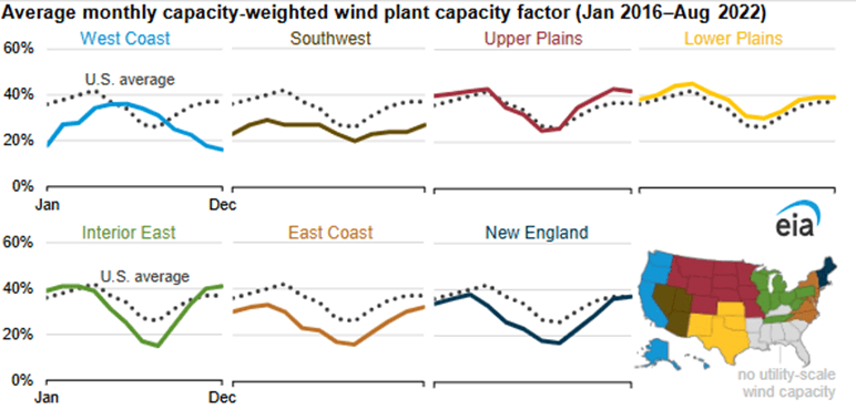


 The best context for understanding decadal temperature changes comes from the world’s sea surface temperatures (SST), for several reasons:


