Meteorologist Cliff Mass explains at his blog El Nino’s Collapse Has Begun. Excerpts in italics with my bolds, added images and ending comment.
The entire character of this winter has been characterized by a strong El Nino.
El Nino impacts have included low snowpack over Washington State, huge snowpack and heavy precipitation over California, and warm temperatures over the Upper Plains states.
However, El Nino’s days are numbered and
its decline is proceeding rapidly right now.
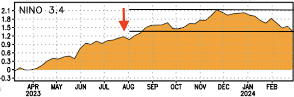
First, consider the critical measure of El Nino: the sea surface temperatures in the central tropical Pacific (see graph above showing the Nino 3.4 area). The warmth of this El Nino peaked in late November (about 2.1°C above normal) and is now declining fairly rapidly (currently at roughly 1.3°C above normal).
But the cooling is really more dramatic than that:
a LOT of cooling has been happening beneath the surface!
To demonstrate this, take a look at subsurface temperatures (the difference from normal) for the lowest 300 m under the surface for a vertical cross-section across the Pacific (below).

On 8 January, there was a substantial warm layer extending about 100 m beneath the surface.
But look at the same cross-section on 27 February.

Wow–what a difference! The warm water has dramatically cooled, with only a thin veneer of warmth evident for much of the Pacific. Rapidly cooling has occurred beneath the surface and this cool water is about to spread to the surface.
If you really want to appreciate the profound cooling take a look at the amount of heat in the upper ocean for the western tropical Pacific (below, the difference from normal is being shown).

A very, very dramatic change has occurred. The heat content of the upper ocean peaked in late November and then plummeted. Declined so much that the water below the surface is now COOLER than normal.
El Nino fans will be further dismayed to learn that models are going for a continuous decline….so much so that they predict a La Nina next year!

My Comment: Why this shift from El Nino to La Nina matters

Global temperatures typically increase during an El Niño episode, and fall during La Niña. El Niño means warmer water spreads further, and stays closer to the surface. This releases more heat into the atmosphere, creating wetter and warmer air.
Air temperatures typically peak a few months after El Niño hits maximum strength, as heat escapes from the sea surface to the atmosphere.
In 2021, the UN’s climate scientists, the IPCC, said the ENSO events which have occurred since 1950 are stronger than those observed between 1850 and 1950. But it also said that tree rings and other historical evidence show there have been variations in the frequency and strength of these episodes since the 1400s.
The IPCC concluded there is no clear evidence that Climate Change™ has affected these events.

12 comments