Meltponds and leads in the Arctic ice cap show evidence of refreezing
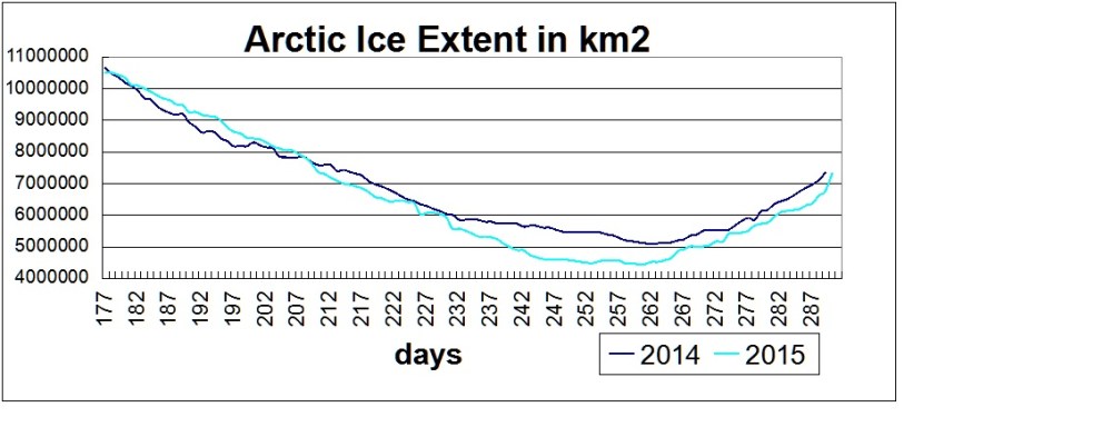
Day 290, October 17, 2015 was a day with several significant events regarding Arctic ice recovery. For the first time since day 218, August 6, ice extent is again over 7M km2. MASIE shows 7.32M compared to NOAA at 7.15M.
The gain yesterday was 557k km2, twice the largest previous increases. As a result, 2015 lags behind 2014 by a single day.
The rate of ice recovery this year since minimum day 260 is 100k km2 per day, 10k greater than 2014, and the highest in the last decade, except for 2013.
The BCE region (Beaufort, Chukchi, East Siberian) is now 105% of 2014 at this date. Hudson and Baffin Bays combined exceed 2014; Kara and Laptev combined are also larger; Greenland Sea is slightly higher. The largest remaining difference is Barents, which melted early and has not recovered. CAA is slowly recovering after the August 2015 storm, and the Central Arctic is down in recent days.
From MASIE (2014 dataset is missing day 290):
| Ice Extents | 2014289 | 2015290 | Ice Extent |
| Region | km2 Diff. | ||
| (0) Northern_Hemisphere | 7328164 | 7321971 | -6193 |
| (1) Beaufort_Sea | 834187 | 887355 | 53169 |
| (2) Chukchi_Sea | 401082 | 447166 | 46084 |
| (3) East_Siberian_Sea | 591126 | 720793 | 129667 |
| (4) Laptev_Sea | 365434 | 697481 | 332047 |
| (5) Kara_Sea | 454119 | 265291 | -188828 |
| (6) Barents_Sea | 266907 | 1589 | -265318 |
| (7) Greenland_Sea | 394133 | 404860 | 10727 |
| (8) Baffin_Bay_Gulf_of_St._Lawrence | 69086 | 113255 | 44168 |
| (9) Canadian_Archipelago | 731010 | 655865 | -75145 |
| (10) Hudson_Bay | 30471 | 17006 | -13465 |
| (11) Central_Arctic | 3188655 | 3110169 | -78486 |
Summary
The comparison with 2014 informs us whether this year will “bend the trend” of recovering ice extent since 2007, and by how much. The pace of refreezing this year is impressive and the end result remains to be seen. My guess: 2015 Average Annual extent will finish as the 3rd highest in the last 10 years, ahead of every year before 2013.


Very high levels of radiation of galactic.

This can disrupt the polar vortex over a longer period of time.
LikeLike
When the solar wind is stronger waves in the stratosphere are weak (in winter).

LikeLike
Abstract
Lidar measurements of atmospheric temperature profiles and aerosol backscatter ratio and depolarization have been carried out at Thule (76.5°N, 68.8°E), Greenland, in the period January – early March 2009. The Lidar, installed at Thule in 1990, is part of the Network for the Detection of Atmospheric Composition Change (NDACC). During winter 2008-2009, Lidar profiles were acquired on a regular basis with a maximum of 5-6 hours of measurements per day, except for a few periods characterized by poor weather conditions or instrumental problems. A total of 44 Lidar temperature profiles between 25 and 70 km were obtained during the measurement campaign. Radiosonde data obtained at the stations of Eureka (79.9°N, 85.9°W) and Alert (82.5°N, 62.3°W) were used to derive temperatures below 25 km. Lidar temperature profiles have permitted to show the evolution of the stratospheric thermal conditions. During the first part of the campaign, in mid-January 2009, the polar vortex was still present above Thule. A polar stratospheric cloud (PSC) of NAT particles was detected on January 17 and 18 between 17 and 19 km. The major sudden stratospheric warming (SSW) was observed during the second half of January. The warming affected the upper stratosphere (~ 40-45 km) first, and then propagated rapidly from the upper to the lower stratosphere. The temporal evolution of the stratospheric temperature was derived at fixed potential temperature levels between 500 and 1500 K. Lidar data show the first signs of the warming at the 1500 K level (~ 42 km) on 22 January, after a week of instrumental problems that prevented from carrying out measurements. After 2-3 days, the warming reached 1000 K (~ 34 km), 900 K (~ 32 km) and 800 K (~ 29 km), and after 5-6 days it reached 600 K (~ 23 km) and 500 K (~ 20 km). Comparison of Lidar data with CIRA model profiles indicates that during the SSW the measured temperature between 25 and 45 km altitude exceeded by 40-50 K the expected CIRA values, reaching a maximum of ~290 K at 40 km. The intensity peak of the SSW was observed between 22 and 24 January. The warming produced an abrupt and irreversible break of the polar vortex. Comparison of 2009 data with Lidar atmospheric temperature measurements obtained during several years between 1994 and 2007 indicates that the 2009 SSW was the strongest event ever observed by the Lidar at Thule.
http://adsabs.harvard.edu/abs/2009AGUFM.A21C0202D
LikeLike
In the case of low solar activity are very important changes in the Earth’s magnetic field because reaches galactic radiation close to the Earth and affects the state of ozone.

LikeLike
Now you have to see the distribution of ozone.

LikeLike
LikeLike
“Since the emission of Carbon tetrachloride has decreased then WHY ozone hole opens up over the Arctic in addition to the ozone hole over the Antaractic? and Why is the ozone hole only over the north and south poles, and not distributed evenly over the Earth’s atmosphere?
The Earth’s magnetic field is the strongest at the polar regions. These regions divert harmful radiations from reaching the surface of the Earth. However, when the Earth’s magnetic field start to decline in the strength as a result of intense bombardment from solar and cosmic radiations more high energy particles can enter the Earth’s magnetosphere and cause this phenomena of ozone depletion.”
https://www.linkedin.com/pulse/20140822214117-97196790-the-decrease-in-the-strength-of-earth-s-magnetic-field-not-carbon-tetrachloride-is-the-reason-for-ozone-depletion
LikeLike
I think that at low temperatures are formed multimeters oxygen, which accelerates the polar vortex (a change in density). Therefore, the tropopause is very little ozone.
“We suggest that most of the ozone in the ozone layer is actually formed by the splitting up of oxygen multimers! We illustrate this mechanism in the schematic in Figure 19.
As in the Chapman mechanism, ultraviolet light can sometimes provide enough energy to break chemical bonds. However, because there are a lot more oxygen atoms in an oxygen multimer than in a regular diatomic oxygen molecule, the ultraviolet light doesn’t have to split the oxygen into individual atoms. Instead, it can split the multimer directly into ozone and oxygen molecules. This doesn’t require as much energy.”

http://globalwarmingsolved.com/2013/11/summary-the-physics-of-the-earths-atmosphere-papers-1-3/#paper2
LikeLike
IIRC the Connollys proposed this explanation of the second phase change in the atmospheric temperature profile. They also showed that the profile shows no effect from IR active gases.
LikeLike
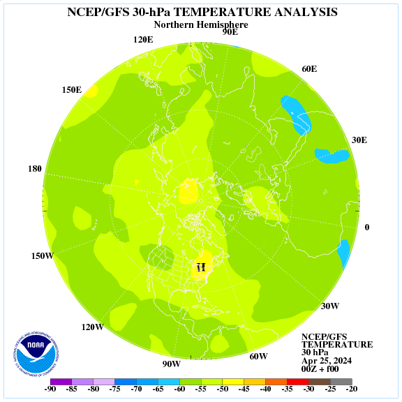
Behind the weather in winter corresponds the polar vortex.
http://earth.nullschool.net/#current/wind/isobaric/70hPa/orthographic=-335.20,88.96,396
LikeLike