A previous post noted the Pacific ice see saw had returned, with Bering Sea slow to recover. The image above shows recovery of Arctic sea ice extent over the month of January 2020. As supported by the table later, the pace of refreezing was slow to begin but has now allowed 2020 to match the 13 year average (2007 to 2019 inclusive). Okohotsk Sea on the left has grown ice extent steadily to be currently at 66% of last March maximum. Bering on the right waffled back and forth but gained strongly the last few days.
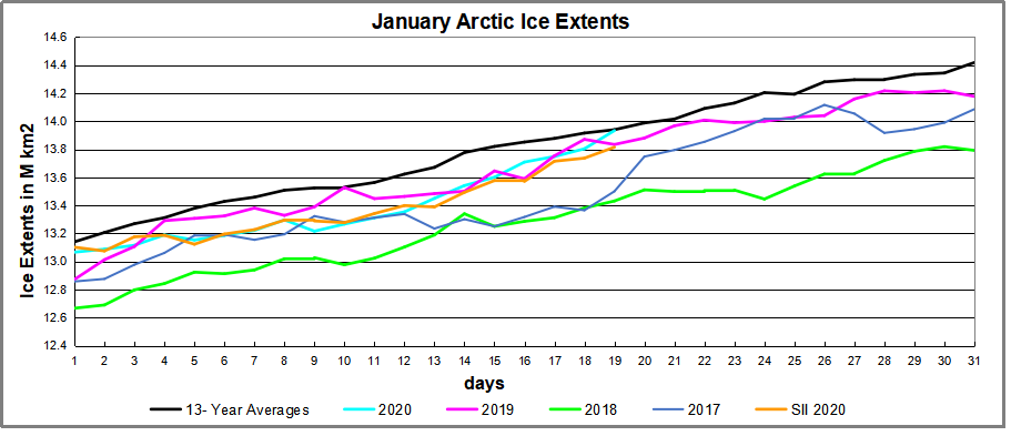
The graph below shows the ice extent growing during January compared to some other years and the 13 year average (2007 to 2019 inclusive).
Note that the NH ice extent 13 year average increases about 1.2M km2 during January, up to 14.4M km2. MASIE 2020 stated with a slower icing rate, dropping 300k km2 lower than average before catching up to reaching the average on January 19. Both 2018 and 2017 were lower at this point, while MASIE and SII are tracking closely together.

The table shows where the ice is distributed compared to average. Deficits in Greenland Sea and Baffin Bay are offset by surpluses in Kara and Barents Seas. At this point the surplus in Okhotsk exceeds the Bering deficit. Going forward, most of the additional ice extent will in the Pacific Seas.
| Region | 2020019 | Day 019 Average | 2020-Ave. | 2018019 | 2020-2018 |
| (0) Northern_Hemisphere | 13933540 | 13939872 | -6332 | 13431421 | 502118 |
| (1) Beaufort_Sea | 1070655 | 1070223 | 432 | 1070445 | 210 |
| (2) Chukchi_Sea | 965972 | 965999 | -27 | 965971 | 1 |
| (3) East_Siberian_Sea | 1087137 | 1087133 | 4 | 1087120 | 18 |
| (4) Laptev_Sea | 897845 | 897842 | 3 | 897845 | 0 |
| (5) Kara_Sea | 933810 | 911944 | 21867 | 902003 | 31807 |
| (6) Barents_Sea | 646750 | 502965 | 143784 | 286684 | 360065 |
| (7) Greenland_Sea | 525324 | 600387 | -75063 | 453112 | 72212 |
| (8) Baffin_Bay_Gulf_of_St._Lawrence | 1155618 | 1245934 | -90317 | 1355009 | -199391 |
| (9) Canadian_Archipelago | 854282 | 853058 | 1225 | 853109 | 1174 |
| (10) Hudson_Bay | 1260192 | 1257480 | 2712 | 1260838 | -646 |
| (11) Central_Arctic | 3239662 | 3203861 | 35801 | 3161866 | 77796 |
| (12) Bering_Sea | 443027 | 570321 | -127294 | 309601 | 133425 |
| (13) Baltic_Sea | 9625 | 52416 | -42791 | 24115 | -14491 |
| (14) Sea_of_Okhotsk | 817160 | 669235 | 147925 | 782693 | 34467 |

Footnote: Interesting comments on January 13 by Dr. Judah Cohen at his blog regarding the Arctic fluctuations. Excerpts in italics with my bolds.
Arctic sea ice extent
The positive AO is conducive to sea ice growth and Arctic sea ice growth rate continues to grow slowly and remains well below normal but higher than recent winters; the weather pattern remains favorable for further sea ice growth. Negative sea ice anomalies exist in three regions: the Bering Sea, around Greenland-Canadian Archipelagos and Barents-Kara Seas. The anomalies in the North Pacific sector have shrunk (Figure 16), and based on model forecasts negative sea ice anomalies in the Bering Sea can shrink further in the next two weeks. Below normal sea ice in and around Greenland and the Canadian Archipelagos may favor a negative winter NAO, though there are no signs of such a scenario. Based on recent research low sea ice anomalies in the Chukchi and Bering seas favors cold temperatures in central and eastern North America while low sea ice in the Barents-Kara seas favor cold temperatures in Central and East Asia, however this topic remains controversial. Recent research has shown that regional anomalies that are most highly correlated with the strength of the stratospheric PV are across the Barents-Kara seas region where low Arctic sea ice favors a weaker winter PV.

Northern Hemisphere Snow Cover
Despite a strongly postive AO snow cover has advanced across Eurasia and is now near decadal means. And if the snowfall forecasts for Europe ever verify it could advance further. Above normal snow cover extent in October, favors a strengthened Siberian high, cold temperatures across northern Eurasia and a weakened polar vortex/negative AO this upcoming winter followed by cold temperatures across the continents of the NH.
Illustration by Eleanor Lutz shows Earth’s seasonal climate changes. If played in full screen, the four corners present views from top, bottom and sides. It is a visual representation of scientific datasets measuring Arctic ice extents and snow cover.


Reblogged this on Climate Collections.
LikeLike