Figure S7. Contributions of forcing and feedbacks to ECS in each model and for the multimodel means. Contributions from the tropical and extratropical portion of the feedback are shown in light and dark shading, respectively. Black dots indicate the ECS in each model, while upward and downward pointing triangles indicate contributions from non-cloud and cloud feedbacks, respectively. Numbers printed next to the multi-model mean bars indicate the cumulative sum of each plotted component. Numerical values are not printed next to residual, extratropical forcing, and tropical albedo terms for clarity. Models within each collection are ordered by ECS.
A previous post here discussed discovering that INMCM4 was the best CMIP5 model in replicating historical temperature records. Additional posts described improvements built into INMCM5, the next generation model included for CMIP6 testing. Later on is a reprint of the temperature history replication and the parameters included in the revised model. This post focuses on a recent report of additional enhancements by the modelers in order to better represent precipitation and extreme rainfall events.
The paper is Influence of various parameters of INM RAS climate model on the results of extreme precipitation simulation by M A Tarasevich and E M Volodin 2019. Excerpts in italics with my bolds.
Modern models of the Earth’s climate can reproduce not only the average climate condition, but also extreme weather and climate phenomena. Therefore, there arises the problem of comparing climate models for observable extreme weather events.
In [1, 2], various extreme weather and climatic situations are considered. According to the paper,27 extreme indices are defined, characterizing different situations with high and low temperatures, with heavy precipitation or with absence of precipitation.
The results of simulation of the extreme indices with the INMCM4 [3] climate model were compared with the results of other models which took part in the CMIP5 project (Coupled Model Intercomparison Project, Phase 5) [2]. The comparison demonstrates that this model performs well for most indices except for those related to daily minimum temperature. For those indices the model shows one of the worst results.
The parameterizations of physical processes in the next model version, INMCM5, were replaced or tuned [4, 5], so that changes in the extreme indices simulation are expected.
The simulation results were compared to the ERA-Interim [6] reanalysis data, which were considered as the observational data for this study. Indices averaged for the 1981–2010 year range were compared. Mann-Whitney test with 1% significance level was used to examine where changes are significant.
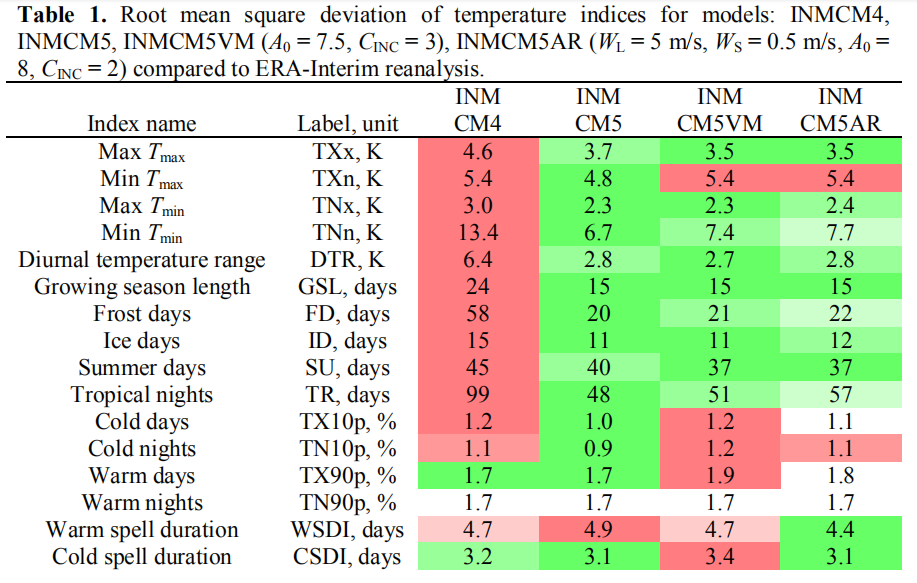
To evaluate the quality of simulation of extreme weather phenomena, the extreme indices were calculated [7] using the results of computations performed by two versions of the INM RAS climate model (INMCM4 and INMCM5) and the ERA Interim reanalysis. We took the root mean square deviation of the index value computed from the modeled and reanalysis data as the measure of simulation quality. The mean is averaged over the land.


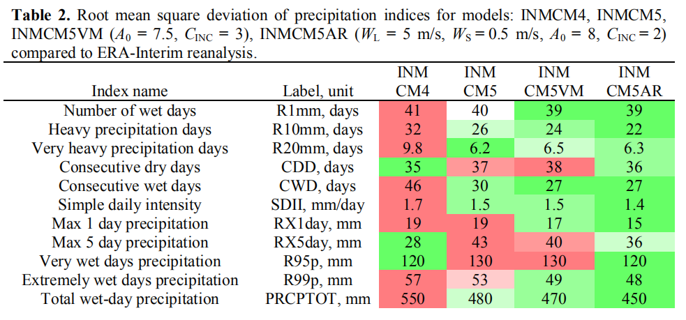
Tables 1 and 2 present the names of extreme indices related to temperature and precipitation, their labels and measurement units, as well as the land only averaged standard deviations for these indices between the ERA-Interim reanalysis and different versions of the INM RAS climate model.
Table 1 shows that the simulation of almost all temperature indices has improved in the INMCM5 compared to INMCM4. In particular, the simulation of the following extreme indices related to the minimum daily temperature improved significantly (by 37–56%): the annual daily minimum temperature (TNn), the number of frost days (FD) and tropical nights (TR), the diurnal temperature range (DTR), and the growing season length (GSL).
[Comment: Note that values in these tables are standard deviations from observations as presented by ERA reanalysis. So for example, growing season length (GSL) varied from mean ERA values by 24 days in INMCM4, but improved to a 15 day differential in INMCM5.]
Table 2 shows that the simulation of the number of heavy (R10mm) and very heavy (R20mm) precipitation days, consecutive wet days (CWD), simple daily intensity (SDII), and total wet-day precipitation (PRCPTOT) noticeably improved in INMCM5. At the same time, the simulation of indices related to the intensity (RX5day) and the amount (R95p) of precipitation on very rainy days became worse.
Improvements Added to INMCM5
To improve the simulation of extreme precipitation by the INMCM5 model, the following physical processes were considered: evaporation of precipitation in the upper atmosphere; mixing of horizontal velocity components due to large-scale condensation and deep convection; air resistance acting on falling precipitation particles.
Both large-scale condensation and deep convection cause vertical motion, which redistributes the horizontal momentum between the nearby air layers. The implementation of mixing due to large-scale condensation was added to the model. For short we will refer to the INMCM5 version with these changes as INMCM5VM (INMCM5 Velocities Mixing).
Since precipitation particles (water droplets or ice crystals) move in the surrounding air, a drag force arises that carries the air along with the particles. This resistance force can be included in the right hand side of the momentum balance equation, which is part of the atmosphere hydrothermodynamic system of equations. Accurate accounting for the effect of this force requires numerical solving of an additional Poisson-type equation. For short, we will refer to the INMCM5 model version with the air resistance and vertical mixing of the horizontal velocity components as INMCM5AR (INMCM5 Air Resistance).

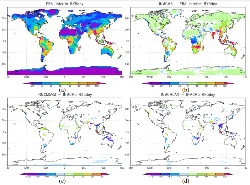
Figure 3. (a) RX5day index values averaged over 1981–2010 according to ERA-Interim data. (b-d) Deviations of the same average obtained from INMCM5, INMCM5VM, and INMCM5AR data. Statistically insignificant deviations are presented as white.
Table 2 shows that the quality of simulation of all precipitation-related extreme indices in INMCM5AR either improved by 3–21 % compared to INMCM5 or remained unchanged.
Figures 2d, 3d show the spatial distribution of the deviations for max 1 day (RX1day) and 5 day (RX5day) precipitation according to INMCM5AR compared to INMCM5. The model with air resistance acting on falling precipitation particles compared to INMCM5 significantly underestimates RX1day and RX5day in South Africa, South and East Asia, and slightly underestimates the indicated extreme indices in Tibet.
Taking into account the air resistance acting on falling precipitation particles significantly reduces the overestimation of RX1day and RX5day observed in INMCM5 in South Africa, South and East Asia, and leads to an improvement in the quality of extreme indices associated with the precipitation amount on very rainy days and their intensity simulation by 9–21 %. At the same time, a significant overestimation of the RX1day and RX5day indices in the Amazon basin and Southeast Asia, as well as their underestimation in West Africa, still remain.
Footnote:
A simple analysis shows if the climate sensitivity estimated by INMCM5 (1.8C per doubling of CO2) would be realized over the next 80 years, it would mean a continuation of the warming over the last 60 years. The accumulated rise in GMT would be 1.2C for the 21st Century, well below the IPCC 1.5C aspiration. See I Want You Not to Panic
Update February 4, 2020
A recent comparison of INMCM5 and other CMIP6 climate models is discussed in the post
Climate Models: Good, Bad and Ugly
Updated with October 25, 2018 Report
A previous analysis Temperatures According to Climate Models showed that only one of 42 CMIP5 models was close to hindcasting past temperature fluctuations. That model was INMCM4, which also projected an unalarming 1.4C warming to the end of the century, in contrast to the other models programmed for future warming five times the past.
 In a recent comment thread, someone asked what has been done recently with that model, given that it appears to be “best of breed.” So I went looking and this post summarizes further work to produce a new, hopefully improved version by the modelers at the Institute of Numerical Mathematics of the Russian Academy of Sciences.

Institute of Numerical Mathematics, Russian Academy of Sciences, Moscow, Russia
A previous post a year ago went into the details of improvements made in producing the latest iteration INMCM5 for entry into the CMIP6 project. That text is reprinted below.
Now a detailed description of the model’s global temperature outputs has been published October 25, 2018 in Earth System Dynamics Simulation of observed climate changes in 1850–2014 with climate model INM-CM5 (Title is link to pdf) Excerpts below with my bolds.

Figure 1. The 5-year mean GMST (K) anomaly with respect to 1850–1899 for HadCRUTv4 (thick solid black); model mean (thick solid red). Dashed thin lines represent data from individual model runs: 1 – purple, 2 – dark blue, 3 – blue, 4 – green, 5 – yellow, 6 – orange, 7 – magenta. In this and the next figures numbers on the time axis indicate the first year of the 5-year mean.
Abstract
Climate changes observed in 1850-2014 are modeled and studied on the basis of seven historical runs with the climate model INM-CM5 under the scenario proposed for Coupled Model Intercomparison Project, Phase 6 (CMIP6). In all runs global mean surface temperature rises by 0.8 K at the end of the experiment (2014) in agreement with the observations. Periods of fast warming in 1920-1940 and 1980-2000 as well as its slowdown in 1950-1975 and 2000-2014 are correctly reproduced by the ensemble mean. The notable change here with respect to the CMIP5 results is correct reproduction of the slowdown of global warming in 2000-2014 that we attribute to more accurate description of the Solar constant in CMIP6 protocol. The model is able to reproduce correct behavior of global mean temperature in 1980-2014 despite incorrect phases of the Atlantic Multidecadal Oscillation and Pacific Decadal Oscillation indices in the majority of experiments. The Arctic sea ice loss in recent decades is reasonably close to the observations just in one model run; the model underestimates Arctic sea ice loss by the factor 2.5. Spatial pattern of model mean surface temperature trend during the last 30 years looks close the one for the ERA Interim reanalysis. Model correctly estimates the magnitude of stratospheric cooling.
Additional Commentary
Observational data of GMST for 1850-2014 used for verification of model results were produced by HadCRUT4 (Morice et al 2012). Monthly mean sea surface temperature (SST) data ERSSTv4 (Huang et al 2015) are used for comparison of the AMO and PDO indices with that of the model. Data of Arctic sea ice extent for 1979-2014 derived from satellite observations are taken from Comiso and Nishio (2008). Stratospheric temperature trend and geographical distribution of near surface air temperature trend for 1979-2014 are calculated from ERA Interim reanalysis data (Dee et al 2011).
Keeping in mind the arguments that the GMST slowdown in the beginning of 21st 6 century could be due to the internal variability of the climate system let us look at the behavior of the AMO and PDO climate indices. Here we calculated the AMO index in the usual way, as the SST anomaly in Atlantic at latitudinal band 0N-60N minus anomaly of the GMST. Model and observed 5 year mean AMO index time series are presented in Fig.3. The well known oscillation with a period of 60-70 years can be clearly seen in the observations. Among the model runs, only one (dashed purple line) shows oscillation with a period of about 70 years, but without significant maximum near year 2000. In other model runs there is no distinct oscillation with a period of 60-70 years but period of 20-40 years prevails. As a result none of seven model trajectories reproduces behavior of observed AMO index after year 1950 (including its warm phase at the turn of the 20th and 21st centuries). One can conclude that anthropogenic forcing is unable to produce any significant impact on the AMO dynamics as its index averaged over 7 realization stays around zero within one sigma interval (0.08). Consequently, the AMO dynamics is controlled by internal variability of the climate system and cannot be predicted in historic experiments. On the other hand the model can correctly predict GMST changes in 1980-2014 having wrong phase of the AMO (blue, yellow, orange lines on Fig.1 and 3).
Conclusions
Seven historical runs for 1850-2014 with the climate model INM-CM5 were analyzed. It is shown that magnitude of the GMST rise in model runs agrees with the estimate based on the observations. All model runs reproduce stabilization of GMST in 1950-1970, fast warming in 1980-2000 and a second GMST stabilization in 2000-2014 suggesting that the major factor for predicting GMST evolution is the external forcing rather than system internal variability. Numerical experiments with the previous model version (INMCM4) for CMIP5 showed unrealistic gradual warming in 1950-2014. The difference between the two model results could be explained by more accurate modeling of stratospheric volcanic and tropospheric anthropogenic aerosol radiation effect (stabilization in 1950-1970) due to the new aerosol block in INM-CM5 and more accurate prescription of Solar constant scenario (stabilization in 2000-2014) in CMIP6 protocol. Four of seven INM-CM5 model runs simulate acceleration of warming in 1920-1940 in a correct way, other three produce it earlier or later than in reality. This indicates that for the year warming of 1920-1940 the climate system natural variability plays significant role. No model trajectory reproduces correct time behavior of AMO and PDO indices. Taking into account our results on the GMST modeling one can conclude that anthropogenic forcing does not produce any significant impact on the dynamics of AMO and PDO indices, at least for the INM-CM5 model. In turns, correct prediction of the GMST changes in the 1980-2014 does not require correct phases of the AMO and PDO as all model runs have correct values of the GMST while in at least three model experiments the phases of the AMO and PDO are opposite to the observed ones in that time. The North Atlantic SST time series produced by the model correlates better with the observations in 1980-2014. Three out of seven trajectories have strongly positive North Atlantic SST anomaly as the observations (in the other four cases we see near-to-zero changes for this quantity). The INMCM5 has the same skill for prediction of the Arctic sea ice extent in 2000-2014 as CMIP5 models including INMCM4. It underestimates the rate of sea ice loss by a factor between the two and three. In one extreme case the magnitude of this decrease is as large as in the observations while in the other the sea ice extent does not change compared to the preindustrial ages. In part this could be explained by the strong internal variability of the Arctic sea ice but obviously the new version of INMCM model and new CMIP6 forcing protocol does not improve prediction of the Arctic sea ice extent response to anthropogenic forcing.
Previous Post: Climate Model Upgraded: INMCM5 Under the Hood
Earlier in 2017 came this publication Simulation of the present-day climate with the climate model INMCM5 by E.M. Volodin et al. Excerpts below with my bolds.
In this paper we present the fifth generation of the INMCM climate model that is being developed at the Institute of Numerical Mathematics of the Russian Academy of Sciences (INMCM5). The most important changes with respect to the previous version (INMCM4) were made in the atmospheric component of the model. Its vertical resolution was increased to resolve the upper stratosphere and the lower mesosphere. A more sophisticated parameterization of condensation and cloudiness formation was introduced as well. An aerosol module was incorporated into the model. The upgraded oceanic component has a modified dynamical core optimized for better implementation on parallel computers and has two times higher resolution in both horizontal directions.
Analysis of the present-day climatology of the INMCM5 (based on the data of historical run for 1979–2005) shows moderate improvements in reproduction of basic circulation characteristics with respect to the previous version. Biases in the near-surface temperature and precipitation are slightly reduced compared with INMCM4 as well as biases in oceanic temperature, salinity and sea surface height. The most notable improvement over INMCM4 is the capability of the new model to reproduce the equatorial stratospheric quasi-biannual oscillation and statistics of sudden stratospheric warmings.

The family of INMCM climate models, as most climate system models, consists of two main blocks: the atmosphere general circulation model, and the ocean general circulation model. The atmospheric part is based on the standard set of hydrothermodynamic equations with hydrostatic approximation written in advective form. The model prognostic variables are wind horizontal components, temperature, specific humidity and surface pressure.
Atmosphere Module
The INMCM5 borrows most of the atmospheric parameterizations from its previous version. One of the few notable changes is the new parameterization of clouds and large-scale condensation. In the INMCM5 cloud area and cloud water are computed prognostically according to Tiedtke (1993). That includes the formation of large-scale cloudiness as well as the formation of clouds in the atmospheric boundary layer and clouds of deep convection. Decrease of cloudiness due to mixing with unsaturated environment and precipitation formation are also taken into account. Evaporation of precipitation is implemented according to Kessler (1969).
In the INMCM5 the atmospheric model is complemented by the interactive aerosol block, which is absent in the INMCM4. Concentrations of coarse and fine sea salt, coarse and fine mineral dust, SO2, sulfate aerosol, hydrophilic and hydrophobic black and organic carbon are all calculated prognostically.

Ocean Module
The oceanic module of the INMCM5 uses generalized spherical coordinates. The model “South Pole” coincides with the geographical one, while the model “North Pole” is located in Siberia beyond the ocean area to avoid numerical problems near the pole. Vertical sigma-coordinate is used. The finite-difference equations are written using the Arakawa C-grid. The differential and finite-difference equations, as well as methods of solving them can be found in Zalesny etal. (2010).
The INMCM5 uses explicit schemes for advection, while the INMCM4 used schemes based on splitting upon coordinates. Also, the iterative method for solving linear shallow water equation systems is used in the INMCM5 rather than direct method used in the INMCM4. The two previous changes were made to improve model parallel scalability. The horizontal resolution of the ocean part of the INMCM5 is 0.5 × 0.25° in longitude and latitude (compared to the INMCM4’s 1 × 0.5°).
Both the INMCM4 and the INMCM5 have 40 levels in vertical. The parallel implementation of the ocean model can be found in (Terekhov etal. 2011). The oceanic block includes vertical mixing and isopycnal diffusion parameterizations (Zalesny et al. 2010). Sea ice dynamics and thermodynamics are parameterized according to Iakovlev (2009). Assumptions of elastic-viscous-plastic rheology and single ice thickness gradation are used. The time step in the oceanic block of the INMCM5 is 15 min.
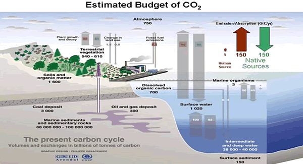
Note the size of the human emissions next to the red arrow.
Carbon Cycle Module
The climate model INMCM5 has а carbon cycle module (Volodin 2007), where atmospheric CO2 concentration, carbon in vegetation, soil and ocean are calculated. In soil, а single carbon pool is considered. In the ocean, the only prognostic variable in the carbon cycle is total inorganic carbon. Biological pump is prescribed. The model calculates methane emission from wetlands and has a simplified methane cycle (Volodin 2008). Parameterizations of some electrical phenomena, including calculation of ionospheric potential and flash intensity (Mareev and Volodin 2014), are also included in the model.
Surface Temperatures
When compared to the INMCM4 surface temperature climatology, the INMCM5 shows several improvements. Negative bias over continents is reduced mainly because of the increase in daily minimum temperature over land, which is achieved by tuning the surface flux parameterization. In addition, positive bias over southern Europe and eastern USA in summer typical for many climate models (Mueller and Seneviratne 2014) is almost absent in the INMCM5. A possible reason for this bias in many models is the shortage of soil water and suppressed evaporation leading to overestimation of the surface temperature. In the INMCM5 this problem was addressed by the increase of the minimum leaf resistance for some vegetation types.
Nevertheless, some problems migrate from one model version to the other: negative bias over most of the subtropical and tropical oceans, and positive bias over the Atlantic to the east of the USA and Canada. Root mean square (RMS) error of annual mean near surface temperature was reduced from 2.48 K in the INMCM4 to 1.85 K in the INMCM5.
Precipitation
In mid-latitudes, the positive precipitation bias over the ocean prevails in winter while negative bias occurs in summer. Compared to the INMCM4, the biases over the western Indian Ocean, Indonesia, the eastern tropical Pacific and the tropical Atlantic are reduced. A possible reason for this is the better reproduction of the tropical sea surface temperature (SST) in the INMCM5 due to the increase of the spatial resolution in the oceanic block, as well as the new condensation scheme. RMS annual mean model bias for precipitation is 1.35mm day−1 for the INMCM5 compared to 1.60mm day−1 for the INMCM4.
Cloud Radiation Forcing
Cloud radiation forcing (CRF) at the top of the atmosphere is one of the most important climate model characteristics, as errors in CRF frequently lead to an incorrect surface temperature.
In the high latitudes model errors in shortwave CRF are small. The model underestimates longwave CRF in the subtropics but overestimates it in the high latitudes. Errors in longwave CRF in the tropics tend to partially compensate errors in shortwave CRF. Both errors have positive sign near 60S leading to warm bias in the surface temperature here. As a result, we have some underestimation of the net CRF absolute value at almost all latitudes except the tropics. Additional experiments with tuned conversion of cloud water (ice) to precipitation (for upper cloudiness) showed that model bias in the net CRF could be reduced, but that the RMS bias for the surface temperature will increase in this case.

A table from another paper provides the climate parameters described by INMCM5.
| Climate Parameters |
Observations |
INMCM3 |
INMCM4 |
INMCM5 |
| Incoming solar radiation at TOA |
341.3 [26] |
341.7 |
341.8 |
341.4 |
| Outgoing solar radiation at TOA |
96–100 [26] |
97.5 ± 0.1 |
96.2 ± 0.1 |
98.5 ± 0.2 |
| Outgoing longwave radiation at TOA |
236–242 [26] |
240.8 ± 0.1 |
244.6 ± 0.1 |
241.6 ± 0.2 |
| Solar radiation absorbed by surface |
154–166 [26] |
166.7 ± 0.2 |
166.7 ± 0.2 |
169.0 ± 0.3 |
| Solar radiation reflected by surface |
22–26 [26] |
29.4 ± 0.1 |
30.6 ± 0.1 |
30.8 ± 0.1 |
| Longwave radiation balance at surface |
–54 to 58 [26] |
–52.1 ± 0.1 |
–49.5 ± 0.1 |
–63.0 ± 0.2 |
| Solar radiation reflected by atmosphere |
74–78 [26] |
68.1 ± 0.1 |
66.7 ± 0.1 |
67.8 ± 0.1 |
| Solar radiation absorbed by atmosphere |
74–91 [26] |
77.4 ± 0.1 |
78.9 ± 0.1 |
81.9 ± 0.1 |
| Direct hear flux from surface |
15–25 [26] |
27.6 ± 0.2 |
28.2 ± 0.2 |
18.8 ± 0.1 |
| Latent heat flux from surface |
70–85 [26] |
86.3 ± 0.3 |
90.5 ± 0.3 |
86.1 ± 0.3 |
| Cloud amount, % |
64–75 [27] |
64.2 ± 0.1 |
63.3 ± 0.1 |
69 ± 0.2 |
| Solar radiation-cloud forcing at TOA |
–47 [26] |
–42.3 ± 0.1 |
–40.3 ± 0.1 |
–40.4 ± 0.1 |
| Longwave radiation-cloud forcing at TOA |
26 [26] |
22.3 ± 0.1 |
21.2 ± 0.1 |
24.6 ± 0.1 |
| Near-surface air temperature, °С |
14.0 ± 0.2 [26] |
13.0 ± 0.1 |
13.7 ± 0.1 |
13.8 ± 0.1 |
| Precipitation, mm/day |
2.5–2.8 [23] |
2.97 ± 0.01 |
3.13 ± 0.01 |
2.97 ± 0.01 |
| River water inflow to the World Ocean,10^3 km^3/year |
29–40 [28] |
21.6 ± 0.1 |
31.8 ± 0.1 |
40.0 ± 0.3 |
| Snow coverage in Feb., mil. Km^2 |
46 ± 2 [29] |
37.6 ± 1.8 |
39.9 ± 1.5 |
39.4 ± 1.5 |
| Permafrost area, mil. Km^2 |
10.7–22.8 [30] |
8.2 ± 0.6 |
16.1 ± 0.4 |
5.0 ± 0.5 |
| Land area prone to seasonal freezing in NH, mil. Km^2 |
54.4 ± 0.7 [31] |
46.1 ± 1.1 |
48.3 ± 1.1 |
51.6 ± 1.0 |
| Sea ice area in NH in March, mil. Km^2 |
13.9 ± 0.4 [32] |
12.9 ± 0.3 |
14.4 ± 0.3 |
14.5 ± 0.3 |
| Sea ice area in NH in Sept., mil. Km^2 |
5.3 ± 0.6 [32] |
4.5 ± 0.5 |
4.5 ± 0.5 |
6.1 ± 0.5 |
Heat flux units are given in W/m^2; the other units are given with the title of corresponding parameter. Where possible, ± shows standard deviation for annual mean value. Source: Simulation of Modern Climate with the New Version Of the INM RAS Climate Model (Bracketed numbers refer to sources for observations)
Ocean Temperature and Salinity
The model biases in potential temperature and salinity averaged over longitude with respect to WOA09 (Antonov et al. 2010) are shown in Fig.12. Positive bias in the Southern Ocean penetrates from the surface downward for up to 300 m, while negative bias in the tropics can be seen even in the 100–1000 m layer.
Nevertheless, zonal mean temperature error at any level from the surface to the bottom is small. This was not the case for the INMCM4, where one could see negative temperature bias up to 2–3 K from 1.5 km to the bottom nearly al all latitudes, and 2–3 K positive bias at levels of 700–1000 m. The reason for this improvement is the introduction of a higher background coefficient for vertical diffusion at high depth (3000 m and higher) than at intermediate depth (300–500m). Positive temperature bias at 45–65 N at all depths could probably be explained by shortcomings in the representation of deep convection [similar errors can be seen for most of the CMIP5 models (Flato etal. 2013, their Fig.9.13)].
Another feature common for many present day climate models (and for the INMCM5 as well) is negative bias in southern tropical ocean salinity from the surface to 500 m. It can be explained by overestimation of precipitation at the southern branch of the Inter Tropical Convergence zone. Meridional heat flux in the ocean (Fig.13) is not far from available estimates (Trenberth and Caron 2001). It looks similar to the one for the INMCM4, but maximum of northward transport in the Atlantic in the INMCM5 is about 0.1–0.2 × 10¹⁵ W higher than the one in the INMCM4, probably, because of the increased horizontal resolution in the oceanic block.
Sea Ice
In the Arctic, the model sea ice area is just slightly overestimated. Overestimation of the Arctic sea ice area is connected with negative bias in the surface temperature. In the same time, connection of the sea ice area error with the positive salinity bias is not evident because ice formation is almost compensated by ice melting, and the total salinity source for these pair of processes is not large. The amplitude and phase of the sea ice annual cycle are reproduced correctly by the model. In the Antarctic, sea ice area is underestimated by a factor of 1.5 in all seasons, apparently due to the positive temperature bias. Note that the correct simulation of sea ice area dynamics in both hemispheres simultaneously is a difficult task for climate modeling.
The analysis of the model time series of the SST anomalies shows that the El Niño event frequency is approximately the same in the model and data, but the model El Niños happen too regularly. Atmospheric response to the El Niño vents is also underestimated in the model by a factor of 1.5 with respect to the reanalysis data.
Conclusion
Based on the CMIP5 model INMCM4 the next version of the Institute of Numerical Mathematics RAS climate model was developed (INMCM5). The most important changes include new parameterizations of large scale condensation (cloud fraction and cloud water are now the prognostic variables), and increased vertical resolution in the atmosphere (73 vertical levels instead of 21, top model level raised from 30 to 60 km). In the oceanic block, horizontal resolution was increased by a factor of 2 in both directions.
The climate model was supplemented by the aerosol block. The model got a new parallel code with improved computational efficiency and scalability. With the new version of climate model we performed a test model run (80 years) to simulate the present-day Earth climate. The model mean state was compared with the available datasets. The structures of the surface temperature and precipitation biases in the INMCM5 are typical for the present climate models. Nevertheless, the RMS error in surface temperature, precipitation as well as zonal mean temperature and zonal wind are reduced in the INMCM5 with respect to its previous version, the INMCM4.
The model is capable of reproducing equatorial stratospheric QBO and SSWs.The model biases for the sea surface height and surface salinity are reduced in the new version as well, probably due to increasing spatial resolution in the oceanic block. Bias in ocean potential temperature at depths below 700 m in the INMCM5 is also reduced with respect to the one in the INMCM4. This is likely because of the tuning background vertical diffusion coefficient.
Model sea ice area is reproduced well enough in the Arctic, but is underestimated in the Antarctic (as a result of the overestimated surface temperature). RMS error in the surface salinity is reduced almost everywhere compared to the previous model except the Arctic (where the positive bias becomes larger). As a final remark one can conclude that the INMCM5 is substantially better in almost all aspects than its previous version and we plan to use this model as a core component for the coming CMIP6 experiment.

Summary
One the one hand, this model example shows that the intent is simple: To represent dynamically the energy balance of our planetary climate system. On the other hand, the model description shows how many parameters are involved, and the complexity of processes interacting. The attempt to simulate operations of the climate system is a monumental task with many outstanding challenges, and this latest version is another step in an iterative development.
Note: Regarding the influence of rising CO2 on the energy balance. Global warming advocates estimate a CO2 perturbation of 4 W/m^2. In the climate parameters table above, observations of the radiation fluxes have a 2 W/m^2 error range at best, and in several cases are observed in ranges of 10 to 15 W/m^2.
We do not yet have access to the time series temperature outputs from INMCM5 to compare with observations or with other CMIP6 models. Presumably that will happen in the future.
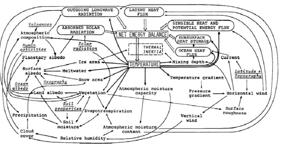
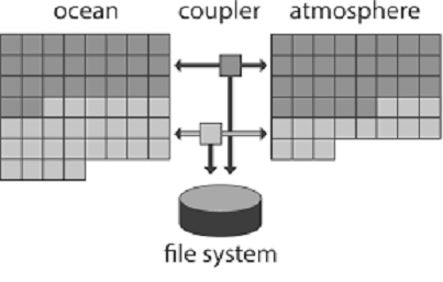
Early Schematic: Flows and Feedbacks for Climate Models
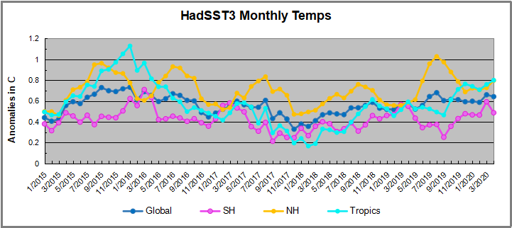
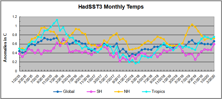
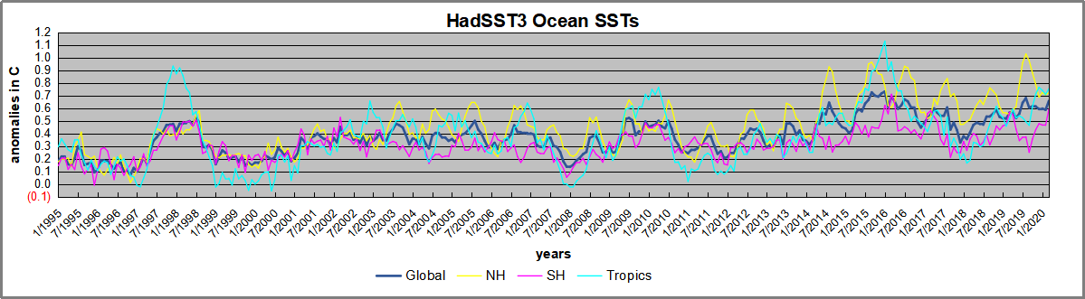
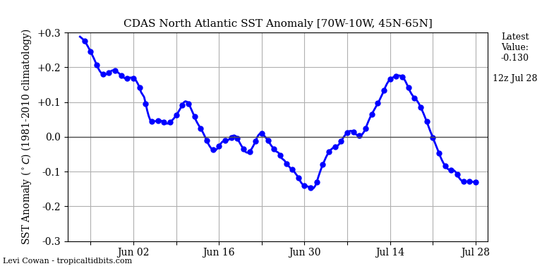
 The best context for understanding decadal temperature changes comes from the world’s sea surface temperatures (SST), for several reasons:
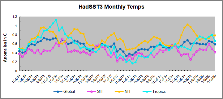 A global cooling pattern is seen clearly in the Tropics since its peak in 2016, joined by NH and SH cycling downward since 2016. In 2019 all regions had been converging to reach nearly the same value in April.
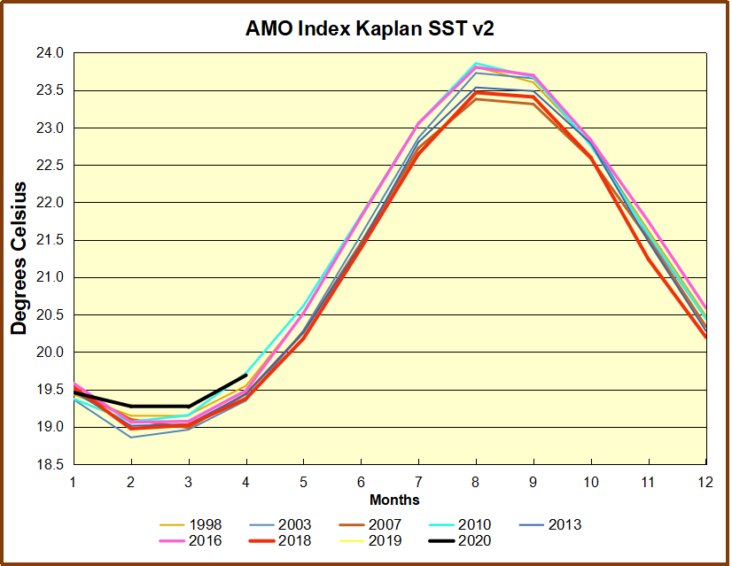
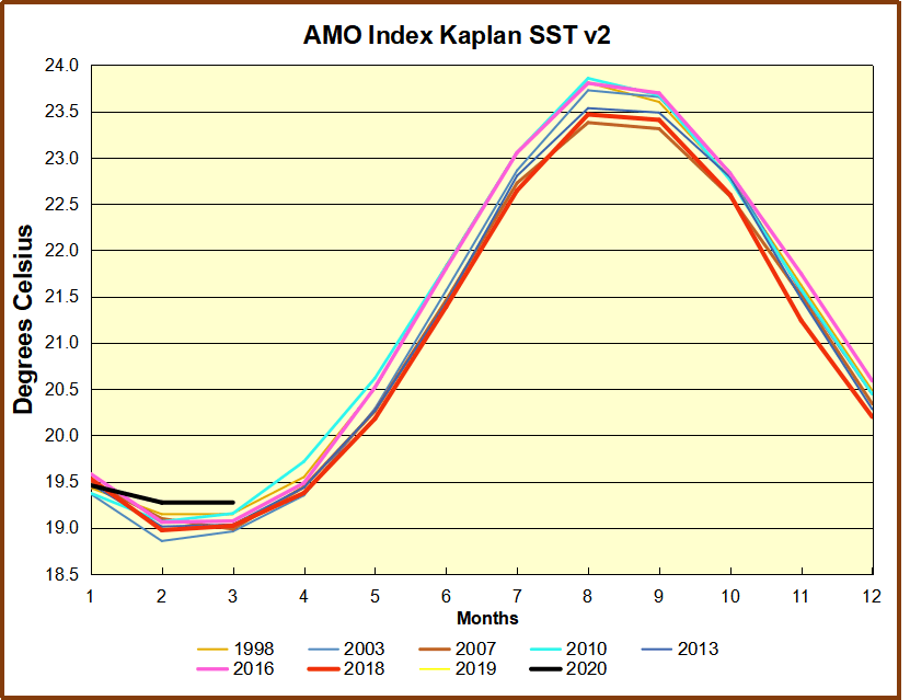
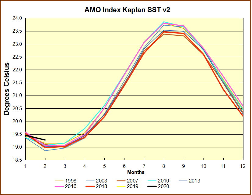
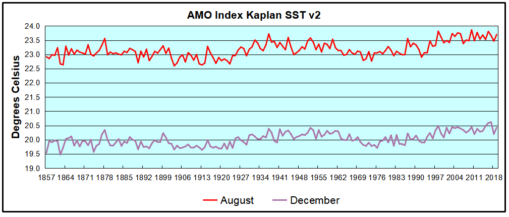 The AMO Index is from from Kaplan SST v2, the unaltered and not detrended dataset. By definition, the data are monthly average SSTs interpolated to a 5×5 grid over the North Atlantic basically 0 to 70N. The graph shows warming began after 1992 up to 1998, with a series of matching years since. Because the N. Atlantic has partnered with the Pacific ENSO recently, let’s take a closer look at some AMO years in the last 2 decades.
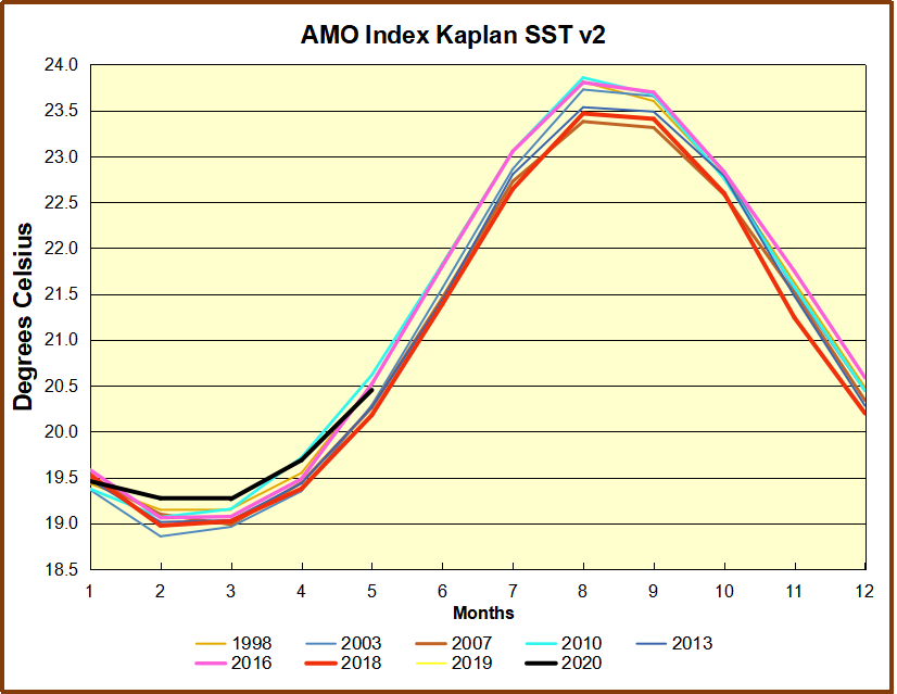 This graph shows monthly AMO temps for some important years. The Peak years were 1998, 2010 and 2016, with the latter emphasized as the most recent. The other years show lesser warming, with 2007 emphasized as the coolest in the last 20 years. Note the red 2018 line is at the bottom of all these tracks. The black line shows that 2020 began slightly warm, then set records for 3 months before dropping below 2016 and 2017.


 Then we have the “doubled CO2” (t1) scenario, where the ERL has been pushed higher up into cooler air layers closer to the tropopause:
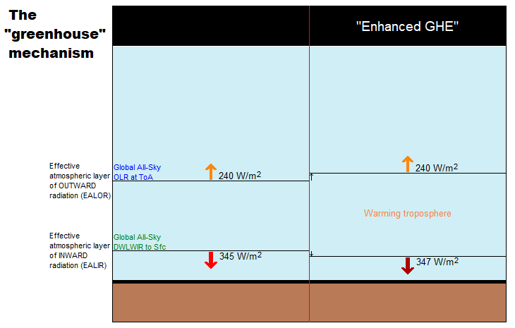
 Figure 5.
 Figure 10.