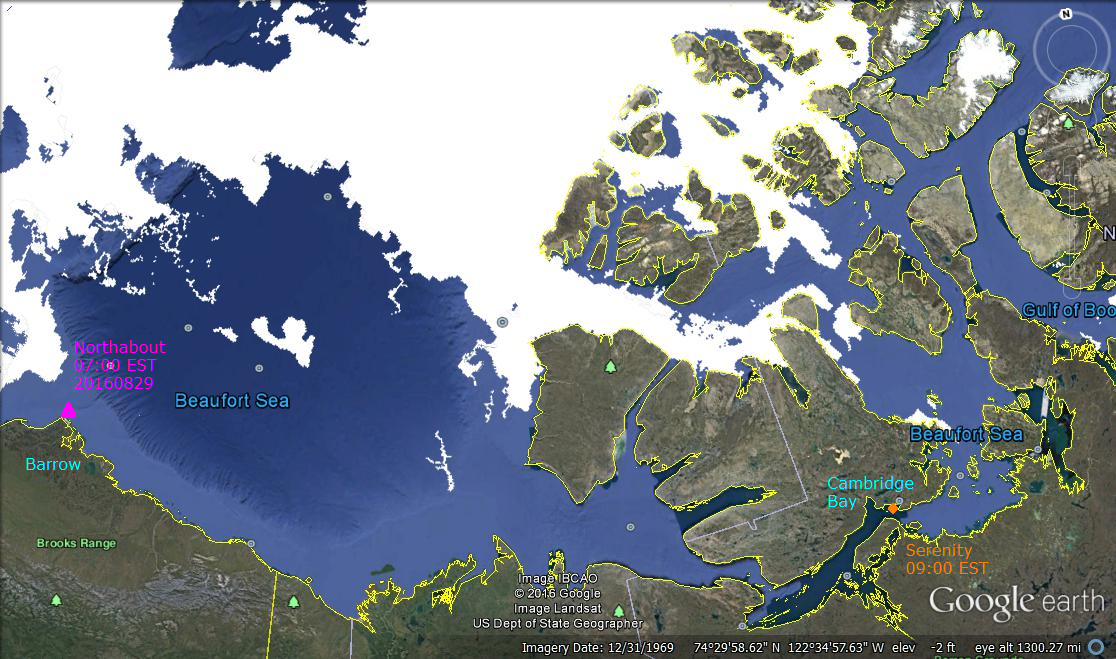
Imagery date refers to Google Earth capture of land forms. Ice extent is for August 27, 2016 from MASIE. Click to zoom in.
Today the tracking shows Northabout is in port at Barrow Alaska, having completed the North East Passage,and preparing for NWP. Serenity is ahead of them, soon to be in port at Cambridge Bay Nunavut.
The man in charge of Serenity, Capt. Birger Vorland, has spent 38 years at sea. Vorland, who is originally from Norway, says the Northwest Passage has special meaning.
“My countryman, Roald Amundsen, did the first transit here between 1903 and 1906,” Vorland says. “We’re going to do it in 32 days and in a lot more comfort.”
The official record of transits through the North West Passage is kept at the Scott Polar Research Institute (here). The listing begins with that first transit by Amundsen and provides details of the 236 crossings recorded through 2015. 13 ships passed through the NWP last year, and the highest number was 29 in 2013.

Cambridge Bay is partway through the NWP and will be home for the new Canadian High Arctic Research Station, pictured in the foreground above. The CHARS campus is expected to be operational in July of 2017 and fully complete by March of 2018.
The image also shows that the southern route through the Archipelago is mostly open water at this time, and the outlook is good for both Serenity and Northabout to achieve their itineraries. The most interesting section of the Nunavut gauntlet lie just ahead of Serenity’s position.
Arctic ice extents are declining as usual approaching the last 2-3 weeks of the annual melt season. Estimates are fluctuating a lot due both to drift ice moving around, and also the difficulty of measuring under cloudy and darkening conditions. The after effects of the recent sizable Arctic cyclone appear in the chart below.
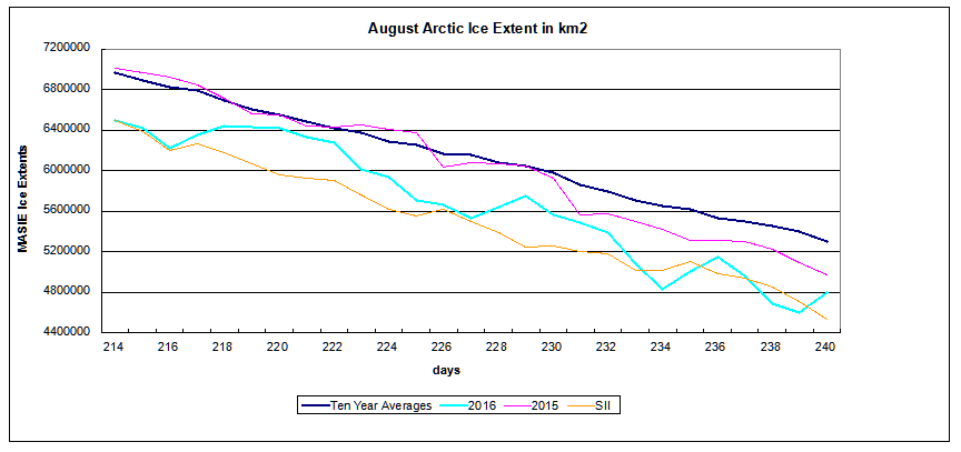
The table below compares 2015 and 2016 at day 240. This year is slightly lower, largely due to Beaufort Sea. Losses elsewhere in Baffin Bay, Greenland Sea, Hudson Bay and E. Siberian are more than offset by surpluses in Chukchi, Laptev and Central Arctic. Note that several seas that are down provide more open water for the ships exploring NWP this year.
Presently 2016 ice decline is running 3 days ahead of 2015.
| Region | 2016240 | 2015240 | Difference |
| (0) Northern_Hemisphere | 4799401 | 4972160 | -172759 |
| (1) Beaufort_Sea | 325257 | 597329 | -272072 |
| (2) Chukchi_Sea | 418423 | 289433 | 128991 |
| (3) East_Siberian_Sea | 237311 | 332785 | -95474 |
| (4) Laptev_Sea | 405208 | 81071 | 324137 |
| (5) Kara_Sea | 28704 | 10133 | 18571 |
| (6) Barents_Sea | 0 | 701 | -701 |
| (7) Greenland_Sea | 120256 | 207476 | -87220 |
| (8) Baffin_Bay_Gulf_of_St._Lawrence | 20965 | 140815 | -119850 |
| (9) Canadian_Archipelago | 258978 | 301788 | -42810 |
| (10) Hudson_Bay | 7308 | 67369 | -60061 |
| (11) Central_Arctic | 2976412 | 2942427 | 33984 |
For more context on Arctic ice extent see Arctic Ice Watch July 31. For background on Polar Ocean Challenge see Laptev Wall and Nunavut Gauntlet. For those who wish to browse Arctic ice in Google Earth, the procedure is simple. Go to MASIE homepage and download the kmz file. Clicking on the file should open it in Google Earth (presuming it is on your computer.) Then you can browse, zoom in and out, and take images.

Celebrity Serenity
I was once told by a fellow cruise passenger not to call our ship a boat. He said in the Navy they knew if you were in a boat it meant something awful had happened to your ship.

The Good Ship Northabout

