With the end of December, Arctic ice is rebuilding in the dark up to its annual maximum before the beginning of dawn in March. Since many of the seas are already at their maximum extents, the coming months will only add about 2M km2 to the approximately 13M km2 of ice in place.

The regrowth of Arctic ice extent was slower than usual until recently. After showing resilience in September, ending higher than 2007, ice growth lagged in October, but has been ramping up toward the averages. The map above shows the deficit of ice is mainly in two marginal seas: Bering in the Pacific and Barents in the Atlantic.
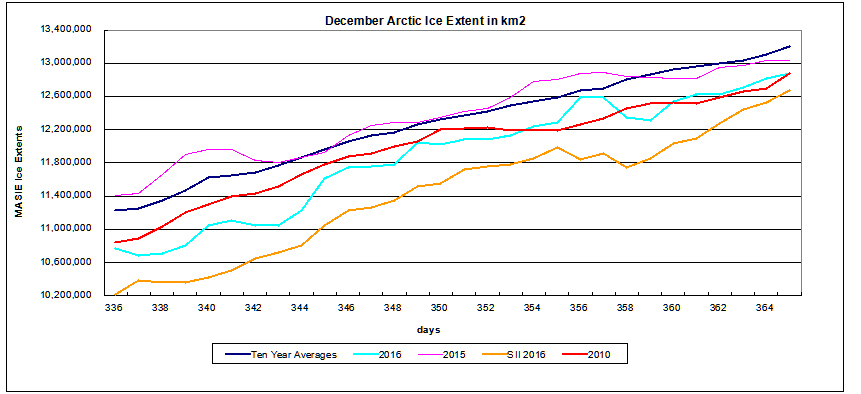
In December, 2016 ice extent has grown by 85k km2 per day, compared to the 10-year average 66k km2 per day. As of Dec. 31, 2016 ice extent is ~3% less than average (2006 to 2015). The chart also shows the variability of ice extent over the years during this month. (Note: Dec. 31, 2016 result is actually day 366, but the 31 days of December are compared properly.)
2015 did have the highest ice recovery rate in the last decade, but ended up just below average. 2010 had the lowest year end extent in the last decade, matched by 2016. 2011 March extent was about average at 14.819 and higher than both 2015 and 2016.
The chart also shows 2016 Sea Ice Index (SII) from NOAA has been lagging behind by ~300k km2, but closing the gap lately.

The table below shows this year compared to average and to 2011 for day 001. Since several years in the dataset were missing day 365, I am making the comparison a day later.
| Region | 2017001 | Day 001 Average |
2016-Ave. | 2007001 | 2016-2006 |
| (0) Northern_Hemisphere | 12857418 | 13223710 | -366293 | 12991512 | -134094 |
| (1) Beaufort_Sea | 1070445 | 1070111 | 334 | 1069711 | 734 |
| (2) Chukchi_Sea | 966006 | 966001 | 5 | 966006 | 0 |
| (3) East_Siberian_Sea | 1087137 | 1087131 | 6 | 1087137 | 0 |
| (4) Laptev_Sea | 897845 | 897835 | 10 | 897845 | 0 |
| (5) Kara_Sea | 875975 | 898092 | -22118 | 928941 | -52966 |
| (6) Barents_Sea | 199976 | 469542 | -269566 | 340349 | -140373 |
| (7) Greenland_Sea | 464142 | 592432 | -128290 | 545210 | -81068 |
| (8) Baffin_Bay_Gulf_of_St._Lawrence | 1153387 | 997051 | 156336 | 863809 | 289578 |
| (9) Canadian_Archipelago | 853214 | 852979 | 235 | 852731 | 483 |
| (10) Hudson_Bay | 1260887 | 1231119 | 29768 | 1217437 | 43450 |
| (11) Central_Arctic | 3085289 | 3216691 | -131403 | 3214432 | -129143 |
| (12) Bering_Sea | 228020 | 506683 | -278663 | 512000 | -283980 |
| (13) Baltic_Sea | 14808 | 31992 | -17184 | 16 | 14793 |
| (14) Sea_of_Okhotsk | 674769 | 376649 | 298120 | 478831 | 195938 |
| (15) Yellow_Sea | 5761 | 12180 | -6419 | 0 | 5761 |
| (16) Cook_Inlet | 5283 | 9040 | -3758 | 15902 | -10619 |
The main deficit to average is in Barents and Greenland Seas on the Atlantic side, and in Bering Sea on Pacific side. The Canadian and Siberian sides are locked in ice, with sizable surpluses in Baffin Bay and Okhotsk Sea.
The Arctic Ice Extent Plateau Continues
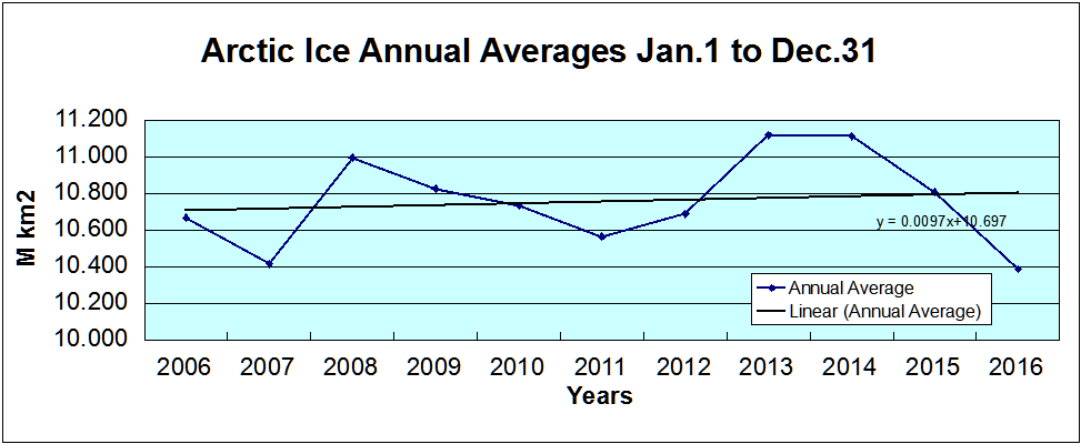
As I have pointed out before, the annual average ice extent is a better indicator of climate variation, since the seasonal changes are so sizable and extents vary with weather activity. By averaging all daily extents over the calendar year, 2016 came in at 10.389M km2 compared to 10.414M in 2007, a virtual tie. And the trendline remains slightly positive, though again, virtually flat.
The data above comes from MASIE, the most accurate Arctic ice dataset with unparalleled resolution at 4km, compared to SII which uses 25km cells. Alarmists are unhappy with MASIE because it shows more ice, and it has been certified as “reasonably consistent” since 2006.
Alarmists are making much ado about 2016 being lower than 2007, and hoping for no future bounces as happened in 2008 and 2013. Will the long-predicted decline finally ensue in 2017, or will the ice make a comeback as before?
No one knows what will happen to Arctic ice.
Except maybe the polar bears.
And they are not talking.
Except, of course, to the admen from Coca-Cola

Summary
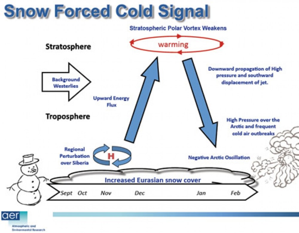
There is no need to panic over Arctic ice this year, or any year. It fluctuates according to its own ocean-ice-atmospheric processes and we can only watch and be surprised since we know so little about how it all works. Judah Cohen at AER thinks the much greater snowfall in October and since will make for a very cold winter. We shall see. It is already adding more mass to the Greenland ice sheet than in previous years.

https://rclutz.wordpress.com/2016/07/06/warm-is-cold-and-down-is-up/

