Dr. Judah Cohen provides a weather outlook based upon his study of the Arctic Oscillation at his blog Arctic Oscillation and Polar Vortex Analysis and Forecast April 19, 2021. Excerpts in italics with my bolds.
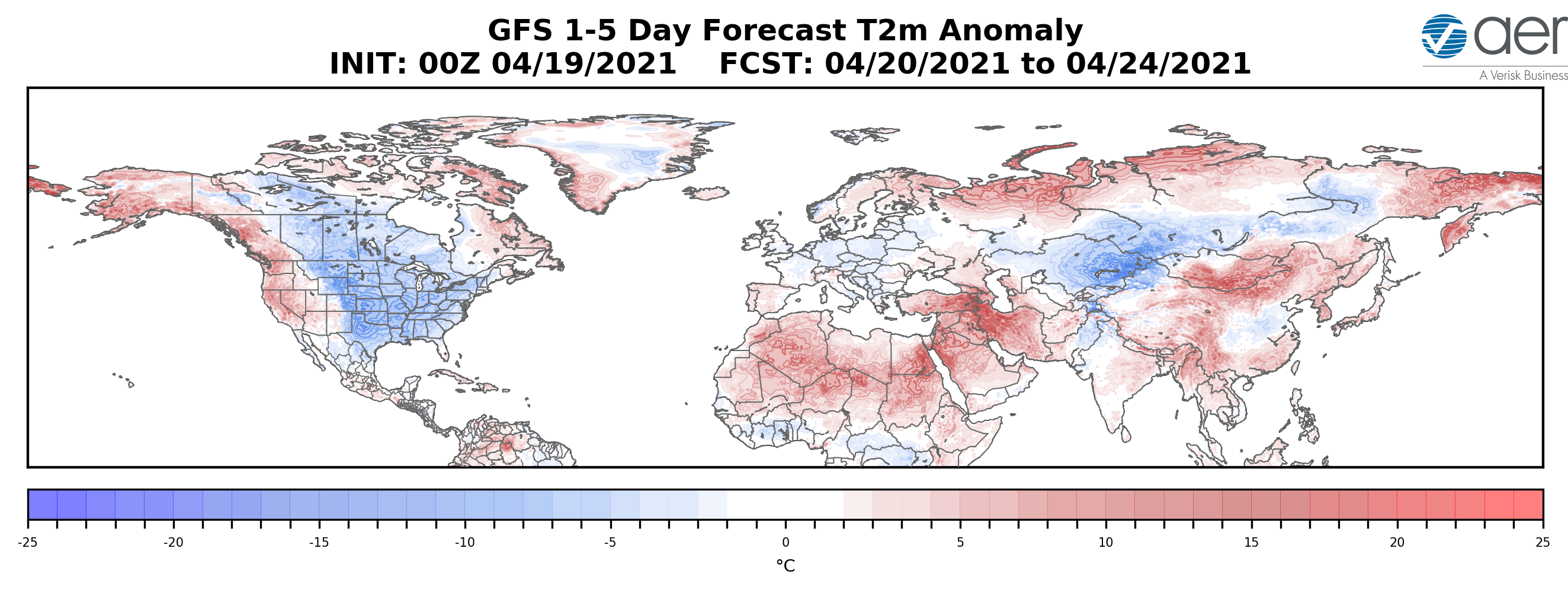
The PV is in its waning days of the 2020/21 cold season and will likely be nearly or completely disappeared by the next blog update. This seems to me to be a clear dynamically assisted Final Warming as vertical Wave Activity Flux (WAFz and is proportional to poleward heat transport) has been active for at least a week now and is predicted to remain active for the next two weeks. A dynamic Final Warming can result in some cooler weather across the mid-latitudes; and in my opinion the snow and possibly record cold temperatures predicted for the Eastern US this week is related to the dynamic Final Warming. The PV is being stretched from Siberia to Canada that creates cross polar flow from Siberia to North America that drives cold air south across Canada and the US east of the Rockies. I do believe that this is a short-term impact only and will not have an influence on the summer weather across North America.
Europe has had an impressively cool April, relative to recent Aprils (probably the coolest April since 2013 and maybe even since 2003), which is directly attributable to Greenland blocking that has also extended into the North Atlantic for much of the month. There are no strong signs that the Greenland blocking will disappear any time soon, and as long as it persists, Europe can experience relatively cool temperatures. I see no obvious signs that the Greenland blocking is tied to PV variability and it is therefore more challenging for me to anticipate how long it will last. But it is likely that the streak of cool weather is dependent on the persistence of the Greenland blocking. If and when the Greenland blocking abates, European temperatures could start to climb.
As noted in previous posts, when cold Arctic air pushes south, it is replaced by warmer air contributing to ice melting. To be clear, sea ice melts primarily because of sunshine directly, and indirectly by intruding sun-warmed water, mostly from the Atlantic by way of Barents Sea. The Arctic in summer daily receives more solar energy than does the equator. Warmer air is a tertiary contributing factor.
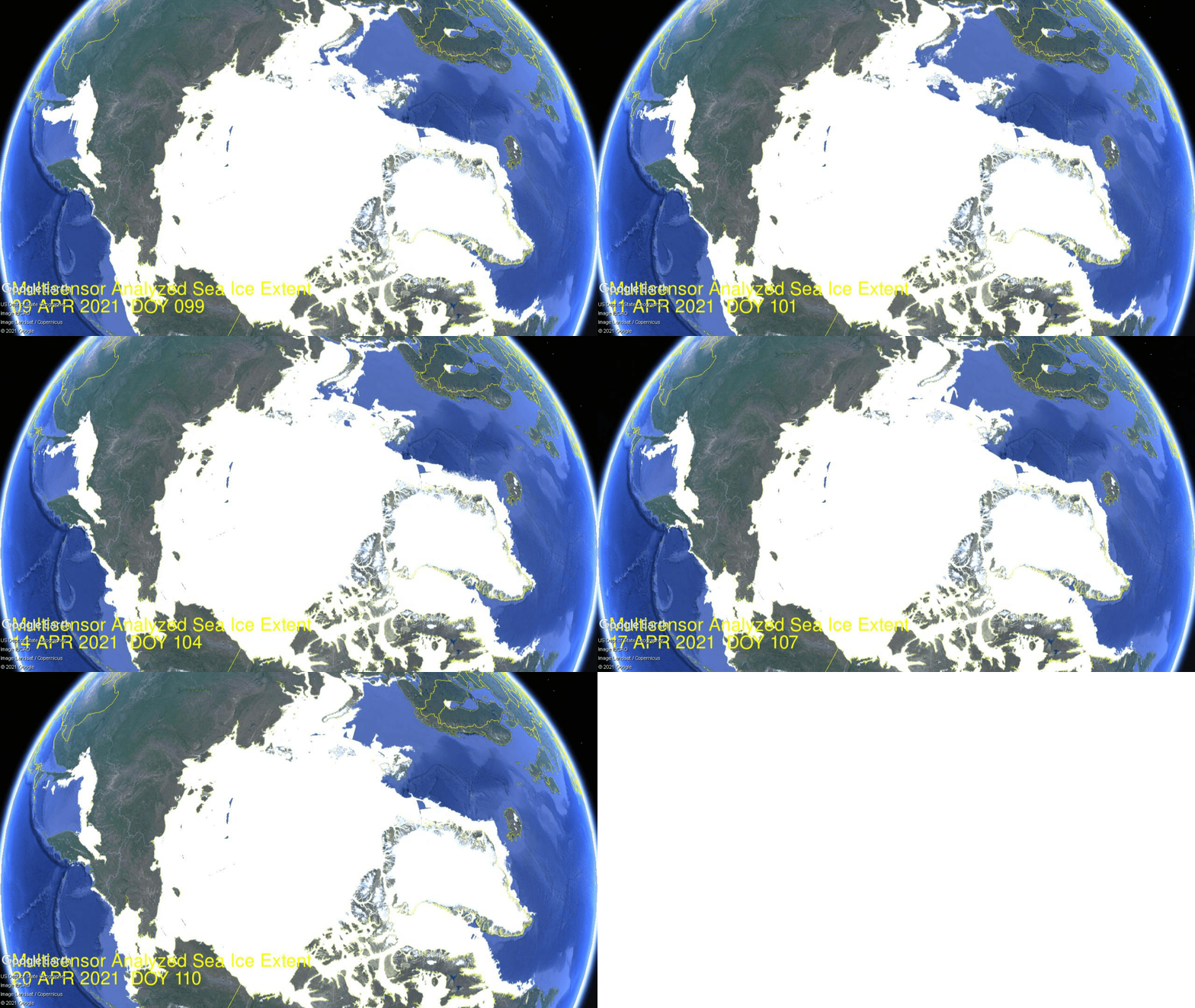
The animation shows Okhotsk upper left lost ~250k km2 of ice extent over the last 10 days. Bering Sea lower left waffled with little change until losing ~60k km2 the last two days. On the Atlantic side, Barents Sea upper right gained ~100k km2 over a week, then lost most of it ending about the same. Greenland Sea middle right lost ~100k km2m, while Baffin Bay lower right waffled and lost very little.
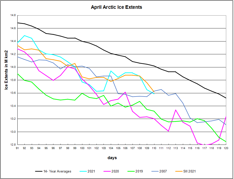
The overall impact on NH sea ice is shown in the graph above. Firstly a drop starting April 10, then recovering April 14 and holding firm to draw near to average, before another drop the last two days.
Background Previous Post Spring 2021: Warm is Cold, and Down is Up
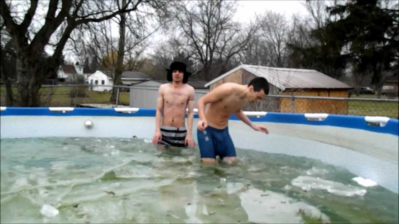
The cold Spring this year is triggering responses turning natural factors upside down and backwards, confusing causes and effects. For example, this article at Science Daily Snow chaos in Europe caused by melting sea-ice in the Arctic. The simplistic appeal to “climate change” is typical: “It is the loss of the Arctic sea-ice due to climate warming that has, somewhat paradoxically, been implicated with severe cold and snowy mid-latitude winters.” In fact, as we shall see below, it is the wavy Polar Vortex causing both cold mid-latitudes from descending Arctic air, and melting ice from intrusions of warmer southern air. Importantly, global warming theory asserts that adding CO2 causes the troposphere to warm and the stratosphere to cool. What we are experiencing this Spring is an unstable Polar vortex due to events of Sudden Stratospheric Warming (SSWs), not cooling.
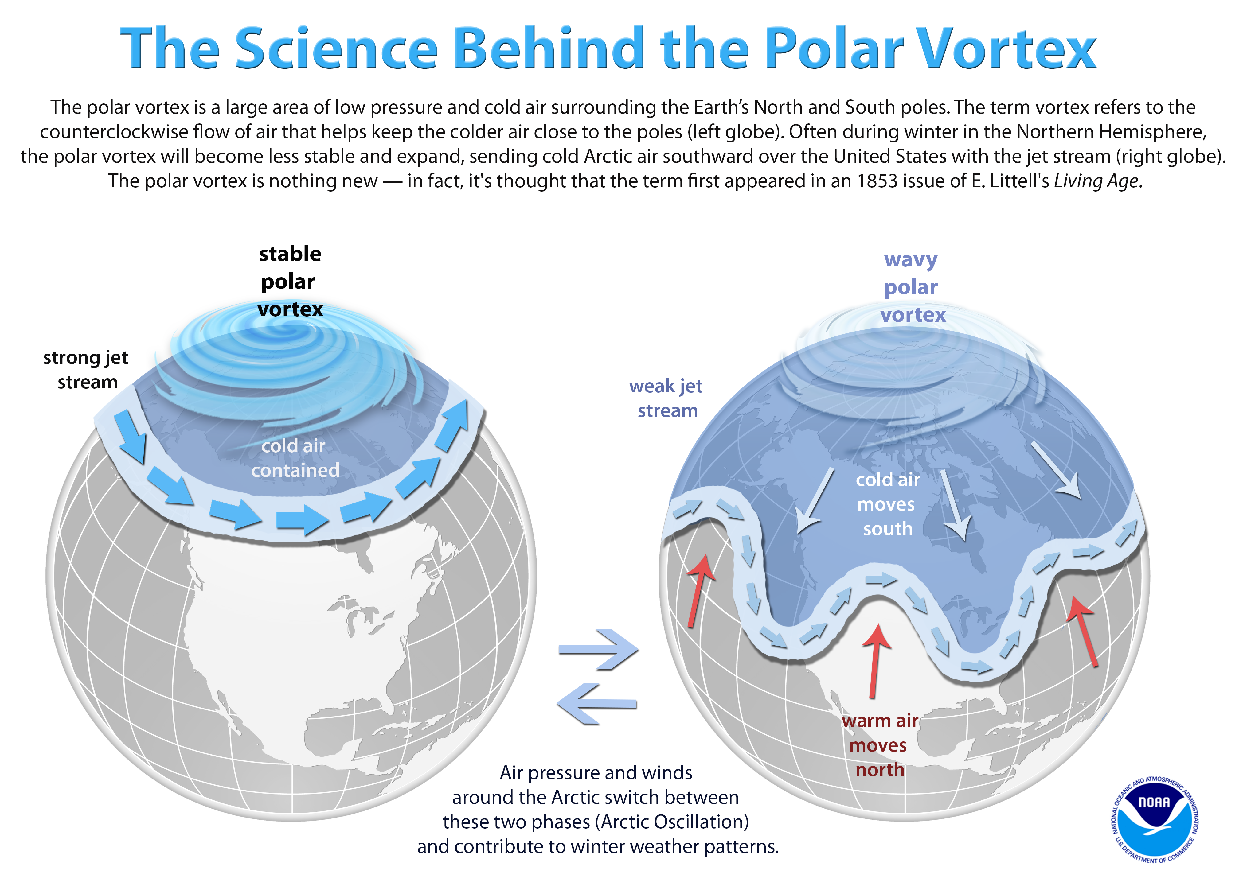
Seasoned meteorologist Judah Cohen of AER shows the mechanism this way:
My colleagues, at AER and at selected universities, and I have found a robust relationship between two October Eurasian snow indices and the large-scale winter hemispheric circulation pattern known as the North Atlantic or Arctic Oscillation pattern (N/AO).
The N/AO is more highly correlated with or explains the highest variance of winter temperatures in eastern North America, Europe and East Asia than any other single or combination of atmospheric or coupled ocean-atmosphere patterns that we know of. Therefore, if we can predict the winter N/AO (whether it will be negative or positive) that provides the best chance for a successful winter temperature forecast in North America but certainly does not guarantee it.
He goes on to say that precipitation is the key, not air temperatures, and ENSO is a driving force:
As long as I have been a seasonal forecaster, I have always considered El Nino/Southern Oscillation (ENSO) as a better predictor of precipitation than temperature across the Eastern US. I think this is supported by the observational or statistical analysis as well as the skill or accuracy of the climate models.
There have been recent modeling studies that demonstrate that El Nino modulates the strength and position of the Aleutian Low that then favors stratospheric warmings and subsequently a negative winter N/AO that are consistent with our own research on the relationship between snow cover and stratospheric warmings. So the influence of ENSO on winter temperatures in the Mid-Atlantic and the Northeast may be greater than I acknowledge or that is represented in our seasonal forecast model.
Summary
As Cohen’s diagram shows, there is an effect from warming, but in the stratosphere. Global warming theory claims CO2 causes warming in the troposphere and cooling in the stratosphere. So whatever is going on, it is not due to CO2.
Cohen’s interview with the Washington Post.

The current situation is described in Cohen’s most recent post at his Arctic Oscillation blog:
The stratospheric PV always disappear in the spring due to the increasing solar radiation in the polar stratosphere. However, during some springs in addition to the radiative warming of the polar stratosphere, there is also dynamic warming of the polar stratosphere due to the absorption of upwelling Wave Activity Flux (WAFz) from the troposphere. This occurred last spring, which did result in a cool May and even some rare snowfall in the Northeastern US. The predicted return of Ural blocking coupled with Northeast Asia/northern North Pacific troughing is conducive to more active WAFz. The latest PV animation (see Figure ii) shows the stratospheric PV filling (weakening) and meandering over the northern Asia in response to the more active WAFz. This could be the beginning of a dynamically assisted Final Warming that could result in a period of cooler temperatures in parts of the mid-latitudes.
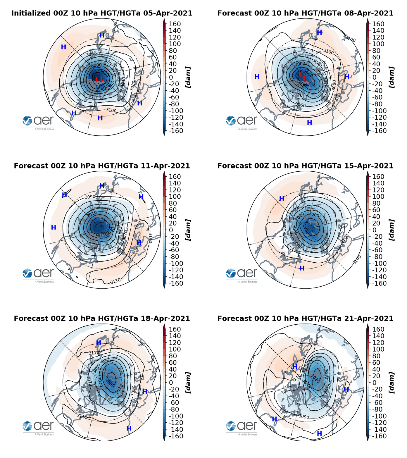
Figure ii. Observed and predicted daily geopotential heights (dam; contours) and anomalies (shading) through April 21, 2021. The forecast is from the 00Z 5 April 2021 GFS ensemble.
Background is at post No, CO2 Doesn’t Drive the Polar Vortex
Reblogged this on Climate Collections.
LikeLike