How Climate Models Get Clouds Wrong

Why Did IMF Disinvite Nobel Laureate?

CO2 Coalition explains.  Nobel Laureate (Physics 2022) Dr. John Clauser was to present a seminar on climate models to the IMF on Thursday and now his talk has been summarily cancelled. According to an email he received last evening, the Director of the Independent Evaluation Office of the International Monetary Fund, Pablo Moreno, had read the flyer for John’s July 25 zoom talk and summarily and immediately canceled the talk. Technically, it was “postponed.”

Dr. Clauser had previously criticized the awarding of the 2021 Nobel Prize for work in the development of computer models predicting global warming and told President Biden that he disagreed with his climate policies. Dr. Clauser has developed a climate model that adds a new significant dominant process to existing models. The process involves the visible light reflected by cumulus clouds that cover, on average, half of the Earth. Existing models greatly underestimate this cloud feedback, which provides a very powerful, dominant thermostatic control of the Earth’s temperature.

More recently, he addressed the Korea Quantum Conference where he stated, “I don’t believe there is a climate crisis” and expressed his belief that “key processes are exaggerated and misunderstood by approximately 200 times.” Dr. Clauser, who is recognized as a climate change skeptic, also became a member of the board of directors of the CO2 Coalition last month, an organization that argues that carbon dioxide emissions are beneficial to life on Earth.

What Difference Clouds Make in Climate Models

Obviously the Clauser presentation is not accessible and I don’t find a link to a publication concerning his treatment of clouds in climate models.  But we can see how the models react to clouds by means of an important paper The Mechanisms of Cloudiness Evolution Responsible for Equilibrium Climate Sensitivity in Climate Model INM-CM4-8 by Evgeny Volodin AGU 03/12/2021.  Excerpts in italics with my bolds.

Abstract

Current climate models demonstrate large discrepancy in equilibrium climate sensitivity (ECS). The effects of cloudiness parameterization changes on the ECS of the INM-CM4-8 climate model were investigated. This model shows the lowest ECS among CMIP6 models. Reasonable changes in the parameterization of the degree of cloudiness yielded ECS variability of 1.8–4.1 K in INM-CM4-8, which was more than half of the interval for the CMIP6 models.

The three principal mechanisms responsible for the increased ECS were increased cloudiness dissipation in warmer climates due to the increased water vapor deficit in the non-cloud fraction of a cell, decreased cloudiness generation in the atmospheric boundary layer in warm climates, and the instantaneous cloud response to CO2 increases due to stratification changes.

Introduction

In CMIP6 the lowest and highest ECS (Equilibrium Climate Sensitivity) values are 1.8 and 5.6 K, respectively (Zelinka et al., 2020). Climate response to some external forcing produces feedbacks. Positive feedback enhances the response to forcing, negative feedback weakens it. Analysis of climate feedback shows that cloud feedback is the principal reason for the broad range of ECS (Zelinka et al., 2020). Clouds (especially low clouds) are significantly reduced with global warming in models with high ECS, resulting in positive feedback. Models with low sensitivity show small cloudiness changes with global warming; some models feature an increase in low clouds in warmer climates, creating a negative feedback.

Clouds produce shortwave and longwave radiative effects. The shortwave cloud radiative effect (SW CRE) is generally negative, because cloudiness reflects solar radiation that would otherwise be absorbed by the climate system. The shortwave effect is usually strongest for low clouds that have high amounts of liquid water and high albedos. The longwave cloud radiative effect (LW CRE) is generally positive, because cloud tops are usually much colder than the surface of the Earth; thus, thermal radiation from the cloud top is much lower than that from the surface. Negative/positive CRE produces cooling/warming from clouds.

The goal of this study is that we turn off some mechanisms responsible for large-scale cloud evolution that lead to increase or decrease ECS, and ECS is changed by the factor of more than 2. The role of a chosen mechanism in decrease or increase of ECS can be clearly seen. At the same time, all model versions show preindustrial climate with systematic biases compared to that for the version used in CMIP6. A realistic way of estimating the impact of change in parameterization on cloud feedback by keeping the cloud mean state realistic in all model versions and running 4xCO2 experiments rather than uniform +4K experiments are used in this study.

Table 1. Summary of Model Versions

Note. Equilibrium climate sensitivity ECS (K), effective radiation forcing ERF (W m−2), climate feedback parameter λ (W m−2 K−1), shortwave cloud radiative feedback СRFSW, longwave cloud radiative feedback СRFLW, net cloud radiative feedback СRFNET (W m−2 K−1) and instantaneous cloud radiative forcing change ΔCREINST (Wm−2).

The ECS estimation method is commonly used in CMIP5 and CMIP6 and was proposed by Gregory et al. (2004). The two model runs performed were the control run, in which all forcings were fixed at preindustrial levels, and the run where the concentration of CO2 in the atmosphere was four times higher than in the control run (4CO2 run). The initial state for both runs was the same and taken from a sufficiently long control run. Each run had a length of 150 years. Subsequently, the global mean difference of GMST and the heat balance at the top of atmosphere (THB) for 4CO2 and the control run were calculated for each model year.

Results of the sensitivity experiments performed with the five climate model versions.

Version 1 shows a very low ECS of 1.8 K due to a low negative climate feedback parameter value of −1.46 W m−2 K−1 (interval from −0.6 to −1.8 W m−2 K−1 for CMIP5 and CMIP6) and a low ERF value of 2.7 W m−2 (intervals of 2.6–4.4 and 2.7–4.3 W m−2 for CMIP5 and CMIP6, respectively, Zelinka et al., 2020). The low ECS was accompanied by mostly negative CRF in both the SW and LW spectral intervals (Figure 2 below).

Figure 2  Shortwave (top), longwave (middle) and net (bottom) cloud radiation feedback (Wm−2 K−1) for model version 1 (purple), 2 (yellow), 3 (red), 4(green), and 5 (blue). Data are multiplied by cosine of latitude.

The parameterization replacement scheme for cloudiness in version 2 dramatically changed all the parameters, and the ECS more than doubled to 3.8 K. ERF increased to 3.8 W m−2, without changes to the radiation code because ΔCREINST changed from −0.88 W m−2 to −0.13 W m−2. Additionally, the climate feedback parameter increased from −1.46 W m−2 K−1 to −1.0 W m−2 K−1. In version 2, global warming was associated with decreased cloudiness at all levels. The net cloud radiative feedback became positive. Version 2 yielded significantly increased net and SW cloud radiative feedbacks at all latitudes compared with version 1. Analysis of the sensitivity experiment results of versions 3–5 helps understand the mechanisms of these significant changes.

Version 3 features a suppressed mechanism of high tropical cloudiness due to decreased convective mass flux and higher ECS than version 2 (4.1 K); however, the change is not very pronounced. The LW CRF in the tropics increases in version 3 compared to version 2. The decrease in SW CRE is not very pronounced; therefore, increased net CRF increases ECS. This confirms our hypothesis that suppressing the decrease in tropical cloudiness should increase ECS and that the impact of this mechanism on ECS is noticeable but not very strong.

ECS is noticeably lower in version 4 (2.9 K) than in version 2. Thus, the mechanism of the decrease in boundary layer cloudiness due to decreased cloudiness generation by boundary layer turbulence is crucial for ECS. SW and LW CRF decreased in version 4 compared to version 2, primarily in the tropics and subtropics.

The mechanism of increased cloud dissipation under global warming conditions was suppressed in version 5, ECS was reduced to 2.5 K, and the climate feedback parameter decreased to −1.56 W m−2 K−1. Additionally, the SW CRF decreased in version 5 compared with version 4, primarily in the tropics and subtropics. In this version, all the mechanisms that decrease clouds with increased temperature, as raised in the previous section, are suppressed. The principal reason for the ECS difference between versions 1 and 5 is the instantaneous adjustment rather than the feedback (see Table 1). ΔCREINST values in versions 1 and 5 were −0.88 and 0.16 W m−2, respectively.

Conclusion

All model versions demonstrate similar model bias values for annual mean CRE, near-surface temperature, and precipitation; thus, determining a relation between present-day climate simulation model quality and ECS is difficult. Version 1 has slightly better quality (because it is a CMIP6 version) due to extensive tuning. The cloudiness scheme used in version 1 contained the dependence of low clouds on stratification. An increase in CO2 leads to more stable stratification and more low clouds and may be the primary cause of the low ECS. Bretherton (2015) and Geoffroy et al. (2017) obtained similar results. The decrease in clouds in warmer climates due to the mixing of cloud air with the unsaturated environment was also stated in a review by Gettelman and Sherwood (2016). Our results confirm those by Bony et al. (2006), Brient and Bony (2012), and others that a significant change in the response of low clouds to global warming leads to significant changes in cloud radiative feedback and ECS.

Comment

The main finding is: If warming increases low clouds, then SW (incoming solar radiation) is reduced, counteracting the warming, in effect a negative feedback.  That is consistent with Clauser’s position.


North Atlantic Warming June 2023

The best context for understanding decadal temperature changes comes from the world’s sea surface temperatures (SST), for several reasons:

  • The ocean covers 71% of the globe and drives average temperatures;
  • SSTs have a constant water content, (unlike air temperatures), so give a better reading of heat content variations;
  • A major El Nino was the dominant climate feature in recent years.

HadSST is generally regarded as the best of the global SST data sets, and so the temperature story here comes from that source. Previously I used HadSST3 for these reports, but Hadley Centre has made HadSST4 the priority, and v.3 will no longer be updated.  HadSST4 is the same as v.3, except that the older data from ship water intake was re-estimated to be generally lower temperatures than shown in v.3.  The effect is that v.4 has lower average anomalies for the baseline period 1961-1990, thereby showing higher current anomalies than v.3. This analysis concerns more recent time periods and depends on very similar differentials as those from v.3 despite higher absolute anomaly values in v.4.  More on what distinguishes HadSST3 and 4 from other SST products at the end. The user guide for HadSST4 is here.

The Current Context

The chart below shows SST monthly anomalies as reported in HadSST4 starting in 2015 through June 2023.  A global cooling pattern is seen clearly in the Tropics since its peak in 2016, joined by NH and SH cycling downward since 2016. 

Note that in 2015-2016 the Tropics and SH peaked in between two summer NH spikes.  That pattern repeated in 2019-2020 with a lesser Tropics peak and SH bump, but with higher NH spikes. By end of 2020, cooler SSTs in all regions took the Global anomaly well below the mean for this period.  In 2021 the summer NH summer spike was joined by warming in the Tropics but offset by a drop in SH SSTs, which raised the Global anomaly slightly over the mean.

Then in 2022, another strong NH summer spike peaked in August, but this time both the Tropic and SH were countervailing, resulting in only slight Global warming, later receding to the mean.   Oct./Nov. temps dropped  in NH and the Tropics took the Global anomaly below the average for this period. After an uptick in December, temps in January 2023 dropped everywhere, strongest in NH, with the Global anomaly further below the mean since 2015.

Now comes El Nino as shown by the upward spike in the Tropics since January, the anomaly doubling from 0.38C to now at 0.87C.  Now in June 2023, all regions rose, especially NH up from 0.7C to now 1.1C, pulling up the global anomaly to a new high for this period. 

A longer view of SSTs

The graph above is noisy, but the density is needed to see the seasonal patterns in the oceanic fluctuations.  Previous posts focused on the rise and fall of the last El Nino starting in 2015.  This post adds a longer view, encompassing the significant 1998 El Nino and since.  The color schemes are retained for Global, Tropics, NH and SH anomalies.  Despite the longer time frame, I have kept the monthly data (rather than yearly averages) because of interesting shifts between January and July.1995 is a reasonable (ENSO neutral) starting point prior to the first El Nino. 

The sharp Tropical rise peaking in 1998 is dominant in the record, starting Jan. ’97 to pull up SSTs uniformly before returning to the same level Jan. ’99. There were strong cool periods before and after the 1998 El Nino event. Then SSTs in all regions returned to the mean in 2001-2. 

SSTS fluctuate around the mean until 2007, when another, smaller ENSO event occurs. There is cooling 2007-8,  a lower peak warming in 2009-10, following by cooling in 2011-12.  Again SSTs are average 2013-14.

Now a different pattern appears.  The Tropics cooled sharply to Jan 11, then rise steadily for 4 years to Jan 15, at which point the most recent major El Nino takes off.  But this time in contrast to ’97-’99, the Northern Hemisphere produces peaks every summer pulling up the Global average.  In fact, these NH peaks appear every July starting in 2003, growing stronger to produce 3 massive highs in 2014, 15 and 16.  NH July 2017 was only slightly lower, and a fifth NH peak still lower in Sept. 2018.

The highest summer NH peaks came in 2019 and 2020, only this time the Tropics and SH were offsetting rather adding to the warming. (Note: these are high anomalies on top of the highest absolute temps in the NH.)  Since 2014 SH has played a moderating role, offsetting the NH warming pulses. After September 2020 temps dropped off down until February 2021.  In 2021-22 there were again summer NH spikes, but in 2022 moderated first by cooling Tropics and SH SSTs, then in October to January 2023 by deeper cooling in NH and Tropics.  

Now in 2023 the Tropics flip from below to above average, and NH starts building up for a summer peak with June already comparable to previous years. In fact, the summer warming peaks in NH have occurred in August or September, so this June number is likely to go higher, perhaps the highest of all.

What to make of all this? The patterns suggest that in addition to El Ninos in the Pacific driving the Tropic SSTs, something else is going on in the NH.  The obvious culprit is the North Atlantic, since I have seen this sort of pulsing before.  After reading some papers by David Dilley, I confirmed his observation of Atlantic pulses into the Arctic every 8 to 10 years.

Contemporary AMO Observations

Through January 2023 I depended on the Kaplan AMO Index (not smoothed, not detrended) for N. Atlantic observations. But it is no longer being updated, and NOAA says they don’t know its future.  So I find only the Hadsst AMO dataset has data through April.  It differs from Kaplan, which reported average absolute temps measured in N. Atlantic.  “Hadsst AMO  follows Trenberth and Shea (2006) proposal to use the NA region EQ-60°N, 0°-80°W and subtract the global rise of SST 60°S-60°N to obtain a measure of the internal variability, arguing that the effect of external forcing on the North Atlantic should be similar to the effect on the other oceans.”  So the values represent differences between the N. Atlantic and the Global ocean.

The chart above confirms what Kaplan also showed.  As August is the hottest month for the N. Atlantic, its varibility, high and low, drives the annual results for this basin.  Note also the peaks in 2010, lows after 2014, and a rise in 2021. An annual chart below is informative:

Note the difference between blue/green years, beige/brown, and purple/red years.  2010, 2021, 2022 all peaked strongly in August or September.  1998 and 2007 were mildly warm.  2016 and 2018 were matching or cooler than the global average.  2023 started out slightly warm, and now in May and June has spiked to match 2010.

The pattern suggests the ocean may be demonstrating a stairstep pattern like that we have also seen in HadCRUT4. 

The purple line is the average anomaly 1980-1996 inclusive, value 0.18.  The orange line the average 1980-202306, value 0.38, also for the period 1997-2012. The red line is 2013-202306, value 0.64. As noted above, these rising stages are driven by the combined warming in the Tropics and NH, including both Pacific and Atlantic basins.

Summary

The oceans are driving the warming this century.  SSTs took a step up with the 1998 El Nino and have stayed there with help from the North Atlantic, and more recently the Pacific northern “Blob.”  The ocean surfaces are releasing a lot of energy, warming the air, but eventually will have a cooling effect.  The decline after 1937 was rapid by comparison, so one wonders: How long can the oceans keep this up? 

Footnote: Why Rely on HadSST4

HadSST is distinguished from other SST products because HadCRU (Hadley Climatic Research Unit) does not engage in SST interpolation, i.e. infilling estimated anomalies into grid cells lacking sufficient sampling in a given month. From reading the documentation and from queries to Met Office, this is their procedure.

HadSST4 imports data from gridcells containing ocean, excluding land cells. From past records, they have calculated daily and monthly average readings for each grid cell for the period 1961 to 1990. Those temperatures form the baseline from which anomalies are calculated.

In a given month, each gridcell with sufficient sampling is averaged for the month and then the baseline value for that cell and that month is subtracted, resulting in the monthly anomaly for that cell. All cells with monthly anomalies are averaged to produce global, hemispheric and tropical anomalies for the month, based on the cells in those locations. For example, Tropics averages include ocean grid cells lying between latitudes 20N and 20S.

Gridcells lacking sufficient sampling that month are left out of the averaging, and the uncertainty from such missing data is estimated. IMO that is more reasonable than inventing data to infill. And it seems that the Global Drifter Array displayed in the top image is providing more uniform coverage of the oceans than in the past.

uss-pearl-harbor-deploys-global-drifter-buoys-in-pacific-ocean

USS Pearl Harbor deploys Global Drifter Buoys in Pacific Ocean


Refresher: GHG Theory and the Tests It Fails

There continues to be a lot of discussions (arguments?) and confusing statements regarding the Green House Gas theory of global warming, in legacy and social media.  So to clear the air I am reposting a concise explanation of the theory and a summary of various independant attempts to find empirical evidence supporting it.

Overview

Many people commenting both for and against reducing emissions from burning fossil fuels assume it has been proven that rising GHGs including CO2 cause higher atmospheric temperatures.  That premise has been tested and found wanting, as this post will describe.  First below is a summary of Global Warming Theory as presented in the scientific literature.  Then follows discussion of several unsuccessful attempts to find evidence of the hypothetical effects from GHGs in the relevant datasets.  Concluding is the alternative theory of climate change deriving from solar and oceanic fluctuations.

Scientific Theory of  Global Warming

The theory is well described in an article by Kristian (okulaer) prefacing his analysis of  “AGW warming” fingerprints in the CERES satellite data.  How the CERES EBAF Ed4 data disconfirms “AGW” in 3 different ways  by okulaer November 11, 2018. Excerpts below with my bolds.  Kristian provides more detailed discussion at his blog (title in red is link).

Background: The AGW Hypothesis

For those of you who aren’t entirely up to date with the hypothetical idea of an “(anthropogenically) enhanced GHE” (the “AGW”) and its supposed mechanism for (CO2-driven) global warming, the general principle is fairly neatly summed up here.

I’ve modified this diagram below somewhat, so as to clarify even further the concept of “the raised ERL (Effective Radiating Level)” – referred to as Ze in the schematic – and how it is meant to ‘drive’ warming within the Earth system; to simply bring the message of this fundamental premise of “AGW” thinking more clearly across.
Then we have the “doubled CO2” (t1) scenario, where the ERL has been pushed higher up into cooler air layers closer to the tropopause:

So when the atmosphere’s IR opacity increases with the excess input of CO2, the ERL is pushed up, and, with that, the temperature at ALL ALTITUDE-SPECIFIC LEVELS of the Earth system, from the surface (Ts) up through the troposphere (Ttropo) to the tropopause, directly connected via the so-called environmental lapse rate, i.e. the negative temperature profile rising up through the tropospheric column, is forced to do the same.

The Expected GHG Fingerprints

How, then, is this mechanism supposed to manifest itself?

Well, as the ERL, basically the “effective atmospheric layer of OUTWARD (upward) radiation”, the one conceptually/mathematically responsible for the All-Sky OLR flux at the ToA, and from now on, in this post, dubbed rather the EALOR, is lifted higher, into cooler layers of air, the diametrically opposite level, the “effective atmospheric layer of INWARD (downward) radiation” (EALIR), the one conceptually and mathematically responsible for the All-Sky DWLWIR ‘flux’ (or “the atmospheric back radiation”) to the surface, is simultaneously – and for the same physical reason, only inversely so – pulled down, into warmer layers of air closer to the surface. This latter concept was explained already in 1938 by G.S. Callendar. Feldman et al., 2015, (as an example) confirm that this is still how “Mainstream Climate Science (MCS)” views this ‘phenomenon’:

The gist being that, when we make the atmosphere more opaque to IR by putting more CO2 into it, “the atmospheric back radiation” (all-sky DWLWIR at sfc) will naturally increase as a result, reducing the radiative heat loss (net LW) from the surface up. And do note, it will increase regardless of (and thus, on top of) any atmospheric rise in temperature, which would itself cause an increase. Which is to say that it will always distinctly increase also RELATIVE TO tropospheric temps (which are, by definition, altitude-specific (fixed at one particular level, like ‘the lower troposphere’ (LT))). That is, even when tropospheric temps do go up, the DWLWIR should be observed to increase systematically and significantly MORE than what we would expect from the temperature rise alone. Because the EALIR moves further down.

Conversely, at the other end, at the ToA, the EALOR moves the opposite way, up into colder layers of air, which means the all-sky OLR (the outward emission flux) should rather be observed to systematically and significantly decrease over time relative to tropospheric temps. If tropospheric temps were to go up, while the DWLWIR at the surface should be observed to go significantly more up, the OLR at the ToA should instead be observed to go significantly less up, because the warming of the troposphere would simply serve to offset the ‘cooling’ of the effective emission to space due to the rise of the EALOR into colder strata of air.

What we’re looking for, then, if indeed there is an “enhancement” of some “radiative GHE” going on in the Earth system, causing global warming, is ideally the following:

OLR stays flat, while TLT increases significantly and systematically over time;
TLT increases systematically over time, but DWLWIR increases significantly even more.
Effectively summed up in this simplified diagram.

Figure 4. Note, this schematic disregards – for the sake of simplicity – any solar warming at work.

However, we also expect to observe one more “greenhouse” signature.

If we expect the OLR at the ToA to stay relatively flat, but the DWLWIR at the sfc to increase significantly over time, even relative to tropospheric temps, then, if we were to compare the two (OLR and DWLWIR) directly, we’d, after all, naturally expect to see a fairly remarkable systematic rise in the latter over the former (refer to Fig.4 above).

Which means we now have our three ways to test the reality of an hypothesized “enhanced GHE” as a ‘driver’ (cause) of global warming.

Three Tests for GHG Warming in the Sky

The null hypothesis in this case would claim or predict that, if there is NO strengthening “greenhouse mechanism” at work in the Earth system, we would observe:

1. The general evolution (beyond short-term, non-thermal noise (like ENSO-related humidity and cloud anomalies or volcanic aerosol anomalies))* of the All-Sky OLR flux at the ToA to track that of Ttropo (e.g. TLT) over time;
2. The general evolution of the All-Sky DWLWIR at the surface to track that of Ttropo (Ts + Ttropo, really) over time;
3. The general evolution of the All-Sky OLR at the ToA and the All-Sky DWLWIR at the surface to track each other over time, barring short-term, non-thermal noise.

* (We see how the curve of the all-sky OLR flux at the ToA differs quite noticeably from the TLT and DWLWIR curves, especially during some of the larger thermal fluctuations (up or down), normally associated with particularly strong ENSO events. This is because there are factors other than pure mean tropospheric temperatures that affect Earth’s final emission flux to space, like the concentration and distribution (equator→poles, surface→tropopause/stratosphere) of clouds, water vapour and aerosols. These may (and do) all vary strongly in the short term, significantly disrupting the normal temperature↔flux (Stefan-Boltzmann) connection, but in the longer term, they display a remarkable tendency to even out, leaving the tropospheric temperature signal as the only real factor to consider when comparing the OLR with Ttropo (TLT). Or not. The “AGW” idea specifically contends, resting on the premise, that these other factors (and crucially also including CO2, of course) do NOT even out over time, but rather accrue in a positive (‘warming’) direction.)

Missing Fingerprint #1

The first point above we have already covered extensively. The combined ERBS+CERES OLR record is seen to track the general progression of the UAHv6 TLT series tightly, both in the tropics and near-globally, all the way from 1985 till today (the last ~33 years), as discussed at length both here and here.

Since, however, in this post we’re specifically considering the CERES era alone, this is how the global OLR matches against the global TLT since 2000:
Figure 5.

This is simply the monthly CERES OLR flux data properly scaled (x0.266), enabling us to compare it more directly to temperatures (W/m2→K), and superimposed on the UAH TLT data. Watch how closely the two curves track each other, beyond the obvious noise. To highlight this striking state of relative congruity, we remove the main sources of visual bias in Fig.5 above. Notice, then, how the red OLR curve, after the 4-year period of fairly large ENSO-events (La Niña-El Niño-La Niña) between 2007/2008 and 2011/2012, when the cyan TLT curve goes both much lower (during the flanking La Niñas) and much higher (during the central El Niño), quickly reestablishes itself right back on top of the TLT curve, just where it used to be prior to that intermediate stretch of strong ENSO influence. And as a result, there is NO gradual divergence whatsoever to be spotted between the mean levels of these two curves, from the beginning of 2000 to the end of 2015.

Missing Fingerprint #2

The second point above is just as relevant as the first one, if we want to confirm (or disconfirm) the reality of an “enhanced GHE” at work in the Earth system. We compare the tropospheric temperatures with the DWLWIRsfc ‘flux’, that is, the apparent atmospheric thermal emission to the surface:

Figure 9. Note how the scaling of the flux (W/m2) values is different close to the surface than at the ToA. Here at the DWLWIR level, down low, we divide by 5 (x0.2), while at the OLR level, up high, we divide by 3.76 (x0.266).

We once again observe a rather close match overall. At the very least, we can safely say that there is no evidence whatsoever of any gradual, systematic rise in DWLWIR over the TLT, going from 2000 to 2018. If we plot the difference between the two curves in Fig.9 to obtain the “DWLWIR residual”, this fact becomes all the more evident:

Figure 10.

Remember now how the idea of an “enhanced GHE” requires the DWLWIR to rise significantly more than Ttropo (TLT) over time, and that its “null hypothesis” therefore postulates that such a rise should NOT be seen. Well, do we see such a rise in the plot above? Nope. Not at all. Which fits in perfectly with the impression we got at the ToA, where the TLT-curve was supposed to rise systematically up and away from the OLR-curve over time, but didn’t – no observed evidence there either of any “enhanced GHE” at work.

Missing Fingerprint #3

Finally, the third point above is also pretty interesting. It is simply to verify whether or not the CERES EBAF Ed4 ‘radiation flux’ data products are indeed suggesting a strengthening of some radiatively defined “greenhouse mechanism”. We sort of know the answer to this already, though, from going through points 1 and 2 above. Since neither the OLR at the ToA nor the DWLWIR at the surface deviated meaningfully from the UAHv6 TLT series (the same one used to compare with both, after all), we expect rather by necessity that the two CERES ‘flux products’ also shouldn’t themselves deviate meaningfully overall from one another. And, unsurprisingly, they don’t:

Figure 14.  Difference plot (“DWLWIR residual”)

Again, it is so easy here to allow oneself to be fooled by the visual impact of that late – obviously ENSO-related – peak, and, in this case, also a definite ENSO-based trough right at the start (you’ll plainly recognise it in Fig.14); another perfect example of how one’s perception and interpretation of a plot is directly affected by “the end-point bias”. Don’t be fooled:

If we expect the OLR at the ToA to stay relatively flat, but the DWLWIR at the sfc to increase significantly over time, even relative to tropospheric temps, then, if we were to compare the two (OLR and DWLWIR) directly, we’d […] naturally expect to see a fairly remarkable systematic rise in the latter over the former (refer to Fig.4 above).

Looking at Fig.14, and taking into account the various ENSO states along the way, does such a “remarkable systematic rise” in DWLWIR over OLR manifest itself during the CERES era?

I’m afraid not …

Five Lines of Evidence Against GHG Warming Hypothesis

The above analysis showing lack of GHG warming in the CERES data is added to four other atmospheric heat radiation studies.

1. In 2004 Ferenc MIskolczi studied the radiosonde datasets and found that the optical density at the top of the troposphere does not change with increasing CO2, since reducing H2O maintains optimal radiating efficiency.  His publication was suppressed by NASA, and he resigned from his job there. He has elaborated on his findings in publications as recently as 2014. See:  The Curious Case of Dr. Miskolczi

2.  Ronan and Michael Connolly  studied radiosonde data and concluded in 2014:

“It can be seen from the infra-red cooling model of Figure 19 that the greenhouse effect theory predicts a strong influence from the greenhouse gases on the barometric temperature profile. Moreover, the modeled net effect of the greenhouse gases on infra-red cooling varies substantially over the entire atmospheric profile.

However, when we analysed the barometric temperature profiles of the radiosondes in this paper, we were unable to detect any influence from greenhouse gases. Instead, the profiles were very well described by the thermodynamic properties of the main atmospheric gases, i.e., N 2 and O 2 , in a gravitational field.”

While water vapour is a greenhouse gas, the effects of water vapour on the temperature profile did not appear to be related to its radiative properties, but rather its different molecular structure and the latent heat released/gained by water in its gas/liquid/solid phase changes.

For this reason, our results suggest that the magnitude of the greenhouse effect is very small, perhaps negligible. At any rate, its magnitude appears to be too small to be detected from the archived radiosonde data.” Pg. 18 of referenced research paper

See:  The Physics Of The Earth’s Atmosphere I. Phase Change Associated With Tropopause

3.  An important proof against the CO2 global warming claim was included in John Christy’s testimony 29 March 2017 at the House Committee on Science, Space and Technology. The text and diagram below are from that document which can be accessed here.

IPCC Assessment Reports show that the IPCC climate models performed best versus observations when they did not include extra GHGs and this result can be demonstrated with a statistical model as well.

Figure 5. Simplification of IPCC AR5 shown above in Fig. 4. The colored lines represent the range of results for the models and observations. The trends here represent trends at different levels of the tropical atmosphere from the surface up to 50,000 ft. The gray lines are the bounds for the range of observations, the blue for the range of IPCC model results without extra GHGs and the red for IPCC model results with extra GHGs.The key point displayed is the lack of overlap between the GHG model results (red) and the observations (gray). The nonGHG model runs (blue) overlap the observations almost completely.

4. 2021 Finding from William Happer

The updating of this previous post is timely following on Dr. William Happer’s additional test of Global Warming Theory, the notion that rising CO2 causes dangerous warming of earth’s climate. A synopsis of that presentation is at Climate Change and CO2 Not a Problem.  For the purpose of this discussion I will add at the end Happer’s finding that additional CO2 (from any and all sources) shows negligible effect in the radiative profile of the atmosphere.

The full discussion of this slide is in the linked synopsis at the top.  In summary here, Happer points to the black line of CO2 infrared absorption at 400 ppm, compared to CO2 IR absorption at 800 ppm.

The important point here is the red line. This is what Earth would radiate to space if you were to double the CO2 concentration from today’s value. Right in the middle of these curves, you can see a gap in spectrum. The gap is caused by CO2 absorbing radiation that would otherwise cool the Earth. If you double the amount of CO2, you don’t double the size of that gap. You just go from the black curve to the red curve, and you can barely see the difference. The gap hardly changes.

The message I want you to understand, which practically no one really understands, is that doubling CO2 makes almost no difference.

An Alternative Theory of Natural Climate Change

Dan Pangburn is a professional engineer who has synthesized the solar and oceanic factors into a mathematical model that correlates with Average Global Temperature (AGT). On his blog is posted a monograph Cause of Global Climate Change explaining clearly his thinking and the maths.  I provided a post with some excerpts and graphs as a synopsis of his analysis, in hopes others will also access and appreciate his work on this issue.  See  Quantifying Natural Climate Change

Footnote on the status of an hypothetical effect too small to be measured:  Bertrand Russell’s teapot

Postscript:  For an explanation why CO2 has negligible effect on thermal properties of the atmosphere, and why all W/m2 are not created equal, see: Light Bulbs Disprove Global Warming

New 2023 INMCM RAS Climate Model First Results

Previous posts (linked at end) discuss how the climate model from RAS (Russian Academy of Science) has evolved through several versions. The interest arose because of its greater ability to replicate the past temperature history. The model is part of the CMIP program which will soon go the next step to CMIP7, and is one of the first to test with a new climate simulation.

This synopsis is made possible thanks to the lead author, Evgeny M. Volodin, providing me with a copy of the article published May 11, 2023 in Izvestiya, Atmospheric and Oceanic Physics. Those with institutional research credentials can access the paper at Simulation of Present-Day Climate with the INMCM60 Model by E. M. Volodin, et al. (2023). Excerpts are in italics with my bolds and added images and comment.

Abstract

A simulation of the present-day climate with a new version of the climate model developed at the Institute of Numerical Mathematics of the Russian Academy of Sciences (INM RAS) is considered. This model differs from the previous version by a change in the cloud and condensation scheme, which leads to a higher sensitivity to the increase in СО2. The changes are also included in the calculation of aerosol evolution, the aerosol indirect effect, land snow, atmospheric boundary-layer parameterization, and some other schemes.

The model is capable of reproducing near-surface air temperature, precipitation, sea-level pressure, cloud radiative forcing, and other parameters better than the previous version. The largest improvement can be seen in the simulation of temperature in the tropical troposphere and at the polar tropopause and surface temperature of the Southern Ocean. The simulation of climate changes in 1850 2021 by the two model versions is discussed.

Introduction

A new version has been developed on the basis of the climate system model described in [1]. It was shown [2] that introducing changes only to the cloud parameterization would produce climate models with different equilibrium sensitivities to a doubling of СО2, in a range of 1.8 to 4.1 K. The INMCM48 version has the lowest sensitivity of 1.8 K among Coupled Model Intercomparison Project Phase 6 (CMIP6) models. The natural question then arises as to how parameterization changes that increase the equilibrium sensitivity affect the simulation of modern climate and of its changes observed in recent decades.

The INMCM48 version simulates modern climate quite well, but it has some systematic biases common to many of the current climate models, and biases specific only to this model. For example, most climate models overestimate surface temperatures and near surface air temperatures at southern midlatitudes and off the east coast of the tropical Pacific and Atlantic oceans and underestimate surface air temperatures in the Arctic (see, e.g., [3]). A typical error of many current models, as well as of INMCM48, is the cold polar tropopause and the warm tropical tropopause, resulting in an overestimation of the westerlies in the midlatitude stratosphere. Possible sources of such systematic biases are the errors in the simulation of cloud amount and optical properties.

In the next version, therefore, changes were first made in cloud parameterization. Furthermore, the INMCM48 exhibited systematic biases specific solely to it. These are, for example, the overestimation of sea-level pressure, as well as of geopotential at any level in the troposphere, over the North Pacific. The likely reason for such biases seems to be related to errors in the heat sources located southward, over the tropical Pacific.

In this study, it is shown how changes in physical parameterizations,
including clouds, affect systematic biases in the simulation of
modern climate and its changes observed in recent decades.

Model and Numerical Experiments

The INMCM60 model, like the previous INMCM48 [1], consists of three major components: atmospheric dynamics, aerosol evolution, and ocean dynamics. The atmospheric component incorporates a land model including surface, vegetation, and soil. The oceanic component also encompasses a sea-ice evolution model. Both versions in the atmosphere have a spatial 2° × 1° longitude-by-latitude resolution and 21 vertical levels up to 10 hPa. In the ocean, the resolution is 1° × 0.5° and 40 levels.

The following changes have been introduced into the model
compared to INMCM48.

Parameterization of clouds and large-scale condensation is identical to that described in [4], except that tuning parameters of this parameterization differ from any of the versions outlined in [3], being, however, closest to version 4. The main difference from it is that the cloud water flux rating boundary-layer clouds is estimated not only for reasons of boundary-layer turbulence development, but also from the condition of moist instability, which, under deep convection, results in fewer clouds in the boundary layer and more in the upper troposphere. The equilibrium sensitivity of such a version to a doubling of atmospheric СО2 is about 3.3 K.

The aerosol scheme has also been updated by including a change in the calculation of natural emissions of sulfate aerosol [5] and wet scavenging, as well as the influence of aerosol concentration on the cloud droplet radius, i.e., the first indirect effect [6]. Numerical values of the constants, however, were taken to be a little different from those used in [5]. Additionally, the improved scheme of snow evolution taking into account refreezing and the calculation of the snow albedo [7] were introduced to the model. The calculation of universal functions in the atmospheric boundary layer in stable stratification has also been changed: in the latest model version, such functions assume turbulence at even large gradient Richardson numbers [8].

A numerical model experiment to simulate a preindustrial climate was run for
180 years,
not including the 200 years when equilibrium was reached.

All climate forcings in this experiment were held at their 1850 level. Along with a preindustrial experiment, a numerical experiment was run to simulate climate change in 1850–2029, for which forcings for 1850–2014 were prescribed consistent with observational estimates [9], while forcings for 2015–2029 were set according to the Shared Socioeconomic Pathway (SSP3-7.0) scenario [10].

To verify the simulation of present-day climate, the data from the experiment with a realistic forcing change for 1985–2014 were used and compared against the European Centre for Medium-Range Weather Forecasts (ECMWF) Reanalysis fifth generation (ERA5) data [11], the Global Precipitation Climatology Project, version 2.3 (GPCP 2.3) precipitation data [12], and the Clouds and the Earth’s Radiant Energy System (CERES) Energy Balanced and Fitted Edition 4.1 (CERES-EBAF 4.1) top-of-atmosphere (TOA) outgoing radiation fluxes [13].

The root-mean-square deviation of the annual and monthly averages of modeled and observed fields was used as a measure for the deviation of model data from observations, for which the observed fields were interpolated into a model grid. For calculating the sea-level pressure and 850-hPa temperature errors, grid points with a height over 1500 m were excluded. The modeled surface air temperatures were compared with the Met Office Hadley Center/Climatic Research Unit version 5  (HadCRUT5) dataset [14].

Results

Below are some results of the present-day climate simulation. Because changes in the model were introduced mainly into the scheme of atmospheric dynamics and land surface and there were no essential changes in the oceanic component, we shall restrict our discussion to atmospheric dynamics.


Table 1 demonstrates that the norms of errors in most fields were reduced. Changing the calculation of cloud cover and properties has improved the cloud radiative forcing, and the norm of errors for both longwave and shortwave forcing decreased by 10–20% in the new version compared to its predecessor. The global average of short-wave cloud radiative forcing is –47.7 W/m2 in the new version, –40.5 W/m2 in the previous version, and about –47 W/m2 in CERES-EBAF. The average TOA longwave radiative forcing is 29.5 W/m2 in the new version, 23.2 W/m2 in the previous version, and 28 W/m2 in CERES-EBAF. Thus, the average longwave and shortwave cloud radiative forcing in the new model version has proven to be much closer to observations than in the previous version.

From Table 1, the norm of the systematic bias has decreased significantly for 850-hPa temperatures and 500-hPa geopotential height. It was reduced mainly because average values of these fields approached observations, whereas the averages of both fields in INMCM48 were underestimated.

Figure 3 Volodin et al (2023)

We now consider the simulation of climate changes for 1850–2021. The 5-year mean surface temperature from HadCRUT5 (black), INMCM48 (blue), and INMCM60 (red) is shown in Fig. 3. The average for the period 1850 to 1899 is subtracted for each of the three datasets. The model data are slightly extended to the future, so that the most recent value matches the 2025–2029 average. It can be seen that warming in both versions by 2010 is about 1 K, approximately consistent with observations. The observed climate changes, such as the warmer 1940s and 1950s and the slower warming, or even a small cooling, in the 1960s and 1970s, are also obtained in both model versions. However, the warming after 2010–2014 turns out to be far larger in the new version than in the previous one, with differences reaching 0.5 K in 2025–2029. The discrepancies between the two versions are most distinct in the rate of temperature rise from 1990–1994 to 2025–2029. In INMCM48, the temperature rises by about 0.8 K, while the increase for INMCM60 is about 1.5 K. The discrepancy appears to have been caused primarily by a different sensitivity of the models, but a substantial contribution may also come from natural variability, so a more reliable conclusion could be made only by running ensemble numerical experiments.

Figure 4 Volodin et al. (2023)

Figure 4 displays the difference in surface air temperature from HadCRUT5 (top), the new version (midddle) , and the previous version (bottom) in 2000–2021 and 1979–1999. It is the interval where the warming was the largest, as is seen in Fig. 3. The observational data show that the largest warming, above 2 K, was in the Arctic, there was a warming of about 1 K in the Northern Hemisphere midlatitudes, and there was hardly any warming over the Southern Ocean. The pattern associated with a transition of the Pacific Decadal Oscillation (PDO) from the positive phase to the negative one appears over the Pacific Ocean. The new model version simulates a temperature rise at high and middle northern latitudes more closely to observations, whereas the previous version underestimates the rise in temperature in that region.

At the same time, over the tropical oceans where the observed warming is small, the data from the previous model version agree better with observations, while the new version overestimates warming. Both models failed to reproduce the Pacific Ocean temperature changes resulting from a positive to negative phase transition of PDO, as well as near zero temperature changes at southern midlatitudes.  Large differences of temperature change in the Atlantic sector of the Arctic, where there is some temperature decrease in the INMCM48 model and substantial increase in the INMCM60, are most probably caused by natural climate fluctuations in this region, so a reliable conclusion regarding the response of these model versions to observed forcing could also be drawn here only by running ensemble numerical experiments.

Conclusions

The INMCM60 climate model is able to simulate present-day climate better than the previous version The largest decrease can be seen in systematic biases connected with an overestimation of surface temperatures at southern midlatitudes, an underestimation of surface air temperatures in the Arctic, and an underestimation of polar tropopause and tropospheric temperatures in the tropics. The simulation of the cloud radiative forcing has also improved.

Despite different equilibrium sensitivities to doubled СО2, both model versions show approximately the same global warming by 2010–2015, similar to observations. However, projections of global temperature for 2025–2029 already differ between the two model versions by about 0.5 K. A more reliable conclusion regarding the difference in the simulation of current climate changes by the two model versions could have been made by running ensemble simulations, but this is likely to be done later because of the large amount of computational time and computer resources it will take.

My Comments
  1.  Note that INMCM60 runs hotter than version 48 and HadCRUT5. However, as the author points out, this is only a single simulation run, and a truer result will come later from an ensemble of multiple runs. There were several other references to tetnative findings awaiting ensemble runs yet to be done.
    For example see the comparable ensemble performance of the previous version (then referred to as INMCM5)

Figure 1. The 5-year mean GMST (K) anomaly with respect to 1850–1899 for HadCRUTv4 (thick solid black); model mean (thick solid red). Dashed thin lines represent data from individual model runs: 1 – purple, 2 – dark blue, 3 – blue, 4 – green, 5 – yellow, 6 – orange, 7 – magenta. In this and the next figures numbers on the time axis indicate the first year of the 5-year mean.


2.  Secondly, this study confirms the warming impacts of cloud parameters that appear in all the CMIP6 models. They all run hotter primarily because of changes in cloud settings. The author explains how INMCM60 performance improved in various respects, but it came with increased CO2 sensitivity. That value rose from 1.8C per doubling to 3.3C, shifting the model from lowest to middle of the range of CMIP6 models. (See Climate Models: Good, Bad and Ugly)

Figure 8: Warming in the tropical troposphere according to the CMIP6 models. Trends 1979–2014 (except the rightmost model, which is to 2007), for 20°N–20°S, 300–200 hPa.

3.  Thirdly, the temperature record standard has changed with a warming bias. See below from Clive Best comparison between HadCrut 4.6 and HadCrut 5.

The HadCRUT5 data show about a 0.1C increase in annual global temperatures compared to HadCRUT4.6. There are two reasons for this.

The change in sea surface temperatures moving from HadSST3 to HadSST4
The interpolation of nearby station data into previously empty grid cells.

Here I look into how large each effect is. Shown above is a comparison of HadCRUt4.6 with HadCRUT5.

Coincidentally or not, with the temperature standard shifting to HadCrut 5, model parameters shifted to show more warming to match. Skeptics of climate models are not encouraged by seeing warming added into the temperature record, followed by models tuned to increase CO2 warming.

4. The additional warming in both the model and in HadCRUT5 is mostly located in the Arctic. However, those observations include a warming bias derived from using datasets of anomalies rather than actual temperature readings.

Clive Best provides this animation of recent monthly temperature anomalies which demonstrates how most variability in anomalies occur over northern continents.

See Temperature Misunderstandings

The main problem with all the existing observational datasets is that they don’t actually measure the global temperature at all. Instead they measure the global average temperature ‘anomaly’. . .The use of anomalies introduces a new bias because they are now dominated by the larger ‘anomalies’ occurring at cold places in high latitudes. The reason for this is obvious, because all extreme seasonal variations in temperature occur in northern continents, with the exception of Antarctica. Increases in anomalies are mainly due to an increase in the minimum winter temperatures, especially near the arctic circle.

A study of temperature trends recorded at weather stations around the Arctic showed the same pattern as the rest of NH.  See Arctic Warming Unalarming

5. The CMIP program specifies that participating models include CO2 forcing and exclude solar forcing. Aerosols are the main parameter for tuning models to match. Scafetta has shown recently that models perform better when a solar forcing proxy is included. See Empirical Proof Sun Driving Climate (Scafetta 2023)

• The role of the Sun in climate change is hotly debated with diverse models.

• The Earth’s climate is likely influenced by the Sun through a variety of physical mechanisms.

• Balanced multi-proxy solar records were created and their climate effect assessed.

• Factors other than direct TSI forcing account for around 80% of the solar influence on the climate.

• Important solar-climate mechanisms must be investigated before developing reliable GCMs.

This issue may well become crucial if we go into a cooling period due to a drop in solar activity.

Summation

I appreciate very much the diligence and candor shown by the INM team in pursuing this monumental modeling challenge. The many complexities are evident, as well as the exacting attention to details in the attempt to dynamically and realistically represent Earth’s climate. It is also clear that clouds continue to be a major obstacle to model performance, both hindcasting and forecasting. I look forward to their future results.

Resources

Top Climate Model Gets Better

Best Climate Model: Mild Warming Forecasted

Temperatures According to Climate Models

In Defence of Non-IPCC CO2 Science

Currently some Zero Carbon zealots are trying to discredit and disappear a peer reviewed study of CO2 atmospheric concentrations because its findings contradict IPCC dogma.  The paper is World Atmospheric CO2, Its 14C Specific Activity, Non-fossil Component, Anthropogenic Fossil Component, and Emissions (1750–2018). by Skrable et al. (2022).  The link is to the paper and also shows the comments recently addressed to the authors and the editor of the journal, as well as responses by both.

This came to my attention by way of a comment by one of the attackers on my 2022 post regarding this study.  Text is below in italics with my bolds.

D. Andrews 10/7/2023

This post is over a year old, but in the interest of correcting the record, please note the following:
1. Skrable et al. have conceded that the data they “guesstimated” bore little resemblance to actual atmospheric radiocarbon data.

2. In a reanalysis using good data, they still find that the present atmosphere contains more 14C than if the entire atmospheric carbon increase since 1750 was 14C -free fossil fuel carbon. But that is no surprise. Atmospheric carbon and carbon from ocean/land reservoirs is continually mixing, with the result that net 14C moves to the 14C depleted atmosphere. Because of this mixing, one cannot infer the source of the atmospheric carbon increase from its present radiocarbon content.

3. One can conclude from the atmospheric increase being but half of human emissions, that ocean /land reservoirs are net sinks of carbon, nor sources. The increase is clearly on us, not natural processes.

4.Because this paper was made open access by the Health Physics editor, while numerous rebuttals and the partial retraction were kept behind a paywall, it got far more attention than it deserved. Health Physics has now removed the paywall, making the rebuttals available from their website (for a limited time). See in particular the letters from Schwartz et al. and Andrews (myself).

Skrable et al. Respond:

None of the four letters to the editor in the June 2022 issue of Health Physics include any specific criticism of the assumptions, methodologies, and simple equations that we use in our paper to estimate the anthropogenic fossil and non-fossil components present each year in the atmosphere. We have estimated from the “No bombs” curve, modeled in the absence of the perturbation due to nuclear weapons testing, an approximation fitting function of annual expected specific activities.

Annual mean concentrations of CO2 in our paper are used along with our revised expected specific activities to calculate values of the anthropogenic fossil and non-fossil components of CO2. These values are presented in revisions of Table 2a, Table 2, and figures in our paper. They are included here in a revised supporting document for our paper, which provides a detailed discussion of the assumptions, methodology, equations, and example calculations of the two components of CO2 in 2018.

Our revised results support our original conclusions and produce an even smaller anthropogenic fraction of CO2 in the atmosphere. The file for the revised supporting document, including Table 2, is available at the link: (Supplemental Digital Content link, https://links.lww.com/HP/A230 provided by HPJ).

With respect to the elements of our paper (Skrable et al. 2022), our responses to this lengthy letter to the Health Physics Journal, which mostly contains extraneous comments and critiques that are wrong, are as follows:

    1. Assumptions: No specific critique of our assumptions is given in the letter. Other related criticisms include the value of S(0), the specific activity in 1750, and the assumption that bomb- produced 14C being released from reservoirs was not significant. Our use of the likely elevated S(0) value is explained and justified in the paper. Regarding the use of bomb-produced 14C recycling from reservoirs to the atmosphere, we did express our belief that this influence would be small because most of it remains in the oceans, and the entire bomb 14C represents a small fraction of all 14C present in the world.
    2. Methodology: No specific critique of our methodology is given in the letter. The major thrust of our paper was to describe a simple methodology for determining the anthropogenic portion of CO2 in the atmosphere, based on the dilution of naturally occurring 14CO2 by the anthropogenic fossil-derived CO2, the well-known Suess effect as acknowledged by Andrews and Tans.
    3. Equations: Our D14C equation expressed in per mil was obtained from the Δ14C equation reported by Miller et.al referenced in our paper. Our D14C equation is the same as NOAA’s Δ14C equation, and it does not agree with that in the letter. Our equation was not used to calculate D14C values. Rather, we extracted annual mean D14 values directly from a file provided by NOAA and used them to calculate annual mean values of the specific activity. The annual mean D14C values in our paper are consistent with those displayed in a figure by NOAA  (https://gml.noaa.gov/ccgg/isotopes/c14tellsus.html).
    4. Results: As a consequence of our disagreement in (3) above, many of the comments, criticisms, and suggestions of why we did certain things are wrong in paragraph 3 and others.
    5. Technical Merits: The letter does not have any specific comments or criticisms of the simple equations used to estimate all components of CO2 by either of two independent pathways, which rely on the estimation of the annual changes since 1750 in either the 14C activity per unit volume or the 14C activity per gram of carbon in the atmosphere.
    6. Practical Significance: Andrews and Tans do not agree with our conclusion (10) on page 303 of our paper, which includes the practical significance of our paper that is not recognized by Andrews and Tans.

We stand by our methodology, results, and conclusions.

HPJ Editor Brant Ulsh Responds

The commentors argued that the Skrable paper is outside the scope of Health Physics. I disagree. The journal’s scope is clearly articulated in our Instructions for Authors (https://edmgr.ovid.com/hpj/accounts/ifauth.htm):   . . . The Skrable et al. paper is solidly within our scope and adds to a body of similar research previously published in Health Physics.

The commentors asserted that the authors should have submitted their paper to a more relevant (in their opinion) journal (e.g., Journal of Geophysical Research or Geophysical Research Letters). It is not clear to me how the commentors could know what journals the authors submitted their manuscript to prior to submitting it to Health Physics. In their response to this criticism in this issue, Skrable and his co-authors revealed that they had indeed previously submitted a similar version of this manuscript to the Journal of Geophysical Research, but that journal was unable to secure two qualified peer-reviewers. I am assuming—though the authors did not state so—that part of the difficulty in securing peer-reviewers stemmed from the interdisciplinary nature of their work, which straddles radiation and atmospheric sciences. This leads to the last criticism I will address.

The commentors stated that the peer-reviewers selected by the Journal are unqualified to review Skrable et al. (2022) due to a lack of expertise in atmospheric sciences. Again, as Health Physics employs double-blind peer-review, and the identities of reviewers are kept confidential, it is not at all clear how the commentors could have known who reviewed this paper and their qualifications to do so. Regardless, this claim is without foundation. In fact, both peer-reviewers were selected specifically for their expertise in atmospheric science/meteorology/climate science.

In closing, I stand behind my decision to publish Skrable et al. (2022) in Health Physics. I invite our readers to examine the original paper, the criticisms in the Letters in this issue, and the authors’ responses to these criticisms and come to their own informed conclusions of this work.

Full Defence in Previous Post:  By the Numbers: CO2 Mostly Natural

This post compiles several independent proofs which refute those reasserting the “consensus” view attributing all additional atmospheric CO2 to humans burning fossil fuels.

The IPCC doctrine which has long been promoted goes as follows. We have a number over here for monthly fossil fuel CO2 emissions, and a number over there for monthly atmospheric CO2. We don’t have good numbers for the rest of it-oceans, soils, biosphere–though rough estimates are orders of magnitude higher, dwarfing human CO2. So we ignore nature and assume it is always a sink, explaining the difference between the two numbers we do have. Easy peasy, science settled.

The non-IPCC paradigm is that atmospheric CO2 levels are a function of two very different fluxes. FF CO2 changes rapidly and increases steadily, while Natural CO2 changes slowly over time, and fluctuates up and down from temperature changes. The implications are that human CO2 is a simple addition, while natural CO2 comes from the integral of previous fluctuations.

1.  History of Atmospheric CO2 Mostly Natural

This proof is based on the 2021 paper World Atmospheric CO2, Its 14C Specific Activity, Non-fossil Component, Anthropogenic Fossil Component, and Emissions (1750–2018) by Kenneth Skrable, George Chabot, and Clayton French at University of Massachusetts Lowell.

The analysis employs ratios of carbon isotopes to calculate the relative proportions of atmospheric CO2 from natural sources and from fossil fuel emissions. 

The specific activity of 14C in the atmosphere gets reduced by a dilution effect when fossil CO2, which is devoid of 14C, enters the atmosphere. We have used the results of this effect to quantify the two components: the anthropogenic fossil component and the non-fossil component.  All results covering the period from 1750 through 2018 are listed in a table and plotted in figures.

These results negate claims that the increase in total atmospheric CO2 concentration C(t) since 1800 has been dominated by the increase of the anthropogenic fossil component. We determined that in 2018, atmospheric anthropogenic fossil COrepresented 23% of the total emissions since 1750 with the remaining 77% in the exchange reservoirs. Our results show that the percentage of the total CO2 due to the use of fossil fuels from 1750 to 2018 increased from 0% in 1750 to 12% in 2018, much too low to be the cause of global warming.

The graph above is produced from Skrable et al. dataset Table 2. World atmospheric CO2, its C‐14 specific activity, anthropogenic‐fossil component, non fossil component, and emissions (1750 ‐ 2018).  The purple line shows reported annual concentrations of atmospheric CO2 from Energy Information Administration (EIA)  The starting value in 1750 is 276 ppm and the final value in this study is 406 ppm in 2018, a gain of 130 ppm.

The red line is based on EIA estimates of human fossil fuel CO2 emissions starting from zero in 1750 and the sum slowly accumulating over the first 200 years.  The estimate of annual CO2 emitted from FF increases from 0.75 ppm in 1950 up to 4.69 ppm in 2018. The sum of all these annual emissions rises from 29.3 ppm in 1950 (from the previous 200 years) up to 204.9 ppm (from 268 years).  These are estimates of historical FF CO2 emitted into the atmosphere, not the amount of FF CO2 found in the air.

Atmospheric CO2 is constantly in two-way fluxes between multiple natural sinks/sources, principally the ocean, soil and biosphere. The annual dilution of carbon 14 proportion is used to calculate the fractions of atmospheric FF CO2 and Natural CO2 remaining in a given year. The blue line shows the FF CO2 fraction rising from 4.03 ppm in 1950 to 46.84 ppm in 2018.  The cyan line shows Natural CO2 fraction rising from 307.51 in 1950 to 358.56 in 2018.

The details of these calculations from observations are presented in the two links above, and the logic of the analysis is summarized in my previous post On CO2 Sources and Isotopes.  The table below illustrates the factors applied in the analysis.

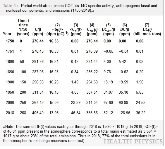
C(t) is total atm CO2, S(t) is Seuss 14C effect, CF(t) is FF atm CO2, CNF(t) is atm non-FF CO2, DE(t) is FF CO2 emissions

Summary

Despite an estimated 205 ppm of FF CO2 emitted since 1750, only 46.84 ppm (23%) of FF CO2 remains, while the other 77% is distributed into natural sinks/sources. As of 2018 atmospheric CO2 was 405, of which 12% (47 ppm) originated from FF.   And the other 88% (358 ppm) came from natural sources: 276 prior to 1750, and 82 ppm since.  Natural CO2 sources/sinks continue to drive rising atmospheric CO2, presently at a rate of 2 to 1 over FF CO2.

2.  Analysis of CO2 Flows Confirms Natural Dominance

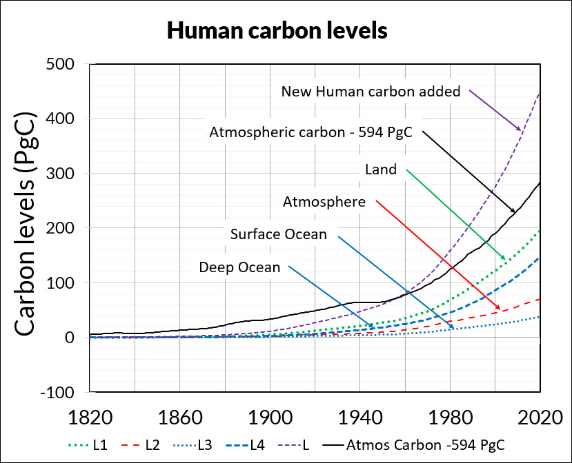
Figure 3. How human carbon levels change with time.

Independent research by Dr. Ed Berry focused on studying flows and level of CO2 sources and sinks.  The above summary chart from his published work presents a very similar result.

The graph above summarizes Dr. Berry’s findings. The lines represent CO2 added into the atmosphere since the 1750 level of 280 ppm. Based on IPCC data regarding CO2 natural sources and sinks, the black dots show the CO2 data. The small blue dots show the sum of all human CO2 emissions since they became measurable, irrespective of transfers of that CO2 from the atmosphere to land or to ocean.

Notice the CO2 data is greater than the sum of all human CO2 until 1960. That means nature caused the CO2 level to increase prior to 1960, with no reason to stop adding CO2 since. In fact, the analysis shows that in the year 2020, the human contribution to atmospheric CO2 level is 33 ppm, which means that from a 2020 total of 413 ppm, 280 is pre-industrial and 100 is added from land and ocean during the industrial era.

My synopsis of his work is IPCC Data: Rising CO2 is 75% Natural

A new carbon cycle model shows human emissions cause 25% and nature 75% of the CO2 increase is the title (and link) for Dr. Edwin Berry’s paper accepted in the journal Atmosphere August 12, 2021.

3. Nature Erases Pulses of Human CO2 Emissions  

Those committed to blaming humans for rising atmospheric CO2 sometimes admit that emitted CO2 (from any source) only stays in the air about 5 years (20% removed each year)  being absorbed into natural sinks.  But they then save their belief by theorizing that human emissions are “pulses” of additional CO2 which persist even when particular molecules are removed, resulting in higher CO2 concentrations.  The analogy would be a traffic jam on the freeway which persists long after the blockage is removed.

A recent study by Bud Bromley puts the fork in this theory.  His paper is A conservative calculation of specific impulse for CO2.  The title links to his text which goes through the math in detail.  Excerpts are in italics here with my bolds.

In the 2 years following the June 15, 1991 eruption of the Pinatubo volcano, the natural environment removed more CO2 than the entire increase in CO2 concentration due to all sources, human and natural, during the entire measured daily record of the Global Monitoring Laboratory of NOAA/Scripps Oceanographic Institute (MLO) May 17, 1974 to June 15, 1991. Then, in the 2 years after that, that CO2 was replaced plus an additional increment of CO2.

The data and graphs produced by MLO also show a reduction in slope of total CO2 concentration following the June 1991 eruption of Pinatubo, and also show the more rapid recovery of total CO2 concentration that began about 2 years after the 1991 eruption. This graph is the annual rate of change (i.e., velocity or slope) of total atmosphere CO2 concentration. This graph is not human CO2.

More recently is his study Scaling the size of the CO2 error in Friedlingstein et al.  Excerpts in italics with my bolds.

Since net human emissions would be a cumulative net of two fluxes, if there were a method to measure it, and since net global average CO2 concentration (i.e., NOAA Mauna Loa) is the net of two fluxes, then we should compare these data as integral areas. That is still an apples and oranges comparison because we only have the estimate of human emissions, not net human emissions. But at least the comparison would be in the right order of magnitude.

That comparison would look something like the above graphic. We would be comparing the entire area of the orange quadrangle to the entire blue area, understanding that the tiny blue area shown is much larger than actually is because the amount shown is human emissions only, not net human emissions. Human CO2 absorptions have not been subtracted. Nevertheless, it should be obvious that (1) B is not causing A, and (2) the orange area is enormously larger than the blue area.

Human emissions cannot be driving the growth rate (slope) observed in net global average CO2 concentration.

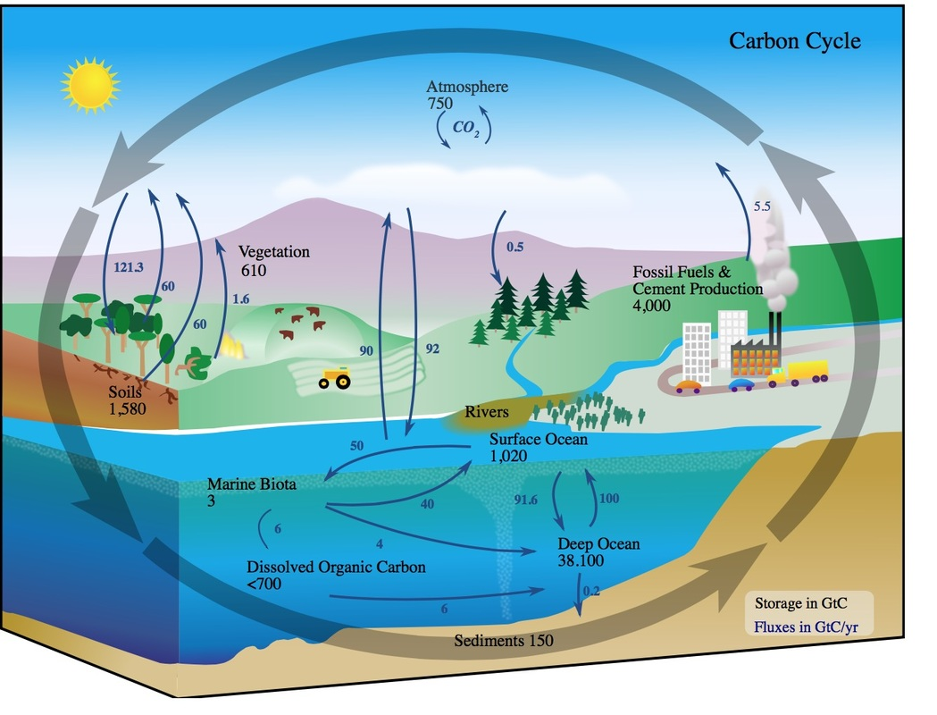
4.  Setting realistic proportions for the carbon cycle.

Hermann Harde applies a comparable perspective to consider the carbon cycle dynamics. His paper is Scrutinizing the carbon cycle and CO2 residence time in the atmosphere. Excerpts with my bolds.

Different to the IPCC we start with a rate equation for the emission and absorption processes, where the uptake is not assumed to be saturated but scales proportional with the actual CO2 concentration in the atmosphere (see also Essenhigh, 2009; Salby, 2016). This is justified by the observation of an exponential decay of 14C. A fractional saturation, as assumed by the IPCC, can directly be expressed by a larger residence time of CO2 in the atmosphere and makes a distinction between a turnover time and adjustment time needless.

Based on this approach and as solution of the rate equation we derive a concentration at steady state, which is only determined by the product of the total emission rate and the residence time. Under present conditions the natural emissions contribute 373 ppm and anthropogenic emissions 17 ppm to the total concentration of 390 ppm (2012). For the average residence time we only find 4 years.

The stronger increase of the concentration over the Industrial Era up to present times can be explained by introducing a temperature dependent natural emission rate as well as a temperature affected residence time. With this approach not only the exponential increase with the onset of the Industrial Era but also the concentrations at glacial and cooler interglacial times can well be reproduced in full agreement with all observations.

So, different to the IPCC’s interpretation the steep increase of the concentration since 1850 finds its natural explanation in the self accelerating processes on the one hand by stronger degassing of the oceans as well as a faster plant growth and decomposition, on the other hand by an increasing residence time at reduced solubility of CO2 in oceans. Together this results in a dominating temperature controlled natural gain, which contributes about 85% to the 110 ppm CO2 increase over the Industrial Era, whereas the actual anthropogenic emissions of 4.3% only donate 15%. These results indicate that almost all of the observed change of CO2 during the Industrial Era followed, not from anthropogenic emission, but from changes of natural emission. The results are consistent with the observed lag of CO2 changes behind temperature changes (Humlum et al., 2013; Salby, 2013), a signature of cause and effect. Our analysis of the carbon cycle, which exclusively uses data for the CO2 concentrations and fluxes as published in AR5, shows that also a completely different interpretation of these data is possible, this in complete conformity with all observations and natural causalities.

5.  More CO2 Is Not a Problem But a Blessing

William Happer provides a framework for thinking about climate, based on his expertise regarding atmospheric radiation (the “greenhouse” mechanism).  But he uses plain language accessible to all.  The Independent Institute published the transcript for those like myself who prefer reading for full comprehension.  Source: How to Think about Climate Change  

His presentation boils down to two main points:  More CO2 will result in very little additional global warming. But it will increase productivity of the biosphere.  My synopsis is: Climate Change and CO2 Not a Problem  Brief excerpts in italics with my bolds.

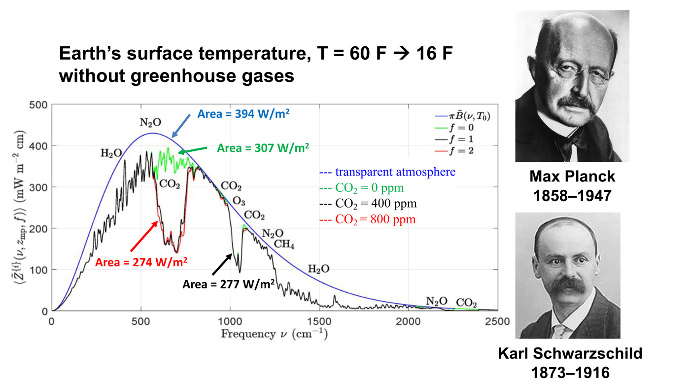
This is an important slide. There is a lot of history here and so there are two historical pictures. The top picture is Max Planck, the great German physicist who discovered quantum mechanics. Amazingly, quantum mechanics got its start from greenhouse gas-physics and thermal radiation, just what we are talking about today. Most climate fanatics do not understand the basic physics. But Planck understood it very well and he was the first to show why the spectrum of radiation from warm bodies has the shape shown on this picture, to the left of Planck. Below is a smooth blue curve. The horizontal scale, left to right is the “spatial frequency” (wave peaks per cm) of thermal radiation. The vertical scale is the thermal power that is going out to space. If there were no greenhouse gases, the radiation going to space would be the area under the blue Planck curve. This would be the thermal radiation that balances the heating of Earth by sunlight.

In fact, you never observe the Planck curve if you look down from a satellite. We have lots of satellite measurements now. What you see is something that looks a lot like the black curve, with lots of jags and wiggles in it. That curve was first calculated by Karl Schwarzschild, who first figured out how the real Earth, including the greenhouse gases in its atmosphere, radiates to space. That is described by the jagged black line. The important point here is the red line. This is what Earth would radiate to space if you were to double the CO2 concentration from today’s value. Right in the middle of these curves, you can see a gap in spectrum. The gap is caused by CO2 absorbing radiation that would otherwise cool the Earth. If you double the amount of CO2, you don’t double the size of that gap. You just go from the black curve to the red curve, and you can barely see the difference. The gap hardly changes.

The message I want you to understand, which practically no one really understands, is that doubling CO2 makes almost no difference.

The alleged harm from CO2 is from warming, and the warming observed is much, much less than predictions. In fact, warming as small as we are observing is almost certainly beneficial. It gives slightly longer growing seasons. You can ripen crops a little bit further north than you could before. So, there is completely good news in terms of the temperature directly. But there is even better news. By standards of geological history, plants have been living in a CO2 famine during our current geological period.

So, the takeaway message is that policies that slow CO2 emissions are based on flawed computer models which exaggerate warming by factors of two or three, probably more. That is message number one. So, why do we give up our freedoms, why do we give up our automobiles, why do we give up a beefsteak because of this model that does not work?

Takeaway message number two is that if you really look into it, more CO2 actually benefits the world. So, why are we demonizing this beneficial molecule that is making plants grow better, that is giving us slightly less harsh winters, a slightly longer growing season? Why is that a pollutant? It is not a pollutant at all, and we should have the courage to do nothing about CO2 emissions. Nothing needs to be done.

See Also Peter Stallinga 2023 Study  CO2 Fluxes Not What IPCC Telling You

Footnote:  The Core of the CO2 Issue Update July 15

An adversarial comment below goes to the heart of the issue:

“The increase of the CO2 level since 1850 are more than accounted for by manmade emissions.  Nature remains a net CO2 sink, not a net emitter.”

The data show otherwise.  Warming temperatures favor natural sources/sinks emitting more CO2 into the atmosphere, while previously captured CO2 shifts over time into long term storage as bicarbonates.  In fact, rising temperatures are predictive of rising CO2, as shown mathematically.

02/2025 Update–Temperature Changes, CO2 Follows

It is the ongoing natural contribution to atmospheric CO2 that is being denied.

Little Warming in June 2023 UAH Air Temps

The post below updates the UAH record of air temperatures over land and ocean. Each month and year exposes again the growing disconnect between the real world and the Zero Carbon zealots.  It is as though the anti-hydrocarbon band wagon hopes to drown out the data contradicting their justification for the Great Energy Transition.  Yes there is warming from an El Nino buildup but no basis to blame it on CO2.  

As an overview consider how recent rapid cooling  completely overcame the warming from the last 3 El Ninos (1998, 2010 and 2016).  The UAH record shows that the effects of the last one were gone as of April 2021, again in November 2021, and in February and June 2022  Now at year end 2022 and continuing into 2023 global temp anomaly is matching or lower than average since 1995, an ENSO neutral year. (UAH baseline is now 1991-2020).

For reference I added an overlay of CO2 annual concentrations as measured at Mauna Loa.  While temperatures fluctuated up and down ending flat, CO2 went up steadily by ~60 ppm, a 15% increase.

Furthermore, going back to previous warmings prior to the satellite record shows that the entire rise of 0.8C since 1947 is due to oceanic, not human activity.

gmt-warming-events

The animation is an update of a previous analysis from Dr. Murry Salby.  These graphs use Hadcrut4 and include the 2016 El Nino warming event.  The exhibit shows since 1947 GMT warmed by 0.8 C, from 13.9 to 14.7, as estimated by Hadcrut4.  This resulted from three natural warming events involving ocean cycles. The most recent rise 2013-16 lifted temperatures by 0.2C.  Previously the 1997-98 El Nino produced a plateau increase of 0.4C.  Before that, a rise from 1977-81 added 0.2C to start the warming since 1947.

Importantly, the theory of human-caused global warming asserts that increasing CO2 in the atmosphere changes the baseline and causes systemic warming in our climate.  On the contrary, all of the warming since 1947 was episodic, coming from three brief events associated with oceanic cycles. 

Update August 3, 2021

Chris Schoeneveld has produced a similar graph to the animation above, with a temperature series combining HadCRUT4 and UAH6. H/T WUWT

image-8


mc_wh_gas_web20210423124932

See Also Worst Threat: Greenhouse Gas or Quiet Sun?

June 2023 Update Little Warming Added After May El Nino Spike

banner-blog

With apologies to Paul Revere, this post is on the lookout for cooler weather with an eye on both the Land and the Sea.  While you will hear a lot about 2020-21 temperatures matching 2016 as the highest ever, that spin ignores how fast the cooling set in.  The UAH data analyzed below shows that warming from the last El Nino Had fully dissipated with chilly temperatures in all regions. After a warming blip in 2022, land and ocean temps dropped again with 2023 starting below the mean since 1995.  Now in March to May EL Nino appears in a Tropical ocean Spike.

UAH has updated their tlt (temperatures in lower troposphere) dataset for June 2023. Posts on their reading of ocean air temps this month preceded updated records from HadSST4.  I last posted on SSTs using HadSST4 El Nino Ocean Warming Abates May 2023. This month also has a separate graph of land air temps because the comparisons and contrasts are interesting as we contemplate possible cooling in coming months and years. Sometimes air temps over land diverge from ocean air changes.  For example in February, Tropical ocean temps alone moved upward, while temps in all land regions rebounded after hitting bottom.

In June, as shown later on, Global ocean air cooled led by dropping SH temps, despite continued warming in the Tropics and NH.  OTOH Global land air temps rose in both NH and SH with Tropical land little changed.  Thus the land + ocean Global UAH temperature record remained the same.

Note:  UAH has shifted their baseline from 1981-2010 to 1991-2020 beginning with January 2021.  In the charts below, the trends and fluctuations remain the same but the anomaly values change with the baseline reference shift.

Presently sea surface temperatures (SST) are the best available indicator of heat content gained or lost from earth’s climate system.  Enthalpy is the thermodynamic term for total heat content in a system, and humidity differences in air parcels affect enthalpy.  Measuring water temperature directly avoids distorted impressions from air measurements.  In addition, ocean covers 71% of the planet surface and thus dominates surface temperature estimates.  Eventually we will likely have reliable means of recording water temperatures at depth.

Recently, Dr. Ole Humlum reported from his research that air temperatures lag 2-3 months behind changes in SST.  Thus the cooling oceans now portend cooling land air temperatures to follow.  He also observed that changes in CO2 atmospheric concentrations lag behind SST by 11-12 months.  This latter point is addressed in a previous post Who to Blame for Rising CO2?

After a change in priorities, updates are now exclusive to HadSST4.  For comparison we can also look at lower troposphere temperatures (TLT) from UAHv6 which are now posted for June.  The temperature record is derived from microwave sounding units (MSU) on board satellites like the one pictured above. Recently there was a change in UAH processing of satellite drift corrections, including dropping one platform which can no longer be corrected. The graphs below are taken from the revised and current dataset.

The UAH dataset includes temperature results for air above the oceans, and thus should be most comparable to the SSTs. There is the additional feature that ocean air temps avoid Urban Heat Islands (UHI).  The graph below shows monthly anomalies for ocean air temps since January 2015.


Note 2020 was warmed mainly by a spike in February in all regions, and secondarily by an October spike in NH alone. In 2021, SH and the Tropics both pulled the Global anomaly down to a new low in April. Then SH and Tropics upward spikes, along with NH warming brought Global temps to a peak in October.  That warmth was gone as November 2021 ocean temps plummeted everywhere. After an upward bump 01/2022 temps reversed and plunged downward in June.  After an upward spike in July, ocean air everywhere cooled in August and also in September.   

After sharp cooling everywhere in January 2023, all regions were into negative territory. Note the Tropics matched the lowest, but since  have spiked sharply upward +0.9C, with the largest increase in May and June 2023.  NH also warmed, but SH ocean air was cooler by 0.23C, resulting in Global Ocean air cooling slightly. Mid-year 2023 looks similar to both 2021 and 2022, which also had summer peaks followed by cooling.  The strength of the El Nino will determine the latter half of this year.

Land Air Temperatures Tracking Downward in Seesaw Pattern

We sometimes overlook that in climate temperature records, while the oceans are measured directly with SSTs, land temps are measured only indirectly.  The land temperature records at surface stations sample air temps at 2 meters above ground.  UAH gives tlt anomalies for air over land separately from ocean air temps.  The graph updated for June is below.


Here we have fresh evidence of the greater volatility of the Land temperatures, along with extraordinary departures by SH land.  Land temps are dominated by NH with a 2021 spike in January,  then dropping before rising in the summer to peak in October 2021. As with the ocean air temps, all that was erased in November with a sharp cooling everywhere.  After a summer 2022 NH spike, land temps dropped everywhere, and in January, further cooling in SH and Tropics offset by an uptick in NH. 

Remarkably, in 2023, SH land air anomaly shot up 1.2C, from  -0.56C in January to +0.67 in April. Now in June, rising SH and NH Land air temps rose, pulling up the Global land anomaly by 0.13C.

The Bigger Picture UAH Global Since 1980


The chart shows monthly Global anomalies starting 01/1980 to present.  The average monthly anomaly is -0.06, for this period of more than four decades.  The graph shows the 1998 El Nino after which the mean resumed, and again after the smaller 2010 event. The 2016 El Nino matched 1998 peak and in addition NH after effects lasted longer, followed by the NH warming 2019-20.   An upward bump in 2021 was reversed with temps having returned close to the mean as of 2/2022.  March and April brought warmer Global temps, later reversed, and with the sharp drops in Nov., Dec. and January 2023 temps, there was no increase over 1980. Now in 2023 the May and June peak matches the two previous Julys.  Where it goes from here, up or down, remains to be seen.

TLTs include mixing above the oceans and probably some influence from nearby more volatile land temps.  Clearly NH and Global land temps have been dropping in a seesaw pattern, nearly 1C lower than the 2016 peak.  Since the ocean has 1000 times the heat capacity as the atmosphere, that cooling is a significant driving force.  TLT measures started the recent cooling later than SSTs from HadSST3, but are now showing the same pattern.  It seems obvious that despite the three El Ninos, their warming has not persisted, and without them it would probably have cooled since 1995.  Of course, the future has not yet been written.


June 2023 the Hottest Ever? Not So Fast!

For sure you’ve seen the headlines declaring June 2023 the Hottest month ever.  If you’re like me, your response is: That’s not the way June went down where I live.  Fortunately there is a website that allows anyone to check their personal experience with the weather station data nearby.  weatherspark.com provides data summaries for you to judge what’s going on in weather history where you live.  In my case a modern weather station is a few miles away  June 2023 Weather History at Montréal–Mirabel International Airport.  The story about June 2023 is evident below in charts and graphs from this site.  There’s a map that allows you to find your locale.

First, consider above the norms for June from the period 1980 to 2016.

Then, there’s June 2023 compared to the normal observations.

The graph shows May was warm, but not so much during June, pretty normal in fact.  But since climate is more than temperature, consider cloudiness.

Woah!  Most of the month was cloudy, which in summer means blocking the hot sun from hitting the surface.   And with all those clouds, let’s look at precipitation:

So, 19 days when it rained, including heavy rain, and sometimes thunderstorms, especially toward month end.  Given what we know about the hydrology cycles, that means a lot of heat removed upward from the surface.

So the implications for June temperatures in my locale.

There you have it before your eyes.  One Hot day, then cold, cool, warm
and ending comfortable.  Hottest June Ever!
Maybe in some imaginary world,  but not in the real one.

Summary:

Claims of hottest this or that month or year are based on averages of averages of temperatures, which in principle is an intrinsic quality and distinctive to a locale.  The claim involves selecting some places and time periods where warming appears, while ignoring other places where it has been cooling.

Remember:  They want you to panic.  Before doing so, check out what the data says in your neck of the woods.


Climate Primer for Misguided Kids Suing Montana (with Quiz added)

Before reading the discussion on climate science, here is a quiz followed by the correct answers provided by Andrew L. Urban in his Spectator Australia article Climate Science for Dummies – the TV show. Excerpts in italics with my bolds and added images.

Given the ever-escalating hysteria about this catastrophic, urgent, the-end-is-nigh ‘climate emergency’ that has been turbo-charged by world leaders who have the staff and resources to ‘do a bit of research’, here are ten questions I’d like to put to a panel on my Climate Science for Dummies TV show.

The panel would comprise our Prime Minister Anthony Albenese (along with any responsible ministers), Britain’s Prime Minister (?) Boris Johnson, US President Joe Biden and his climate tsar John Kerry, and all those in the world’s mainstream media who have swallowed the Katastrophe Koolade.  (Answers at the end.)

Ten Questions

Question 1: Who said all of the following?

    • For the next twenty to thirty years, man-made warming effects on climate extremes will be swamped by natural climate variability.
    • The mild man-made warming may even be beneficial by reducing the number of extreme events.
    • Neither IPCC models nor emissions forecasting are good enough to forecast extreme weather events up to the end of the century.

Question 2: Who said that ‘warming would melt the Himalayan glaciers by 2035 and deprive billions on the sub-continent of fresh water’?

Question 3: How much of the Earth’s atmosphere is made up of carbon dioxide?

Question 4: How much of that amount is man-made (fossil fuel emissions)?

Question 5: Who said ‘enjoy snow now – by 2020 it will be gone’?

Question 6: Who said it is not true that 97 per cent of scientists unreservedly accept that AGW theory is fixed, or that CO2 is a ‘pollutant’ and its production should be penalised?

Question 7: Who said that the push to curtail carbon dioxide threatens to exacerbate poverty without improving the environment?

Question 8: Who said that ‘there is no climate emergency’ and that ‘climate science has degenerated into a discussion based on beliefs, not on sound self-critical science’?

Question 9: Our annual emissions are 400-500 million tonnes. How many tonnes of carbon dioxide do our grasslands and forests ‘breath in’?

Question 10: Who made the following declaration? ‘Frankly, it looks like we’re on a crash course towards massive species extinctions in the next 20 years. We could lose one-fifth or 20 per cent of our species within the next two decades.’

Answers.

Q1: The IPCC’s November 2011 special draft report on extreme weather events.

Q2: The IPCC Fourth Report.

Q3: 0.04 per cent.

Q4: 3 per cent.

Q5: Catherine Pickering of Griffith University, reported in The Australian on July 3, 2012.

Q6: A group of 33 current and former Fellows of the Geological Society in an open letter to their president in 2018. (The Geological Society is the United Kingdom’s national academy of sciences, a Fellowship of some 1,600 of the world’s most eminent scientists.)

Q7: The 300 scientists who signed a petition to then President Trump, on February 23, 2017. In the accompanying letter, MIT professor emeritus Richard Lindzen called on the United States and other nations to ‘change course on an outdated international agreement that targets minor greenhouse gases’ starting with carbon dioxide.

Q8: The Climate Declaration issued in June 2022 by Climate Intelligence, signed by over 1,100 scientists from around the world.

Q9: Some 940 million tonnes.

Q10: The VP for Field Programs at Defenders of Wildlife, Nina Fascione, in 2003.

Background Climate Science from previous post.

Jack Hellner explains the basics in his American Thinker article This is some of the garbage we can expect with indoctrinated kids and greedy lawyers.  Excerpts in italics with my bolds and added images.

These children say that their lives have been destroyed because of coal and oil so they are suing Montana.

A group of Montana youth who say their lives are already being affected by climate change and that state government is failing to protect them are the first of dozens of such efforts to get their lawsuit to trial Monday. They will try to persuade a judge that the state’s allegiance to fossil fuel development endangers their health and livelihoods and those of future generations.

Lawsuits and policies should be based on the truth and scientific facts, not on easily manipulated computer models and made up predictions which have consistently been wrong, like this lawsuit and the radical green policies which are being forced on the American people. 

Maybe the state should take the kids to underdeveloped countries that haven’t developed and used their natural resources to see how lucky they are. Then the state should send them a bill for greatly improving their quality and length of life. 

The line of defense against this nuisance lawsuit is long because it is based on factual scientific data.  They can have it presented in the simplest form since they have been taught not to ask questions or do research. 

They should be told that the Earth was just as warm 1,000 years ago as it is today. 

Then they should have the scientific fact pointed out to them that a Little Ice Age occurred from around 1300 to 1860 where the Earth cooled a little. 

Dr. Syun Akasofu 2009 diagram from his paper Two Natural Components of Recent Warming.

Then they should be shown that the Earth has only warmed a little in the last 160 years since the Little Ice Age ended, and they should be able to comprehend that the Earth always warms a little after an ice age ends. 

They should be told that although there has been one or two degrees of warming the last 160 years, we also had a 35-year period of cooling from 1940-1975 where the public was warned that a catastrophic ice age was coming. 

It should be possible for the youth to understand, even as journalists, politicians, and bureaucrats can’t seem to, that if temperatures sometimes rise and sometimes fall while crude oil use and coal use are constantly rising rapidly, that there is no correlation between our use of natural resources and temperatures, nor climate change. 

Figure 5.1. Comparative dynamics of the World Fuel Consumption (WFC) and Global Surface Air Temperature Anomaly (ΔT), 1861-2000. The thin dashed line represents annual ΔT, the bold line—its 13-year smoothing, and the line constructed from rectangles—WFC (in millions of tons of nominal fuel) (Klyashtorin and Lyubushin, 2003). Source: Frolov et al. 2009

They should be able to understand the simple scientific concept that if there is no correlation, there can be no causation. 

They should also be taught that CO2 is a clear, innocuous, non-pollutant gas that makes plants thrive and allows the World to be fed. There is also no correlation between the rise to a small 420-parts-per-million in the atmosphere and temperatures or sea levels. 

Oceans, which average over 12,000 feet deep, have risen a miniscule 9 inches in 140 years, which is essentially immeasurable, let alone be attributed to CO2, oil, humans or anything else. There are thousands of natural variables.

It would help if children were shown the truth as to how life expectancy has almost doubled since we started using coal and oil and people in countries that don’t use oil and coal live shorter lives. 

Maybe it would help to inform them of all the products that are derived from crude oil and ask them if their lives would be better off without them. 

A Partial list of the over 6,000 products made from one barrel of oil (after creating 19 gallons of gasoline) 

Maybe the children should be shown how all of the previous dire predictions have been wrong including one from over 100 years ago that predicted the ice would soon be gone, that oceans were dying, and coastal cities would soon disappear. 

“The Arctic Ocean is warming up, icebergs are growing scarcer, and in some places the seals are finding the water too hot. Reports from fishermen, seal hunters, and explorers all point to a radical change in climate conditions and hitherto unheard‐of temperatures in the Arctic zone. Exploration expeditions report that scarcely any ice has been met as far north as 81 degrees 29 minutes. Within a few years it is predicted that due to the ice melt the sea will rise and make most coastal cities uninhabitable.” — from an Associated Press report published in The Washington Post on November 2, 1922

It is a true shame that most of the media along with educators spend their time scaring children that we are destroying the Earth and that we don’t have much time left instead of doing their job to educate and inform them and to teach them to ask questions and do research. It is no wonder so many young people are suicidal and don’t want children. 

We get extremely destructive government policies when people
are indoctrinated instead of told the truth.

We should count our blessings that the Earth has such an abundance of natural resources and that humans were given a brain that allowed them to develop them.

El Nino Ocean Warming Abates May 2023

The best context for understanding decadal temperature changes comes from the world’s sea surface temperatures (SST), for several reasons:

  • The ocean covers 71% of the globe and drives average temperatures;
  • SSTs have a constant water content, (unlike air temperatures), so give a better reading of heat content variations;
  • A major El Nino was the dominant climate feature in recent years.

HadSST is generally regarded as the best of the global SST data sets, and so the temperature story here comes from that source. Previously I used HadSST3 for these reports, but Hadley Centre has made HadSST4 the priority, and v.3 will no longer be updated.  HadSST4 is the same as v.3, except that the older data from ship water intake was re-estimated to be generally lower temperatures than shown in v.3.  The effect is that v.4 has lower average anomalies for the baseline period 1961-1990, thereby showing higher current anomalies than v.3. This analysis concerns more recent time periods and depends on very similar differentials as those from v.3 despite higher absolute anomaly values in v.4.  More on what distinguishes HadSST3 and 4 from other SST products at the end. The user guide for HadSST4 is here.

The Current Context

The chart below shows SST monthly anomalies as reported in HadSST4 starting in 2015 through May 2023.  A global cooling pattern is seen clearly in the Tropics since its peak in 2016, joined by NH and SH cycling downward since 2016. 

Note that in 2015-2016 the Tropics and SH peaked in between two summer NH spikes.  That pattern repeated in 2019-2020 with a lesser Tropics peak and SH bump, but with higher NH spikes. By end of 2020, cooler SSTs in all regions took the Global anomaly well below the mean for this period.  In 2021 the summer NH summer spike was joined by warming in the Tropics but offset by a drop in SH SSTs, which raised the Global anomaly slightly over the mean.

Then in 2022, another strong NH summer spike peaked in August, but this time both the Tropic and SH were countervailing, resulting in only slight Global warming, later receding to the mean.   Oct./Nov. temps dropped  in NH and the Tropics took the Global anomaly below the average for this period. After an uptick in December, temps in January 2023 dropped everywhere, strongest in NH, with the Global anomaly further below the mean since 2015.

Now comes El Nino as shown by the upward spike in the Tropics since January, the anomaly nearly doubling from 0.45C to 0.83C.  SH stayed the same as March, but NH also increased 0.13, resulting in a Global anomaly of 0.85C.  However, in May 2023, both the Tropics and SH temps dropped down, reducing the Global anomaly to 0.82C dispite an upward bump in NH.

A longer view of SSTs

To enlarge, open in new tab.

The graph above is noisy, but the density is needed to see the seasonal patterns in the oceanic fluctuations.  Previous posts focused on the rise and fall of the last El Nino starting in 2015.  This post adds a longer view, encompassing the significant 1998 El Nino and since.  The color schemes are retained for Global, Tropics, NH and SH anomalies.  Despite the longer time frame, I have kept the monthly data (rather than yearly averages) because of interesting shifts between January and July.1995 is a reasonable (ENSO neutral) starting point prior to the first El Nino. 

The sharp Tropical rise peaking in 1998 is dominant in the record, starting Jan. ’97 to pull up SSTs uniformly before returning to the same level Jan. ’99. There were strong cool periods before and after the 1998 El Nino event. Then SSTs in all regions returned to the mean in 2001-2. 

SSTS fluctuate around the mean until 2007, when another, smaller ENSO event occurs. There is cooling 2007-8,  a lower peak warming in 2009-10, following by cooling in 2011-12.  Again SSTs are average 2013-14.

Now a different pattern appears.  The Tropics cooled sharply to Jan 11, then rise steadily for 4 years to Jan 15, at which point the most recent major El Nino takes off.  But this time in contrast to ’97-’99, the Northern Hemisphere produces peaks every summer pulling up the Global average.  In fact, these NH peaks appear every July starting in 2003, growing stronger to produce 3 massive highs in 2014, 15 and 16.  NH July 2017 was only slightly lower, and a fifth NH peak still lower in Sept. 2018.

The highest summer NH peaks came in 2019 and 2020, only this time the Tropics and SH were offsetting rather adding to the warming. (Note: these are high anomalies on top of the highest absolute temps in the NH.)  Since 2014 SH has played a moderating role, offsetting the NH warming pulses. After September 2020 temps dropped off down until February 2021.  In 2021-22 there were again summer NH spikes, but in 2022 moderated first by cooling Tropics and SH SSTs, then in October to January 2023 by deeper cooling in NH and Tropics.  

Now in 2023 the Tropics flip from below to above average, and NH starts building up for a summer peak comparable to previous years. In May warming in the Tropics and SH abated, while NH showed a typical upward bump.

What to make of all this? The patterns suggest that in addition to El Ninos in the Pacific driving the Tropic SSTs, something else is going on in the NH.  The obvious culprit is the North Atlantic, since I have seen this sort of pulsing before.  After reading some papers by David Dilley, I confirmed his observation of Atlantic pulses into the Arctic every 8 to 10 years.

Contemporary AMO Observations

Through January 2023 I depended on the Kaplan AMO Index (not smoothed, not detrended) for N. Atlantic observations. But it is no longer being updated, and NOAA says they don’t know its future.  So I find only the Hadsst AMO dataset has data through April.  It differs from Kaplan, which reported average absolute temps measured in N. Atlantic.  “Hadsst AMO  follows Trenberth and Shea (2006) proposal to use the NA region EQ-60°N, 0°-80°W and subtract the global rise of SST 60°S-60°N to obtain a measure of the internal variability, arguing that the effect of external forcing on the North Atlantic should be similar to the effect on the other oceans.”  So the values represent differences between the N. Atlantic and the Global ocean.

The chart above confirms what Kaplan also showed.  As August is the hottest month for the N. Atlantic, its varibility, high and low, drives the annual results for this basin.  Note also the peaks in 2010, lows after 2014, and a rise in 2021. An annual chart below is informative:

Note the difference between blue/green years, beige/brown, and purple/red years.  2010, 2021, 2022 all peaked strongly in August or September.  1998 and 2007 were mildly warm.  2016 and 2018 were matching or cooler than the global average.  2023 is starting out slightly warm.

Summary

The oceans are driving the warming this century.  SSTs took a step up with the 1998 El Nino and have stayed there with help from the North Atlantic, and more recently the Pacific northern “Blob.”  The ocean surfaces are releasing a lot of energy, warming the air, but eventually will have a cooling effect.  The decline after 1937 was rapid by comparison, so one wonders: How long can the oceans keep this up? 

Footnote: Why Rely on HadSST4

HadSST is distinguished from other SST products because HadCRU (Hadley Climatic Research Unit) does not engage in SST interpolation, i.e. infilling estimated anomalies into grid cells lacking sufficient sampling in a given month. From reading the documentation and from queries to Met Office, this is their procedure.

HadSST4 imports data from gridcells containing ocean, excluding land cells. From past records, they have calculated daily and monthly average readings for each grid cell for the period 1961 to 1990. Those temperatures form the baseline from which anomalies are calculated.

In a given month, each gridcell with sufficient sampling is averaged for the month and then the baseline value for that cell and that month is subtracted, resulting in the monthly anomaly for that cell. All cells with monthly anomalies are averaged to produce global, hemispheric and tropical anomalies for the month, based on the cells in those locations. For example, Tropics averages include ocean grid cells lying between latitudes 20N and 20S.

Gridcells lacking sufficient sampling that month are left out of the averaging, and the uncertainty from such missing data is estimated. IMO that is more reasonable than inventing data to infill. And it seems that the Global Drifter Array displayed in the top image is providing more uniform coverage of the oceans than in the past.

uss-pearl-harbor-deploys-global-drifter-buoys-in-pacific-ocean

USS Pearl Harbor deploys Global Drifter Buoys in Pacific Ocean


Climate Primer for Misguided Kids Suing Montana

Jack Hellner explains the basics in his American Thinker article This is some of the garbage we can expect with indoctrinated kids and greedy lawyers.  Excerpts in italics with my bolds and added images.

These children say that their lives have been destroyed because of coal and oil so they are suing Montana.

A group of Montana youth who say their lives are already being affected by climate change and that state government is failing to protect them are the first of dozens of such efforts to get their lawsuit to trial Monday. They will try to persuade a judge that the state’s allegiance to fossil fuel development endangers their health and livelihoods and those of future generations.

Lawsuits and policies should be based on the truth and scientific facts, not on easily manipulated computer models and made up predictions which have consistently been wrong, like this lawsuit and the radical green policies which are being forced on the American people. 

Maybe the state should take the kids to underdeveloped countries that haven’t developed and used their natural resources to see how lucky they are. Then the state should send them a bill for greatly improving their quality and length of life. 

The line of defense against this nuisance lawsuit is long because it is based on factual scientific data.  They can have it presented in the simplest form since they have been taught not to ask questions or do research. 

They should be told that the Earth was just as warm 1,000 years ago as it is today. 

Then they should have the scientific fact pointed out to them that a Little Ice Age occurred from around 1300 to 1860 where the Earth cooled a little. 

Dr. Syun Akasofu 2009 diagram from his paper Two Natural Components of Recent Warming.

Then they should be shown that the Earth has only warmed a little in the last 160 years since the Little Ice Age ended, and they should be able to comprehend that the Earth always warms a little after an ice age ends. 

They should be told that although there has been one or two degrees of warming the last 160 years, we also had a 35-year period of cooling from 1940-1975 where the public was warned that a catastrophic ice age was coming. 

It should be possible for the youth to understand, even as journalists, politicians, and bureaucrats can’t seem to, that if temperatures sometimes rise and sometimes fall while crude oil use and coal use are constantly rising rapidly, that there is no correlation between our use of natural resources and temperatures, nor climate change. 

Figure 5.1. Comparative dynamics of the World Fuel Consumption (WFC) and Global Surface Air Temperature Anomaly (ΔT), 1861-2000. The thin dashed line represents annual ΔT, the bold line—its 13-year smoothing, and the line constructed from rectangles—WFC (in millions of tons of nominal fuel) (Klyashtorin and Lyubushin, 2003). Source: Frolov et al. 2009

They should be able to understand the simple scientific concept that if there is no correlation, there can be no causation. 

They should also be taught that CO2 is a clear, innocuous, non-pollutant gas that makes plants thrive and allows the World to be fed. There is also no correlation between the rise to a small 420-parts-per-million in the atmosphere and temperatures or sea levels. 

Oceans, which average over 12,000 feet deep, have risen a miniscule 9 inches in 140 years, which is essentially immeasurable, let alone be attributed to CO2, oil, humans or anything else. There are thousands of natural variables.

It would help if children were shown the truth as to how life expectancy has almost doubled since we started using coal and oil and people in countries that don’t use oil and coal live shorter lives. 

Maybe it would help to inform them of all the products that are derived from crude oil and ask them if their lives would be better off without them. 

A Partial list of the over 6,000 products made from one barrel of oil (after creating 19 gallons of gasoline) 

Maybe the children should be shown how all of the previous dire predictions have been wrong including one from over 100 years ago that predicted the ice would soon be gone, that oceans were dying, and coastal cities would soon disappear. 

“The Arctic Ocean is warming up, icebergs are growing scarcer, and in some places the seals are finding the water too hot. Reports from fishermen, seal hunters, and explorers all point to a radical change in climate conditions and hitherto unheard‐of temperatures in the Arctic zone. Exploration expeditions report that scarcely any ice has been met as far north as 81 degrees 29 minutes. Within a few years it is predicted that due to the ice melt the sea will rise and make most coastal cities uninhabitable.” — from an Associated Press report published in The Washington Post on November 2, 1922

It is a true shame that most of the media along with educators spend their time scaring children that we are destroying the Earth and that we don’t have much time left instead of doing their job to educate and inform them and to teach them to ask questions and do research. It is no wonder so many young people are suicidal and don’t want children. 

We get extremely destructive government policies when people
are indoctrinated instead of told the truth.

We should count our blessings that the Earth has such an abundance of natural resources and that humans were given a brain that allowed them to develop them.